![]()
Prev Page--Contents || Next Page--Geography
Introduction
Purpose and Scope of the Investigation
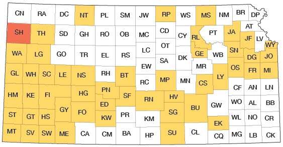
A program of investigation of the ground-water resources of Kansas was begun in 1937 by the U. S. Geological Survey and State Geological Survey of Kansas with the co-operation of the Division of Sanitation of the State Board of Health and the Division of Water Resources of the State Board of Agriculture. The investigation upon which this report is based was begun in June 1949. It is similar to other investigations that have been completed or are being made in other counties in Kansas. The present status of investigations resulting from this program is shown in Figure 1.
Fig. 1--Index map of Kansas showing area described in this report and areas covered by other online geologic reports, as of Aug. 2008. For additional information, please visit the KGS Geologic Maps of Kansas Page.
Ground water is one of the principal natural resources of Sherman County as well as of much of western Kansas. Nearly all public, domestic, railroad, and stock water supplies are obtained from wells. Ground water is being used to some extent for irrigation, and that this use will increase in the future is probable. At the present rate of withdrawal, the danger of seriously depleting the water supply is slight; but there is a definite need for an adequate understanding of the quality and quantity of the available supply and where additional supplies can be obtained.
The investigation was made under the general administration of A. N. Sayre, Chief of the Ground-Water Branch of the U. S. Geological Survey and under the immediate supervision of V. C. Fishel, District Engineer in charge of ground-water investigations in Kansas.
Location and Extent of the Area
Sherman County is in the High Plains in northwestern Kansas. It is bounded on the north by Cheyenne and Rawlins counties, on the east by Thomas County, on the South by Logan and Wallace counties, and on the west by Kit Carson County, Colorado (Fig. 1) It contains all or part of 30 townships from T. 6 S. to T. 10 S. and from R. 37 W. to R. 42 W. and has an area of 1,055 square miles.
Previous Investigations
No detailed geologic reports on Sherman County have been published, but several reports that refer to the county either directly or in a general way have been published. As early as 1895, a comprehensive report on geology and ground water along the Kansas-Colorado state line was published by the U. S. Geological Survey (Hay, 1895). This report discussed the source and the quantity of ground water, geology, and water-bearing formations in the area. Several references to Sherman County were made. A report on the progress of the Division of Hydrography for 1893 and 1894 (Newell, 1896) contained records of 50 wells in Sherman County which were measured by Hay. In 1897 Haworth contributed reports on the physiography of western Kansas (Haworth, 1897), on the physical properties of Tertiary rocks in Kansas (Haworth, 1897a), and on the geology of underground water in western Kansas (Haworth, 1897b).
A report of the Board of Irrigation Survey and Experiment to the State Legislature of Kansas for the years 1895 and 1896 was concerned with history, irrigation law, and station reports; a state-financed experimental pumping station near Goodland was described in detail (Sutton, 1897, pp. 21-24). Johnson (1901, 1902) reported on the utilization of the High Plains with special attention being given to source, availability, and use of ground water in western Kansas. In 1905 a preliminary report on the geology and ground-water resources of the central Great Plains made brief reference to the geology and hydrology of Sherman County (Darton, 1905, p. 317). In 1911 in a report on the quality of water supplies in Kansas, Parker listed analyses of ground waters from Sherman County and made several references to the geology of the county. A report on a reconnaissance soil survey in western Kansas (Coffey and Rice, 1912) included Sherman County. A special report on well waters in Kansas by Haworth (1913, p. 98) contains a log of a deep well drilled at Goodland.
Adams and Martin (1929) described an important Pliocene fossil discovery in Sherman County. In 1931 the State Geological Survey of Kansas published a very detailed report on the geology of Wallace County (Elias, 1931), which borders Sherman County on the south. This report discussed the geologic formations in Wallace County and gave a brief summary of the water resources of each township. A report by Landes (1937) on the mineral resources of Kansas counties briefly mentioned the water supplies and undeveloped mineral resources in Sherman County. In the same year Elias (1937) reported on the geology of Rawlins and Decatur counties with special reference to ground water. Rawlins County borders the northeastern edge of Sherman County. In 1940 Moore and others prepared a generalized report on the ground-water resources of Kansas and in 1945 Frye prepared a report on the geology and groundwater resources of Thomas County which borders Sherman on the east. In addition, reports by Ver Wiebe contain paragraphs summing up the results of test drilling for oil and gas in Sherman County (Ver Wiebe, 1940, p. 104; 1943, p. 86; 1946, p. 107).
Methods of Investigation
This report is based on about 5 months of field work done in the summer and fall of 1949. Data on 326 wells were obtained; most of these were measured with a steel tape to determine the depth of the well and the depth to water level. Well owners and drillers were interviewed regarding yield and drawdown of wells and the character of water-bearing materials. Pumping tests on irrigation wells were made by Woodrow W. Wilson and me to determine the yield of wells and the permeability of water-bearing materials. Samples of water from 24 representative wells in the county were collected; chemical analyses of the water were made in the Water and Sewage Laboratory of the Kansas State Board of Health at Lawrence by Howard A. Stoltenberg, chemist.
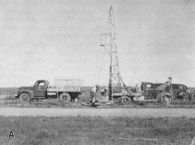
During the course of the investigation the surficial geology was studied and a geologic map (Pl. 1) was prepared. The character of the material beneath the surface was determined by the drilling of 29 test holes. These test holes were drilled with the portable hydraulic-rotary drilling machine owned by the State Geological Survey of Kansas and operated by William T. Connor and Max Yazza (Pl. 3A). Samples of the drill cuttings were collected and studied in the field and later examined in the office with a binocular microscope. The altitude of the surface at the test holes and of the measuring points of the wells were determined by level parties headed by William A. Carlson and Rex Huff, using a plane table and alidade.
Plate 3A--Hydraulic-rotary drilling rig owned by the State Geological Survey of Kansas.
The wells shown on Plates 1 and 2 were located within the sections by use of an odometer. The base map of the county used in these plates was prepared by Joseph C. Weakly from a county map compiled by the State Highway Commission of Kansas. Geologic mapping was done on a map obtained from the United States Department of Agriculture, Soil Conservation Service; drainage was adapted from maps issued by the Soil Conservation Service.
Well-numbering System
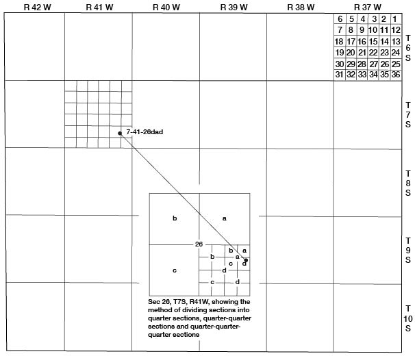
The well and test-hole numbers used in this report give the location of wells according to General Land Office surveys and according to the following formula: township, range, section, 160-acre tract within that section, 40-acre tract within that quarter section, and 10-acre tract within the quarter-quarter section, if this subdivision can be determined precisely. The 160-acre, 40-acre, and 10-acre tracts are designated a, b, c, or d in a counterclockwise direction beginning in the northeast quarter. If two or more wells are located within a 10-acre tract, the wells are numbered consecutively as inventoried. An example of this well-numbering system is given in Figure 2.
Fig. 2--Map of Sherman County illustrating the well-numbering system used in this report.
Acknowledgments
I am indebted to many residents of Sherman County who gave permission to measure their wells and supplied other helpful and pertinent information. Special thanks are extended to owners of irrigation wells who permitted pumping tests on their wells to be made. A. J. Foust of Goodland furnished logs of several irrigation wells and test holes and Dan Kramer, driller from Goodland, and Charles Harmon, driller from Kanorado, furnished information on wells in the county.
The manuscript for this report has been critically reviewed by several members of the Federal and State Geological Surveys: by Robert V. Smrha, Chief Engineer, and George S. Knapp, Engineer, of the Division of Water Resources of the Kansas State Board of Agriculture; and by Dwight F. Metzler, Director, and W. O. Hilton, Geologist, of the Division of Sanitation of the Kansas State Board of Health. The illustrations were drafted by Woodrow W. Wilson and Joseph C. Weakly of the Federal Geological Survey. The manuscript was typed by Wanda H. Hansen.
Prev Page--Contents || Next Page--Geography
Kansas Geological Survey, Geology
Placed on web Aug. 1, 2008; originally published Nov. 1953.
Comments to webadmin@kgs.ku.edu
The URL for this page is http://www.kgs.ku.edu/General/Geology/Sherman/02_intro.html