![]()
Prev Page--Introduction || Next Page--Permian
Stratigraphy, continued
Pennsylvanian System
Des Moines Series
The Pennsylvanian rocks of the Des Moines Series are represented in the report area by the Cherokee and Marmaton Groups.
Cherokee Group
Rocks of the Cherokee Group of Middle Pennsylvanian age are about 480-625 feet thick. They consist mainly of medium- to dark-gray shale and siltstone but also include lesser amounts of greenish-gray and red shale. Black shale is commonly associated with thin coal beds. White to light-gray fine- to medium-grained, in part limy or dolomitic, sandstone occurs throughout; some sandstone beds are as much as 30 feet thick (pl. 4). Thin beds mainly of buff or medium-dark-gray, in part argillaceous, limestone and dolomite occur throughout the group but are most abundant in the upper half. The basal unit of the Cherokee--called the Pennsylvanian basal conglomerate by drillers--consists of conglomeratic sandy siltstone, sandstone, or sandy shale 4-5 feet thick and contains pyrite, glauconite, fragments of very light gray to very pale orange chert and reddishbrown ironstone, and quartz grains. The chert is dense, quartzose, tripolitic, or spicular.
Marmaton Group
Rocks of the Marmaton Group, the upper unit of the Des Moines Series, are 115-155 feet thick, Drillers' logs of several wells indicate, however, that the group may locally range from 85 to 165 feet in thickness. The contact between the Marmaton and Cherokee Groups is difficult to identify, especially in drillers' logs, because limestone beds in the lower part of the Marmaton Group and upper part of the Cherokee Group apparently lack lateral continuity. Rocks of the Marmaton Group are mainly medium-gray, pale-yellowish-brown, or buff argillaceous limestone, but they also include abundant medium-gray, greenish-gray, or dark-gray to black partly calcareous shale. The limestone is dolomitic in the eastern part of the area. Light-gray to pale-yellow-brown very fine grained argillaceous sandstone and coal occur in small amounts.
Missouri Series
The Missouri Series in the report area comprises the Pleasanton, Kansas City, and Lansing Groups, Rocks in the upper part of the Kansas City Group and in the Lansing Group were divided into formations in eastern Shawnee County (chap. A, this report). However, the formations of only the Lansing Group could be recognized with certainty in western Shawnee County and vicinity.
Pleasanton Group
The lowest unit of the Missouri Series (Upper Pennsylvanian), the Pleasanton Group, is about 70-115 feet thick. It is mainly medium- to dark-gray shale and siltstone. The upper half contains beds of medium-light-gray and grayish-brown very fine grained silty calcareous micaceous sandstone and a few beds of brown and gray dense to finely crystalline limestone (pl. 4).
Kansas City Group
Rocks of the Kansas City Group, about 230-265 feet thick, are primarily limestone but include a fairly thick widespread shale bed at the top. The limestone is very pale orange, pale yellowish brown, buff, or medium gray, dense to very fine grained and very finely crystalline, and in part argillaceous. Locally the uppermost and lowermost limestone units are dolomitic. Several thin zones of oolitic and oolicastic limestone are commonly present in the upper and the "lower-middle" parts, Light- to medium-gray or pale-yellowish-brown dense partly spicular chert characterizes several limestone units. Much of the limestone is fossiliferous, and some is glauconitic.
Thin units of medium-gray to medium-dark-gray partly calcareous shale and of dark-gray to black partly coaly shale are interbedded with the limestone; the black shales are widespread. The shale unit at the top contains various amounts of light-gray to medium-light-gray very fine to fine-grained calcareous micaceous sandstone; in the northwestern part of the area, it is made up entirely of sandstone.
Lansing Group
Rocks of the Lansing Group, about 80-100 feet thick, are composed, in ascending order, of the Plattsburg Limestone, Vilas Shale, and Stanton Limestone. The Plattsburg Limestone, about 15-30 feet thick, is medium light gray to very pale orange or pale yellowish brown, dense to very fine grained and very finely crystalline, and generally fossiliferous. Medium-light-gray to medium-dark-gray dense spicular chert is sparse to moderately abundant. The Vilas Shale, about 10-30 feet thick, is medium to dark gray and partly calcareous, and it contains one or more thin beds of fossiliferous limestone. The Stanton Limestone, about 35-55 feet thick, is primarily light-gray or buff dense to very fine grained fossiliferous limestone, although locally it contains black, partly coaly shale near its base and a thin bed of gray partly calcareous and partly dolomitic sandstone near its top.
Virgil Series
Rocks between the Lansing and Shawnee Groups, formerly divided into the Pedee Group (Missouri Series) and the overlying Douglas Group (Virgil Series), were reclassified by the State Geological Survey of Kansas (O'Connor, 1963) as a result of detailed work by Stanton M. Ball. Except for the series and stage names, this new classification was adopted by the U.S. Geological Survey in the report on eastern Shawnee County and vicinity (Johnson and Adkison, chap. A, this report). As redefined, the Douglas Group includes all strata from the top of the Lansing Group to the base of the Shawnee Group and comprises the Stranger Formation and the overlying Lawrence Formation. The Douglas ranges in thickness from about 225 to 265 feet and consists mainly of noncarbonate clastic rock (pl. 4).
Stranger Formation--The Stranger Formation, about 95-135 feet thick, consists dominantly of light-gray to medium-light-gray very fine to fine-grained micaceous sandstone and medium- to dark-gray, olive-gray, and grayish-red partly sandy shale. Some sandstone beds include fine fragments of carbonaceous material. A thin coal bed occurs near the base of the Stranger in the Murchison Federal Land Bank 1 well.
Lawrerence Formation--Rocks of the Lawrence Formation are about 125-140 feet thick and are chiefly medium-gray shale. At the base the Haskell Limestone Member, generally about 5 feet thick, consists of one or two beds of brownish-gray, reddish-brown, and medium-gray very fine grained argillaceous slightly fossiliferous limestone. This member is the most useful marker in the Douglas Group. In the eastern part of the area, the upper part of the Lawrence contains olivegray and grayish-red limy shale and medium-light-gray siltstone. In the western part, sandstone and siltstone compose about half of the formation; individual units are locally as much as 40 feet thick.
Thickness of the Shawnee Group is fairly uniform, ranging from 320 to 350 feet. The group consists of seven formations, which are, in ascending order, the Oread Limestone, Kanwaka Shale, Lecompton Limestone, Tecumseh Shale, Deer Creek Limestone, Calhoun Shale, and Topeka Limestone. The limestone formations are 25-65 feet thick, and the shale formations 35-85 feet thick. The Shawnee Group crops out in eastern Shawnee County and was described in detail by Johnson and Adkison (chap. A, this report).
The limestone formations consist mainly of three to five beds of limestone that is medium gray, pale yellowish brown, buff, or very pale orange, dense to very fine grained and finely crystalline, partly argillaceous, and fossiliferous. A zone of medium-dark-gray to brownish-gray dense fossiliferous chert occurs in the upper part of the Oread Limestone and in the lower part of the Topeka Limestone. The limestone beds in each limestone formation are separated by medium-lightgray to medium-gray partly calcareous shale. A thin perisistent black shale is present near the middle of each limestone formation.
The shale formations are principally medium-gray shale and medium-light-gray siltstone. The Kanwaka and Oalhoun Shales contain beds of medium-light-gray very fine grained silty partly calcareous sandstone, and the Kanwaka has a thin continuous bed of fossiliferous limestone--the Clay Creek Limestone Member--in its upper half.
Severy Shale (strat. section 1)--The Severy Shale (Haworth, 1898, p. 66), the oldest unit exposed in western Shawnee County and vicinity, is mostly covered along the east edge of the area, where it occurs in the south bluff of the Kansas River valley. Along Sixmile Creek in the southeastern part of the area and in the south bluff of the Wakarusa River valley, the Severy crops out below the ledge formed by the overlying Howard Limestone.
The lower part of the Severy Shale, the basal formation of the Wabaunsee Group, constitutes the youngest unexposed rocks in western Shawnee County and vicinity. This part of the Severy is mainly medium-gray partly sandy shale and siltstone and locally includes some very shaly sandstone.
About 30 feet of the Severy Shale is exposed; it is 42-50 feet thick in engineering test holes drilled on the north side of the Kansas River valley near Golden Rule School, at the east border of the area. Along the Wakarusa River the Severy is mainly moderate-yellowish-brown fine-grained finely laminated to platy very micaceous sandstone, some of which is crossbedded. Laminae of medium-light-gray siltstone are intercalated with the sandstone, and carbonaceous material is abundant on the bedding planes. A few beds of medium-light-gray sandy limestone are also present. The upper part of the formation along Sixmile Creek is light-olive-gray to olive-gray laminated to platy very silty claystone and, in places, very finely sandy micaceous siltstone. Both lithologies weather light olive gray to light yellowish gray. Weathering of pyrite stains the outcrop pale yellowish brown, Finely disseminated carbonaceous material occurs throughout the formation. Brachiopods, crinoid stems, and bryozoans are locally present in the upper 0.9 foot (strat. section 1).
Howard Limestone (strat. section 1, 2)--The Howard Limestone (Haworth, 1898, p. 6-7) is composed, in ascending order, of the Aarde Shale Member, Church Limestone Member, Winzeler Shale Member, and Utopia Limestone Member. In southern Kansas the Bachelor Creek Limestone Member forms the basal unit of the formation (Moore, 1936a, p. 205), but it is absent from this area. The base of the Howard is placed at the base of the Nodaway coal bed of the Aarde Shale Member in this report.
The Howard Limestone crops out in the southeastern part of the area along the Wakarusa River and Sixmile Creek, where it forms ledges and waterfalls in the stream channels. The Howard forms a narrow outcrop band on timbered slopes along the south side of the Kansas River valley near the east edge of the area.
The Howard is about 25 feet thick along the Wakarusa River, 5.4-7 feet thick along Sixmile Creek, and 7-15 feet thick in the Kansas River valley. The differences in thickness along the Kansas River valley are apparently the result of local erosion during deposition of the overlying Scranton Shale. The Howard is conformable on the Severy Shale and at places has a gradational contact with the Severy. The contacts between the members of the Howard Limestone are conformable.
Aarde Shale Member--At the type locality of the Aarde Shale Member in Greenwood County, Kansas (Moore, 1932, p. 94), this member consists of the beds between the top of the Bachelor Creek Limestone Member of the Howard and the base of the Church Limestone Member and contains the very widespread Nodaway coal bed. In western Shawnee County and vicinity, the Bachelor Creek is absent, and the base of the Aarde Shale Member is therefore designated as at the base of the Nodaway.
The Aarde Shale Member ranges in thickness from 0.7 foot locally along Sixmile Creek to 5.5 feet at the Kansas River immediately east of the mapped area. The Nodaway coal bed, at the base, is overlain by siltstone in the southern part of the area and mainly by claystone to the north, in the Kansas River valley. The Nodaway consists principally of black hard brittle vitreous coal in the Kansas River valley; however, in the southern part of the area, it contains much grayish-black to black finely laminated very carbonaceous claystone that weathers brownish black owing to iron stain and is veined with secondary gypsum. Along Sixmile Creek the coal bed also contains very thin lenses of medium-gray to brownish-gray very argillaceous very fossiliferous limestone. The Nodaway is 0.4-1.4 feet thick.
The siltstone in the Aarde Shale Member is mainly light olive gray, laminated, carbonaceous, and, in part, sandy or calcareous. In places it contains interbeds of medium-dark-gray to grayish-black siltstone that weathers to very fissile plates. Locally along Sixmile Creek the siltstone grades into medium-light-gray to light-olive-gray very silty laminated to platy fossiliferous limestone and, at places, into olivegray platy calcareous sandstone. The claystone is mainly light olive gray, silty, and laminated to platy; in some places it is calcareous and grades into argillaceous limestone.
The abundance of fossils in the Aarde Shale Member varies widely from outcrop to outcrop. Crinoid stems and brachiopods are the most abundant forms, although bryozoans are also present.
Church Limestone Member--The Church Limestone Member (Condra, 1927, p. 54) is 0.3-2.2 feet thick; abrupt increases in thickness occur locally. The member is composed mainly of light-olive-gray and medium-light-gray very fine grained to very finely crystalline limestone that is slightly silty, thin to thick bedded, hard, and compact. It generally weathers to a moderate-yellowish-brown vertically jointed ledge, the upper part of which in places weathers platy or has wavy bedding. Locally the member contains hard nodules of algal (?) deposits as much as 0,15 foot long.
The Church contains abundant Osagia, Cryptozoon-like algae, crinoid stems, and brachiopods. Fusulinids are locally abundant; elsewhere they are sparse or absent. Horn corals and gastropods are common.
Winzeler Shale Member--The Winzeler Shale Member (Moore, 1932, p. 94), 0.6-6.2 feet thick, is dominantly medium-dark-gray or dark-gray laminated siltstone and claystone that weather light olive gray to olive gray. In places the claystone is silty and the siltstone is sandy. The siltstone locally weathers to hard dark fissile fragments. Exposures of the member are restricted to streambanks in the southern part of the area. Along the Wakarusa River (strat. section 2) the Winzeler is mainly yellowish-gray and medium-gray finely crystalline silty partly very thin bedded hard limestone that weathers yellowish gray to light gray and, in places, is moderately resistant to erosion. The limestone locally contains hard nodular lenses as much as 1.5 feet long.
In a few places the dark siltstones of the Winzeler contain abundant ostracodes; elsewhere they are unfossiliferous. The limestone beds contain a few brachiopods and crinoid stems.
Utopia Limestone Member--The Utopia Limestone Member (Moore, 1932, p. 94) is well exposed in the channel of the Wakarusa River in the NE NE sec. 32, T. 13 S., R. 15 E. The Utopia, 2-12 feet thick, is composed of a lower limestone and siltstone unit 0.6-9.3 feet thick and an upper limestone unit 1-2.8 feet thick. The limestone of the lower unit is light to medium gray with a brown hue, generally very finely to medium crystalline, silty, very thin to thin bedded, and partly coquinoidal and weathers to light-gray and light-olive-gray rubbly wavy beds. Very thin beds of light-olive-gray to olive-gray claystone are interbedded with the limestone in places. At many localities the upper 1-2 feet of the lower unit is dark-gray finely laminated siltstone that weathers to hard light-gray very fissile plates. Thin argillaceous limestone beds occur locally in the siltstone.
The limestone of the upper unit is light olive gray and medium light gray to medium gray, very finely to finely crystalline, partly silty, and very thin to thin bedded. It weathers generally light gray to light grayish yellow and forms a ledge. Locally, as in the bottom of Sixmile Creek in the SE NW sec. 16, T. 13 S., R. 15 E. (strat. section 1), the upper 1 foot of the unit weathers to oval concretionary masses, some of which are as much as 2-3 feet long and 0.3 foot thick.
The lower unit of the Utopia Limestone Member contains abundant Osagia, crinoid stems, fenestrate and ramose bryozoans, echinoid spines, brachiopods, pelecypods, gastropods, ostracodes, and, locally, amphibian tracks. The siltstone at the top of this lower unit contains abundant ostracodes and a few inarticulate brachiopods. The upper unit of the Utopia is characterized by abundant fusulinids, but at many places it also contains abundant Osagia, ramose and fenestrate bryozoans, brachiopods, pelecypods, and, in the lower 0.7 foot, gastropods.
Scranton Shale (strat. section 3)--The Scranton Shale (see Moore and Mudge, 1956, p. 2277) consists, in ascending order, of the White Cloud Shale, Happy Hollow Limestone, Cedar Vale Shale, Rulo Limestone, and Silver Lake Shale Members. The Happy Hollow and Rulo Limestone Members were mapped in areas of good exposures but were not traced across the entire outcrop belt of the Scranton. The Scranton is poorly exposed along the Wakarusa River and its tributaries in the southeastern part of western Shawnee County and vicinity and along the Kansas River and its tributaries in the central, eastern, and northeastern parts of the area.
The Scranton ranges in thickness from about 130 feet, in the south bluff of the Kansas River, to 165 feet, in the Murchison Federal Land Bank 1 well (pl. 4) just east of the area. The formation is composed mainly of siltstone and claystone but also contains some sandstone and limestone. The Scranton rests conformably on the Howard Limestone except where the Howard is absent owing to channeling during deposition of the lower member of the Scranton. The contacts between the members of the Scranton are apparently conformable.
White Cloud Shale Member--The White Cloud Shale Member (Condra, 1927, p. 58; 1930, p. 53) is estimated to be 50-60 feet thick in the southeastern part of the area. The member may exceed that thickness if the channel of the White Cloud east of the mapped area (Johnson and Adkison, chap. A, this report) extends into the southeast corner of the western Shawnee County area. On the west edge of the area, in the Kaiser-Francis and Shawver-Armour Adams "A" 1 well the White Cloud is estimated to be 55 feet thick (pl. 4).
The White Cloud is mainly light-olive-gray slightly sandy laminated partly micaceous siltstone. It locally includes much yellowish-gray and light-olive-gray very fine to fine-grained sandstone that is generally silty, platy to very thin bedded, and micaceous. Thin beds of dusky-yellow and dark-gray sandy laminated claystone and light-olive-gray to light-brownish-gray fine-crystalline partly sandy platy to thin-bedded limestone are also present. The sandstone and limestone commonly contain abundant finely comminuted carbonaceous material and many minute pyrite crystals. Locally in the southeastern part of the area (strat. section 3), a coal bed as much as 0.4 foot thick is present in the upper 2-7 feet of the member.
The White Cloud Shale Member is conformable on the underlying Howard Limestone throughout most of the area, but the contact may be disconformable near the southeast corner of the area owing to a channel of the White Cloud. In engineering test wells just north of the Kansas River valley near the east edge of the area, a conglomerate reportedly overlies Howard Limestone that is of less than normal thickness. This conglomerate probably marks the base of the channel deposit that is exposed about half a mile east of the area in the south bluff of the Kansas River. The upper contact of the White Cloud was determined only where the Happy Hollow Limestone Member was identified.
Carbonized plant fragments are the most abundant fossils in the White Cloud; however, a few crinoid stems, brachiopods, and pelecypods occur in some of the limestone beds.
Happy Hollow Limestone Member--The Happy Hollow Limestone Member (Condra, 1927, p. 58) is poorly exposed in the area and was traced with certainty only near the Wakarusa River and along Sixmile Creek where it forms a thin ledge in the valley walls. This member, about 0.4-3.4 feet thick, is mainly light-brownish-gray and greenish-gray finely crystalline coquinoidal limestone that is partly sandy, thin bedded, hard, and compact. It generally weathers to nodular pitted blocks whose surfaces are stained with iron oxide and appear mottled dark yellowish orange, moderate yellowish brown, and, in places, grayish red.
Test drilling by the State Highway Commission along the Kansas Turnpike in the NW NE sec. 17, T. 13 S., R. 15 E., revealed a narrow channel that has locally removed the Happy Hollow Limestone Member. The channel (too small to be shown on the geologic map) was tentatively assigned to the Soldier Creek Shale Member of the Bern Limestone.
The Happy Hollow Limestone Member generally contains many very small fragments of fossils; the fossils include crinoid stems, fenestrate, ramose, and encrusting bryozoans, brachiopods, gastropods, and, locally, pelecypods. Osagia and Cryptozoon-like algae are sparse; a few small fusulinids were noted at one locality.
Cedar Vale Shale Member--The Cedar Vale Shale Member (Condra, 1930, p. 53) is 25 feet thick in the southern part of the area and more than 29 feet thick in an incomplete section in a railroad cut in the SE SW sec. 36, T. 10 S., R. 14 E.
The member is mostly sandstone, but claystone is abundant in the upper half; limestone and fairly thick siltstone beds occur locally. A coal bed is present near the top of the member throughout the area. The sandstone is either yellowish gray to grayish yellow or pale olive to very light gray. It is very fine to fine grained, commonly silty, platy to thin bedded, and micaceous and has abundant carbonaceous material on the bedding planes. In places the sandstone contains thin hard calcareous crossbedded lenses that are moderately resistant.
The claystone is mainly medium light gray and medium gray; however, adjacent to the coal bed near the top of the member, it is yellowish gray to grayish black and carbonaceous and, in places, contains coaly streaks, Most of the claystone is silty to sandy and platy to very thin bedded.
The siltstone is light olive gray to medium gray, partly clayey to finely sandy, laminated to platy, and micaceous. At several localities, light-greenish-gray and medium-gray silty to sandy platy to very thin bedded fossiliferous limestone beds occur in the lower half of the member. A resistant limestone bed crops out about 10 feet below the top of the Cedar Vale along the north side of the Wakarusa River valley near Auburn. The bed is 0.3-1 foot thick and is composed largely of pelecypods; it contains cone-in-cone structures of calcite at the top.
The Elmo coal bed, about 0.2-0.6 feet thick, generally occurs in the upper 1 foot of the member, but at a few places it is about 3 feet below the top. A brownish-black to black generally clayey coal bed questionably correlated with the Elmo crops out in a railroad cut in the SE SW sec. 36, T. 10 S., R. 14 E.; it is 1.6 feet thick and occurs about 11 feet below the top of the Cedar Vale.
The most abundant fossils in the Cedar Vale Shale Member are plant remains, although most of the limestone beds and, locally, the uppermost claystone beds contain abundant pelecypods and some Osagia, crinoid stems, ramose and fenestrate bryozoans, brachiopods, productoid spines, ostracodes, and fucoidal markings.
Rulo Limestone Member--The Rulo Limestone Member (Condra and Bengston, 1915, p. 14) is best exposed as a narrow ledge in streambanks and road cuts south of the Kansas River; only small localities were mapped north of the river (pl. 3). The member, 0.6-3.6 foot thick, is composed mainly of limestone; however, at several localities it contains a middle claystone and sandstone unit as much as 2.6 feet thick. The limestone is medium light gray to medium dark gray, very fine grained and finely crystalline, and in part very argillaceous. The member is platy to thin bedded, partly concretionary, hard, and compact. It weathers yellowish gray, yellowish orange, and shades of yellowish brown. The lower part commonly weathers to very thin plates, whereas the upper part forms sub rounded concretionary masses that have subconchoidal fracture and are generally fossil encrusted. The claystone of the Rulo is medium gray to medium dark gray, silty, and platy; the sandstone is grayish yellow, very fine grained, and platy.
Abundant crinoid stems, ramose and fenestrate bryozoans, brachiopods, and myalinid pelecypods characterize the fauna of the Rulo Limestone Member, Gastropods are less abundant throughout, and horn corals, trilobites, and cephalopods are sparse. The upper part of the member is more fossiliferous than the lower part and, at some localities, also contains carbonized plant material.
SlIver Lake Shale Member--The Silver Lake Shale Member (Beede, 1898, p. 30) crops out in the slope beneath the escarpment of the Bern Limestone. Its outcrop is generally yellowish gray and is commonly covered with hard yellowish-orange and moderate-yellowish-brown siltstone fragments. This member is about 20 feet thick north of the Kansas River and thickens southward; east of Auburn it reaches its maximum thickness, 36 feet.
The member is composed of various proportions of sandstone, siltstone, and claystone. Some thin limestone beds occur in the upper third of the member. At many places sandstone makes up about half of the member; at a few places sandstone composes almost all the Silver Lake. Elsewhere the member is mainly claystone and siltstone. In general, the sandstone is yellowish gray and dusky yellow, very fine grained, laminated to very thin bedded, and micaceous. Some layers show indistinct crossbedding. Locally, ferruginous nodules and carbonaceous material occur on the bedding planes.
The claystone is commonly medium gray to medium dark gray, slightly silty to sandy, and laminated to platy. At a few places it is partly calcareous and contains small limestone nodules. The siltstone is medium gray (locally light gray and light greenish gray), laminated to very thin bedded, micaceous, and in places pyritic. The limestone is mainly light gray to medium dark gray, very finely crystalline and very fine grained, very argillaceous to sandy, and micaceous.
Fossils are moderately abundant in the limestone beds and, at a few places, in the siltstone and claystone beds. Brachiopods and pelecypods are the most abundant forms, but a few crinoid stems, ramose bryozoans, and gastropods are also present. The sandstone generally contains carbonized plant fragments, and in places, abundant fucoidal marks that may be worm tracks.
Bern Limestone (strat. section 4)--The Bern Limestone (Moore and Mudge, 1956, p. 2276) comprises, in ascending order, the Burlingame Limestone, Soldier Creek Shale, and Wakarusa Limestone Members. The formation forms prominent ledges in valley walls through much of the eastern half of the mapped area; in places it underlies a low escarpment. The Bern ranges in thickness from about 13 to 25 feet; its maximum thickness is south of Auburn along the Kansas Turnpike. The Bern rests conformably on the Scranton Shale, and at most localities the contact is sharp. Locally, however, the contact is gradational through a few inches of very argillaceous limestone or very calcareous claystone.
Burlingame Limestone Member--The Burlingame Limestone Member (Hall, 1896, p. 105) generally forms a prominent ledge at the base of the escarpment or bench formed by the Bern Limestone. At most places the member weathers to large tabular blocks separated by well-formed vertical joints. The thickness of the member ranges from 1 to 7 feet and averages about 3 feet.
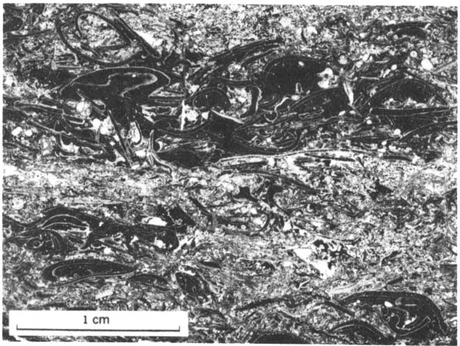
The Burlingame is composed mainly of two distinct types of limestone that were recognized previously by Moore (1936a, p. 216). The member contains thin claystone beds in places. The lower part of the Buringame is light- to medium-gray thin- to thick-bedded dense to very fine grained hard very fossiliferous limestone. At many localities the lower 0.2-1 foot of the member is very argillaceous and weathers to rubble. At several places the lowest bed contains very small subangular to subrounded dense limestone pebbles that are tightly cemented in the limestone matrix (fig. 8), On fracturing, the limestone breaks across the pebbles.
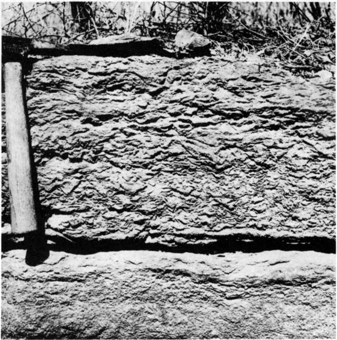
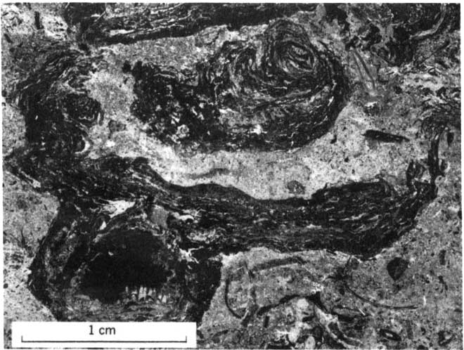
The upper part of the Burlingame is composed of irregular and generally elongate subangular to subrounded fragments of light- to medium-gray and light-brownish-gray very fine grained hard dense sparsely fossiliferous limestone in a matrix of dense or very fine grained argillaceous limestone (fig. 9) of the same color. The fragments may be jumbled or arranged in irregular layers and are generally alined with the convex sides down. The fragments have subconchoidal fracture, and each fragment generally is partly rimmed with a very thin dark colored algal (?) layer. The limestone is thin to thick bedded and partly argillaceous and locally contains pyrite and very small calcite-filled geodes. The weathered limestone is mottled light olive gray and pale yellowish brown and has fragments weathered in relief on its exposed surfaces (fig. 10). The brecciated limestone composes most of the member north of the Kansas River.
Figure 8--Conglomeratic limestone in basal part of Burlingame Limestone Member of Bern Limestone. Light-colored fragments are limestone; many darker fragments are algal-coated fossil debris. NW NW sec. 34, T. 11 S., R. 14 E. Vertical peel print, courtesy of D.E. Owen.
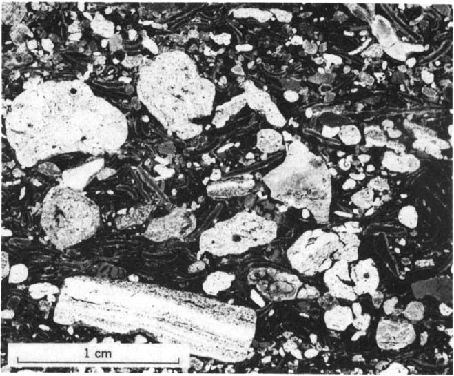
Figure 9--Brecciated part of Burlingame Limestone Member of Bern Limestone from quarry in SE NE sec. 29, T. 10 S., R. 15 E. Note dark algal (?) layer beneath limestone fragments. Light-colored matrix is dense limestone. Black spots are air bubbles. Vertical peel print, courtesy of D.E. Owen.
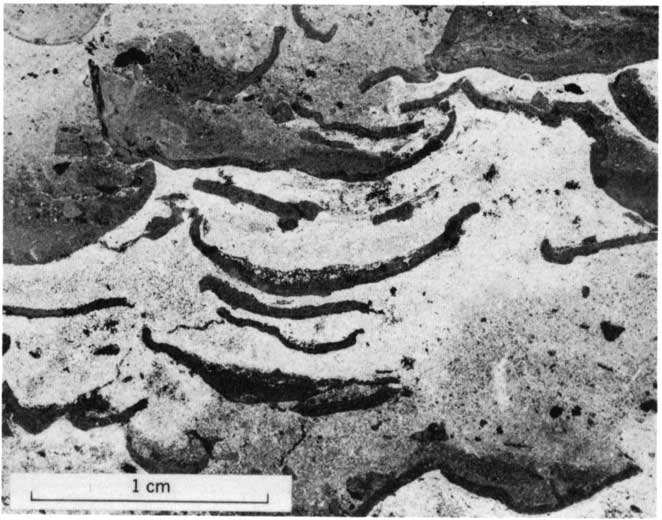
Figure 10--Weathered brecciated part of Burlingame Limestone Member of Bern Limestone in roadcut in NW NE sec. 36, T. 10 S., R. 14 E.
An olive-gray and yellowish-gray calcareous sparsely fossiliferous claystone occurs in the lower or middle part of the Burlingame along Blacksmith Creek (strat. section 4) and north of the Kansas River east of Messhoss Creek. This claystone is 0.1-9.7 feet thick, laminated to very thin bedded, and locally slightly silty to sandy. Very thin claystone partings also occur in the Burlingame at some localities south and east of Auburn.
The Burlingame Limestone Member has been eroded from a small area along the Kansas Turnpike in the center of the W2 sec. 17, T. 13 S., R. 15 E., by a channel deposit tentatively assigned to the Soldier Creek Shale Member of the Bern.
The Burlingame contains three fossil zones, but all three zones are not present everywhere (Moore, 1936a, p. 217; Owen, 1959). The basal 1-2 feet of the member throughout much of the east-central part of the area is characterized by abundant pelecypods, particularly Aviculopecten, small gastropods, brachiopods, and the alga, Osagia. Less abundant are crinoid stems, ramose and fenestrate bryozoans, and fusulinids. Much of the fossil debris is very small.
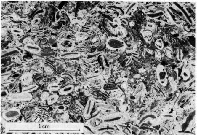
Overlying the mollusk zone and comprising the entire member at many localities south of the Kansas River is a zone characterized by abundant fusulinids and Osagia (fig. 11). Generally the fusulinids increase in abundance upward in the zone, and the Osagia are more abundant in the lower part and sparse to absent in the upper part. Brachiopods are abundant and varied; crinoid stems, ramose and fenestrate bryozoans, and gastropods are numerous; and pelecypods and Cryptozoon-like algae occur at some localities.
Figure 11--Burlingame Limestone Member of Bern Limestone. Granular texture is due to presence of dark-colored fossil debris coated with light-colored Osagia algae. SE NE sec. 27, T. 13 S., R. 14 E. Vertical peel print, courtesy of D.E. Owens.
The upper fossil zone--the brecciated limestone--contains a sparse fauna of crinoid stems, brachiopods, and gastropods and a few fusulinids and ramose bryozoans. Most of the fossils occur in the lower part of the brecciated limestone, E. L. Yochelson (written commun., 1960) reported Linoproductus prattenianus (Norwood and Pratten), Dielasma? sp. indet., and a pleurotomariacean gastropod from the brecciated limestone. The claystone bed contains a few fusulinids, crinoid stems, and brachiopods.
Soldier Creek Shale Member--The Soldier Creek Shale Member (Beede, 1898, p. 30) is 6.6-15 feet thick; it is thickest along the Kansas Turnpike south of Auburn. This member is mainly claystone with a lesser amount of limestone, but at places south of Auburn it is almost entirely limestone, Some beds of siltstone and sandstone occur in the southern part of the outcrop area, and a thin coal bed is present locally.
The claystone is mainly medium gray and olive gray, slightly silty to slightly sandy, noncalcareous to very calcareous, and laminated to thin bedded. At places it contains abundant small nodules of argillaceous limestone. The weathered claystone is light olive gray, yellowish brown, or olive brown. The very calcareous claystone commonly weathers to hard yellowish-orange or grayish-orange platy or nodular rubble.
A very thin dark-gray to grayish-black claystone bed that may grade laterally into coal occurs near the base of the member in the SW NE sec. 11, T. 11 S., R. 14 E. A coal bed 0.3 foot thick is present about 10 feet below the top of the Soldier Creek Shale Member in the bank of Vassar Creek in the NW NW sec. 30, T. 11 S., R. 14 E.
One or more beds of light- to medium-gray and yellowish-orange very finely crystalline to fine-grained very argillaceous generally unfossiliferous limestone are present in the middle or upper part of the Soldier Creek Shale Member. The limestone is generally laminated to thin bedded and weathers to conspicuous grayish-orange or pale-yellowish-brown platy or nodular fragments and, locally, to boxwork. Commonly the limestone is interbedded with layers of claystone, and the contacts with the claystone beds are generally gradational. At some localities the limestone contains stringers and veinlets of brown calcite. Along the east edge of the area north of the Kansas River, the limestone in the Soldier Creek is very pyritic and fossiliferous.
South of Auburn the very argillaceous unfossiliferous limestone of the Soldier Creek grades fairly rapidly into a bioherm composed mainly of yellowish-gray to light-olive-gray finely to coarsely crystalline very thin to medium-bedded coquinoidal limestone. The bioherm, centered along the Shawnee County-Osage County line, is well exposed in the south bluff of South Branch Wakarusa River and along the Kansas Turnpike. According to Owen (1959, fig. 62), the bioherm trends northwestward and is about 5 miles long and more than 3 miles wide; its original width is unknown. It is thickest, 10.5 feet, along the Kansas Turnpike in the NW SW sec. 25, T. 13 S., R. 14 E, From there the reef wedges out within less than 1 mile to the northwest. The main-reef facies, exposed along the Kansas Turnpike, is characterized by coquinoidal limestone of unbroken or large fragments of fossils in a matrix of clear crystalline calcite (fig. 12), Owen (1959, p. 84) reported that the insoluble residue of the main-reef facies averages only about 1.5 percent and consists of sub angular to angular quartz sand, clay and silt aggregates, and a very small amount of muscovite. Locally along the Kansas Turnpike, a parting 0-1.5 feet thick of olive-gray to dark-gray calcareous pyritic claystone occurs in the lower part of the bioherm. The fore-reef facies, in the SE cor. NE sec. 34, T. 13 S., R. 14 E., is characterized. by very small fossil debris and by having considerably more clastic material, mainly subangular to angular quartz sand (Owen, 1959, p. 84), than the main-reef facies.
Figure 12--Main-reef facies of bioherm in Soldier Creek Shale Member of Bern Limestone in NW SW sec. 25, T. 13 S., R. 14 E. Vertical peel print, courtesy of D.E. Owen.
The reef limestone is generally overlain by dusky-yellow slightly sandy calcareous claystone. Locally, in the NE cor. SW sec. 35, T. 13 S., R. 14 E., however, the bioherm is overlain by a O.4-foot-thick light-brownish-gray limestone bed (possibly of algal origin), which, in turn, is overlain by a O.2-foot-thick dense limestone bed that weathers dark yellowish brown and that contains fusulinids. Above these beds is claystone, at the top of the member.
Siltstone in the Soldier Creek is mainly medium gray to light brownish gray and locally clayey or slightly sandy, laminated to platy, and unfossiliferous. Parts of it are calcareous and micaceous and contain yellowish-gray limestone nodules less than 0,1 foot to about 0.3 foot long. Near the Kansas Turnpike about 2 miles northeast of Auburn, a yellowish-gray very fine grained silty laminated micaceous limestone occurs at or near the base of the member.
Throughout most of the area the Soldier Creek rests conformably on the Burlingame Limestone Member. South of Auburn, however, an unconformity between the bioherm in the member and the underlying units is well exposed along the Kansas Turnpike, where, within a very short distance, the bioherm rests on claystone in the lower part of the Soldier Creek, on the eroded and weathered Burlingame, and on the upper part of the Silver Lake Shale Member of the Scranton Shale. Channel deposits tentatively assigned to the Soldier Creek rest on the Scranton Shale in the center of the W2 sec. 17, T. 13 S., R. 15 E., where the Burlingame is absent.
Except for the bioherm, the limestone beds in the Soldier Creek contain fossils only at a few localities near the Wakarusa River and near the Kansas River. Pelecypods are abundant, crinoid stems and brachiopods are fairly numerous, and Osagia and fusulinids are sparse, Locally the claystone bed beneath the Wakarusa Limestone Member of the Bern contains a few crinoid stems, and at one locality the basal part of the Soldier Crook contains carbonaceous material. The Soldier Creek bioherm is a profusion of mytiloid pelecypods and high- and low-spired and bellerophontid gastropods, Less abundant forms are fusulinids, crinoid stems, ramose bryozoans, and brachiopods. Nautiloid cephalopods and shark teeth are sparse.
Wakarusa Limestone Member--The Wakarusa Limestone Member (Beede, 1898, p. 30; Condra, 1927, p. 77) is about 1.7-4 feet thick and consists of two limestone beds separated by claystone. The member generally forms a narrow inconspicuous bench on the slope above the Burlingame Limestone Member, and at most places only the upper limestone crops out.
The limestone beds are typically medium light gray to medium gray or light olive gray and generally weather yellowish gray, olive gray, and yellowish brown. They are generally very fine grained, partly argillaceous, thin to thick bedded, hard, and compact. The lower bed is 0.5-1.3 feet thick, locally contains claystone interbeds in its uppermost part, and weathers to a single bed that is platy in its lower part. The upper bed is 1-2.8 feet thick, is commonly vertically jointed, and locally weathers to platy fragments on its upper surface.
The intervening claystone, 0.1-0.9 foot thick, is generally olive gray or medium gray, slIghtly to moderately silty, laminated to platy, and calcareous. It weathers light olive gray and pale to moderate yellowish brown and, at many localities, contains very thin beds of fossiliferous argillaceous limestone.
The fauna of the Wakarusa Limestone Member is abundant and varied and is generally more abundant in the upper limestone than in the lower. Typically, the lower limestone contains many Osagia, crinoid stems, and brachiopods. Small fusulinids are sparse to abundant in the upper part of the lower limestone. Less abundant are Cryptozoon-like algae, ramose and fenestrate bryozoans, and gastropods (fig. 13). Horn corals, pelecypods, and trilobites are sparse. The upper limestone is characterized by many large fusulinids, Cryptozoon-like algae, crinoid stems, and brachiopods. Horn corals, and ramose, fenestrate, and encrusting bryozoans are common, and Osagia, pelecypods, and gastropods are sparse. Cephalopods and possibly ostracodes are very sparse. E. L. Yochelson (written commun., 1960) reported that fusulinids (USGS colIn. f12974), possible algal growths, crinoid stems, and "Spiriferina" d. "S." kentuckensis (Shumard) are present in the Wakarusa in the NW sec. 31, T. 11 S., R. 15 E.
Figure 13--Cryptozoon-like algae in lower limestone bed of Wakarusa Limestone Member of Bern Limestone in SW NW sec. 23, T. 13 S., R. 14 E. Note algal-encrusted horn coral in lower left corner. Vertical peel print, courtesy of D.E. Owen.
Auburn Shale (strat. sections 4, 5)--The Auburn Shale (Beede, 1898, p. 30; Condra, 1927, p. 78) undoubtedly was named for Auburn, Kans., but Beede did not designate a type locality. The formation is well exposed along the Kansas Turnpike in the NE SW sec. 35, T. 13 S., R. 14 E., southwest of Auburn. The Auburn is widespread in the east half of the area, where it weathers to a fairly steep slope in which the thicker, more resistant limestone beds form benches.
The Auburn ranges in thickness from about 30 to 70 feet; it is about 60 feet thick at the south edge of the area, 48 feet thick west of Auburn, and 70 feet thick northeast of Auburn near Elevation School. Near the Kansas River the thickness is about 30-45 feet, and north of the river, 30-40 feet. The Auburn rests conformably on the Bern Limestone, and the contact between the two formations is sharp and even.
The Auburn consists mainly of claystone but includes much siltstone, especially in the southern part of the area, and lesser but about equal amounts of limestone and sandstone. The sandstone is also. restricted to the southern part. The claystone is light olive gray, olive gray, medium gray, and medium dark gray; it weathers olive gray and yellowish brown. It is silty, laminated to. platy, partly calcareo.us, and micaceous; locally it contains small ironstone concretions and sandstone and limestone nodules. A bed 1-2.2 feet thick of medium-dark-gray to grayish-black silty finely laminated fossiliferous claystone underlain by a O.1-foot-thick grayish-black claystone that weathers to hard fissile plates occurs 11-13 feet below the top of the Auburn. These dark beds, together with the underlying light-colored claystone, form a conspicuous outcrop alo.ng the valley of Little Soldier Creek and along part of Soldier Creek. The dark claystone also crops out at a few localities south of the Kansas River.
Siltstone of the Auburn is mainly olive gray and yellowish gray and weathers light olive gray, yellowish gray, and moderate yellowish brown. Generally the siltsto.ne is clayey to sandy, laminated to platy, micaceous, and partly calcareous. The sandstone is typically yellowish gray, light greenish gray, and yellowish brown, very fine to fine grained, laminated to very thin bedded, and locally micaceous; commonly it is interbedded with siltstone, Some crossbedded layers and limonitic sandstone concretions occur locally.
The limestone is mainly medium gray, brownish gray, olive gray, and yellowish gray. The weathered limestone is generally the same color, but in some places it is yellowish brown and orange. The limestone is generally very fine grained, argillaceous, thin bedded, and very fossiliferous. In many places it has a granular appearance owing to abundant minute fossil fragments.
The limestone is generally restricted to two zones in the Auburn, but locally along Blacksmith Creek (strat. section 4) another zone as much as 10 feet of very argillaceous unfossiliferous limestone occurs near the middle of the Auburn. The lower zone is about 5-15 feet above the base of the formation. Limestone beds in this zone are thicker and more continuous north of the Kansas River than to the south, but some occur as far south as Shunganunga Creek (pl. 3). A massive limestone bed about 5 feet thick forms a prominent ledge or bench along the lower valley of Little Soldier Creek and in adjacent areas along Soldier Creek.
The upper zone of limestone occurs at the top of the Auburn at the south edge of the mapped area and about 10 feet below the top of the Auburn in the northern part of the area, where this zone overlies the grayish-black claystones discussed previously. The upper zone is as much as 9 feet thick and ranges from a single bed of limestone to a very calcareous claystone containing very thin beds of fossiliferous limestone. The limestone forms a prominent bench in the uppermost part of the Auburn Shale along the south side of the Wakarusa River southwest of Auburn. Large blocks of limestone are conspicious in the east wall of the valley of Little Soldier Creek in the N2 sec. 17, T. 10 S., R. 15 E. Limestone was fonnerly quarried from this zone along the north side of the Kansas River valley northeast of Silver Lake, in the NW NE sec. 10, T. 11 S., R. 14 E., and south of the river in the NW SE sec. 35, T. 11 S., R. 14 E, (strat. section 5).
Most limestone of the Auburn Shale contains abundant Osagia, crinoid stems, ramose and fenestrate bryozoans, brachiopods, pelecypods (especially myalinid-types), and low-spired and bellerophontid gastropods, Some beds are composed almost entirely of Osagia. The claystone, particularly in the upper part, is fossiliferous. The grayish-black claystone contains many Lingula. Finely comminuted carbonaceous material and some larger plant remains occur locally in sandstone and at a few places in claystone in the lower part of the Auburn.
Emporia Limestone (strat. sections 4, 5) The Emporia Limestone (Kirk, 1896, p. 80; Condra, 1927, p. 78) contains, in ascending order, the Reading Limestone, Harveyville Shale, and Elmont Limestone Members. It has a narrow dendritic outcrop pattern over the eastern third of the area (pl. 3) and forms a low escarpment or hillside bench. The Emporia is 8-20 feet thick and confonnably overlies the Auburn Shale. At most localities the contact is sharp; elsewhere it is slightly gradational. The contacts between the members of the Emporia are sharp and conformable.
Reading Limestone Member--The Reading Limestone Member (Smith, 1905, p. 150), 1.3-4.6 feet thick, is commonly made up of two or three beds of light-olive-gray and medium-light-gray to medium-gray finely crystalline and very fine grained limestone. It is slightly argillaceous in part and is thin to thick bedded, hard, and compact. The Reading has subconchoidal fracture and in places contains small inclusions of light-red celestite. Most of the member weathers mottled light olive gray, moderate yellowish brown, and dark yellowish orange and forms a ledge broken by conspicuous vertical joints. The zone of weathering extends deep into the rock. At some localities the limestone is more argillaceous adjacent to bedding planes, and at one place light-olive-gray slightly calcareous claystone 0.2 foot thick occurs near the middle. The upper limestone is 0.3-0.6 foot thick, is more argillaceous than the underlying beds and characteristically forms an indentation on the outcrop. Its upper surface is commonly pitted and markedly iron stained.
The Reading Limestone Member characteristically has many crinoid columnals that weather white and in relief. Brachiopods, particularly Chonetes and productoids, are abundant, and large and small fusulinids are abundant to sparse. Osagia, ramose, fenestrate, and encrusting bryozoans, and gastropods are common; pelecypods occur in the basal part at some localities, Cryptozoon-like algae, echinoid plates, and horn corals are also present locally. Fusulinids are generally absent in the uppermost bed.
Harveyville Shale Member--The Harveyville Shale Member (Moore, 1963a, p. 226) ranges in thickness from 4.3 to 15 feet and averages about 10 feet. The Harveyville is mainly light-olive-gray laminated to platy partly silty claystone. In places the claystone contains thin siltstone partings that weather moderate yellowish brown. Very small nodules of light-olive-gray fine-grained limestone and of very fine grained sandstone and small concretions of moderate-yellowish-brown ironstone are abundant locally.
Thin beds of medium-light-gray and pale-red very fine grained partly argillaceous limestone are present at many localities. The member contains a few beds of medium-gray and olive-gray clayey to sandy laminated to platy siltstone, mainly in the southern part of the area.
Fossils are sparse in the Harveyville and are confined almost entirely to the limestone beds, although they do occur locally in claystone and siltstone beds near the top. The most common forms are crinoid stems, brachiopods, and pelecypods. Fusulinids and a few Osagia (?) and Cryptozoon-like algae are present locally. Spirorbis sp. indet., ostracodes, and the fern Neuropteris cf, N. scheuchzeri Brongniart were found in the center of the N2 sec. 25, T. 11 S., R. 13 E. (E. L. Yochelson, written commun., 1960).
Elmont Limestone Member--The Elmont Limestone Member (Beede, 1898, p. 30), 2.5-5.2 feet thick, consists of two beds of limestone, which are separated at many localities by a thin unit of claystone. The lower limestone, 0.7-3.2 feet thick, is generally medium light gray, light olive gray, and pale yellowish brown and is very fine grained to very finely crystalline. It is very thin to medium bedded, clayey to sandy in places, and commonly coquinoidal. The limestone weathers light olive gray, yellowish gray, and pale yellowish orange and commonly has a granular texture caused by abundant minute fossil fragments. Light-red to moderate-reddish-orange celestite nodules are sparse to moderately abundant in many outcrops. A claystone parting 0.8-1.2 feet thick locally occurs in the lower limestone along Blacksmith Creek and northwest of Auburn. This parting is light olive gray and calcareous and in places contains nodules of very light gray limestone. In part of the areaespecially near the south boundary-the lower limestone is conglomeratic, as previously noted by Moore (1936a, p. 227), and contains subangular to subrounded granules and pebbles of medium-gray to medium-dark-gray limestone. The granules and pebbles are generally less than 0.02 foot in diameter, but a few are as much as 0.1 foot.
The middle unit is 0.4-0.8 foot thick at most places, but locally, it is as much as 2 feet thick. It is medium-light-gray to medium-gray and light-olive-gray partly calcareous claystone and, locally, siltstone. At a few places the claystone contains ironstone concretions, some as much as 0.3 foot thick and 0.8 foot long.
The upper limestone, 0.8-2 feet thick, is the most resistant and most characteristic part of the Elmont. It consists of medium-light-gray to medium-gray and brownish-gray very fine grained hard compact limestone that has subconchoidal fracture and breaks with a sharp ringing sound. It weathers yellowish gray, yellowish orange, and yellowish brown and forms a vertically jointed ledge. Commonly the upper few inches of the limestone is moderately argillaceous and weathers to thin platy fragments. "Cable markings" are conspicuous on some weathered outcrops.
The distinct faunal assemblages in the Elmont Limestone Member aid in its identification. The lower unit is commonly coquinoidal limestone containing abundant Osagia, crinoid stems, brachiopods, and pelecypods. Ramose and fenestrate bryozoans are common, and fusulinids, Cryptozoon-like algae, and gastropods occur at some localities. The middle claystone unit is generally sparsely fossiliferous, but in places it appears to be unfossiliferous. Fusulinids, crinoid stems, bryozoans, brachiopods, pelecypods, and gastropods are included in the fauna of the middle unit. The upper limestone unit of the Elmont is characterized by abundant, generally small, fusulinids, crinoid stems, and brachiopods, Ramose, fenestrate, and encrusting bryozoans and gastropods are common. Cryptozoon-like algae, horn corals, and pelecypods are present at a few localities. The fossil fragments in the upper bed are generally reddish brown, probably owing to a coating of the alga Osagia. E. L. Yochelson (written commun., 1960) identified the following forms from the upper limestone unit:
USGS fossil locality 19458-PC (f12972). Along a gully in the SE SW sec. 23, T. 10 S., R. 14 E.
Fusulinids, undet.
Crinoid stems
Rhomboporoid bryozoan fragment
?Derbyia sp. indet.
Crurithyris cf. C. planoconvexa (Shumard)
"Spiriferina" kentuckensis (Shumard)
Pelecypod, indet.
Bellerophon cf. B. singularis Moore
Glabrocingulum (Ananias) marcouianus (Geinitz)
Paleostylus (Pseudozygopleura) scitula (Meek)
"Strobeus" sp. indet.
Donaldina sp. indet.
Willard Shale (strat. sections 4, 6)--The Willard Shale was named by Beede (1898, p. 31) after the village of Willard, south of the Kansas River on the Shawnee County-Wabaunsee County line, and it is well exposed in cutbanks along Post Creek south of the village (pl. 3). The Willard forms a fairly steep partly covered slope between the bench formed by the Emporia Limestone (below) and the ledge or escarpment formed by the Zeandale Limestone (above). The contact between the Willard and the Emporia Limestone is sharp and conformable.
The Willard is about 14-56 feet thick, and locally there is a wide variation in thickness. The formation is about 40 feet thick just south of the mapped area, in the center of the NE sec. 3, T. 14 S., R. 14 E., and 30 feet thick less than 1 mile to the northwest, at the SE cor. sec. 33, T. 13 S., R. 14 E. Along the Wakarusa River valley about 2 miles north of the latter locality, the Willard is approximately 15 feet thick. Maximum thickness, 56 feet, occurs north of the Kansas River in the SW sec. 23, T. 10 S., R. 14 E.
Most of the Willard is composed of claystone and siltstone except south of the Wakarusa River, where the formation is mostly sandstone; elsewhere, thin sandstone beds occur only in the upper part of the formation. The claystone is olive gray to medium gray and weathers light olive gray and yellowish brown. It is commonly silty, is laminated to platy, and in places contains thin beds of ironstone concretions that weather dark yellowish orange to moderate yellowish brown.
The siltstone is typically olive gray and yellowish gray, clayey, laminated to p1aty, and finely micaceous; it w.eathers light olive gray to moderate yellowish brown. In many places the siltstone is interbedded with sandstone or claystone. Commonly, hard fragments of siltstone and ironstone concretions are present on the weathered outcrop. The sandstone is light olive gray and light gray, very fine grained, silty, laminated to platy, and micaceous; it weathers mainly light grayish yellow and pale yellowish brown. A very thin coaly streak occurs about 4 feet below the top of the Willard along Haskell Creek in the NE cor. SE NW sec. 31, T. 12 S., R. 14 E.
The Willard Shale is generally unfossiliferous, but at a few localities brachiopods are abundant in the basal part, and fusulinids, crinoid stems, brachiopods, and a few pelecypods and gastropods occur in the uppermost part. Coal material and carbonized plant fragments occur locally in the upper part.
Zeandale Limestone (strat. section 6)--The Zeandale Limestone (Moore and Mudge, 1956, p. 2276) is composed, in ascending order, of the Tarkio Limestone, Wamego Shale, and Maple Hill Limestone Members. The formation crops out in a broad north-south-trending band, generally through the middle of the the area. The lower limestone member underlies a prominent escarpment, and the two upper members underlie grassy slopes and are poorly exposed. Along the Wakarusa River (pl. 3) the upper half of the Zeandale is absent owing to channeling. The formation is about 18-25 feet thick, but southwest of Auburn it is locally about 40 feet thick. The Zeandale conformably overlies the Willard Shale, and the contact between the two members is sharp and slightly irregular.
Tarkio Limestone Member--Tarkio Limestone Member (Calvin, 1901, p. 420; Condra and Bengston, 1915, p. 8) forms a prominent ledge that is broken by widely spaced vertical joints; large limestone blocks break from the ledge and slump onto the underlying slope. The Tarkio ranges in thickness from 2 feet to 13 feet near Dover. The member is a single limestone unit in most places, but locally it comprises two limestones and a medial claystone.
The Tarkio is composed primarily of one type of limestone, but from the Kansas River south almost to Dover a different type of limestone occurs in the upper part. Light-gray to pale-yellowish-brown very finely crystalline thin-bedded to massive limestone is the dominant lithology; it composes the lower and thicker part of the member, and throughout most of the area it constitutes the entire member. This limestone is generally slightly argillaceous but is locally more argillaceous in its basal part. In the area south of the Wakarusa River, the lower part is moderately sandy. The limestone contains a high percentage of iron oxide and characteristically weathers moderate yellowish brown. In places the lower limestone weathers grayish orange to dark yellowish orange. Where the member is thick bedded or massive, it forms large rectangular blocks; but where it is thin bedded, it weathers to wedge-shaped slabs and has a wavy-bedded appearance. Commonly the upper 1-2 feet of the member is porous, and the upper surface is irregular and pitted. Abundant large fusulinids characteristically stand in relief on the weathered surfaces. Locally, small nodules of light-red to moderate-reddish-orange celestite occur in the upper part.
Medium-light-gray to medium-gray and pale-brown very fine to fine-grained locally argillaceous very thin bedded to massive limestone composes the upper 0.6-5.7 foot of the Tarkio from the Kansas River southward to the vicinity of Dover, especially along Mission Creek valley. In most places the limestone has a pseudo-oolitic texture owing to the presence of finely comminuted algal-coated fossil fragments. Locally along Mission and Haskell Creeks (pl. 3) the basal part of this limestone is sandy. The upper limestone weathers to light-gray, yellowish-gray, and pale-yellowish-brown surfaces that are rough, porous, and deeply pitted. The light-colored porous upper limestone contrasts markedly with the lower dark-colored limestone of the Tarkro.
At most localities the upper limestone rests directly on the lower limestone. At places the contact is sharp and irregular, but elsewhere it is gradational. Locally along Mission and Haskell Crooks, however, a bed 0-3.2 foot thick of light-olive-gray calcareous generally fossiliferous claystone separates the two limestones. Brown limestone nodules less than 0.06 foot in diameter occur in the claystone.
The dominant limestone of the Tarkio is characterized by the large robust fusulinid Triticites ventricosus Meek and Hayden (Moore, 1936a, p. 230). Fusulinids from this unit are in USGS foraminiferal collection f12970 from a roadcut in the NW cor. SE sec. 27, T. 10 S., R. 13 E., near Rossville. At some localities brachiopods, especially Reticulatia, and crinoid stems are common. Horn corals and ramose bryozoans occur in many places, and gastropods and encrusting and fenestrate bryozoans were noted Tht several localities. The basal part of the Tarkio contains some pelecypods, and the middle part, some Cryptozoon-like algae.
The upper limestone of the Tarkio is characterized by abundant Osagia. Cryptozoon-like algae, crinoid stems, ramose and fenestrate bryozoans, brachiopods, pelecypods, and gastropods are common. Large fusulinids are present but seldom abundant. Arenaceous foraminifers dominate the coarse fraction of the insoluble residues, according to Wood (1959, p. 76).
Wamego Shale Member--The Wamego Shale Member (Condra and Reed, 1943, p. 42) is about 9-16.5 feet thick throughout most of the area, but locally south of the Wakarusa River (pl. 3) it is 30-35 feet thick. The member is mostly claystone but contains some siltstone, sandstone, and nodules and several thin beds of argillaceous limestone. The claystone is mainly light olive gray to medium gray, slightly to moderately silty, and finely laminated to platy; in places it is also partly micaceous and very calcareous. It weathers very light gray, light olive gray, and yellowish gray. Commonly, light-olive-gray and moderate-yellowish-brown micaceous siltstone is interbedded with the claystone. In places the outcrop is covered with hard fragments of iron-stained siltstone.
A limestone bed generally 0.3-2.2 feet thick but locally as much as 6 feet thick occurs 2-8 feet above the base of the Wamego at many localities. The limestone is light olive gray and shades of brown, cryptocrystalline to very fine grained, moderately to very argillaceous, very thin to medium bedded, and fossiliferous. In Cross Creek in the SW NE sec. 15, T. 10 S., R. 13 E., the limestone is about 6 feet thick and is interbedded with claystone. Some of the limestone layers contain small limestone pellets. Thin beds of limestone also occur in the Wamego near the Wakarusa River. Sandy micaceous wavy-bedded limestone 3 feet thick is exposed in roadcuts in the west-central part of sec. 18, T. 10 S., R. 15 E. Fossils in this bed are confined to the upper half.
Dusky-yellow to yellowish-gray very fine grained micaceous sandstone occurs locally in the Wamego near the Wakarusa River. A coaly streak is present in the uppermost part of the member about 1.5 miles south of Willard; at a few other localities the claystone in that part of the member is coaly and carbonaceous.
Near the Wakarusa River, channel deposits of the Onaga (?) Shale rest unconformably on the middle part of the Wamego (pl. 3). Because the two rock types are similar in lithology, the position of the contact between them is questionable.
Limestone beds of the Wamego generally are moderately fossiliferous, and some of the claystone beds are sparsely fossiliferous. Brachiopods, ramose and fenestrate bryozoans, and crinoid stems are common to abundant in the limestone beds; Osagia, pelecypods, and gastropods are less numerous. The claystones locally contain abundant crinoid stems and pelocypods and a few gastropods, ostracodes, plant fragments, and worm tracks.
Maple Hill Limestone Member--The Maple Hill Limestone Member (Condra, 1927, p. 80) is present in the outcrop belt of the Zeandale Limestone except near the Wakarusa River (pl. 3), where it has been eroded by a channel. The member is a very uniform and persistent limestone 1.2-2 feet thick. It is light to medium gray, very fine grained, very thin to medium bedded, and hard, Characteristically, it weathers to a single bed that is mottled light olive gray, moderate yellowish brown, and grayish orange and separates along joints into large rectangular blocks. The upper surface is rough, is mottled with grayish-red and dark-brown iron stain, contains small hard limonitic concretions in some places, and weathers to angular chips. At places the lower 0.2 foot is argillaceous and weathers to platy fragments.
The Maple Hill Limestone Member is characterized by abundant slender fusulinids, crinoid stems, and brachiopods, Ramose bryozoans and gastropods are common; and Osagia, horn corals, pectenoid pelecypods, possibly ostracodes, and a few trilobites occur at some localities. Cryptozoon-like algae are locally abundant in the upper part of the member.
E. L. Yochelson (written commun., 1960) identified the following forms:
USGS fossil locality 19459-PC (f12965). In a gully in the N2 SE sec. 2, T. 10
S., R. 14 E.
Ailgae (Cryptozoon-like)
Fusulinids, undet.
Crinoid stems
Astartella sp. indet.
Streptacis? sp. indet.
Fossil locality in stream in the SW cor. sec. 32, T. 13 S., R. 14 E.
Fusulinids, undet. (abundant) (USGS colln. f12966)
Crinoid stems
Fenestrate bryozoan fragment
Meekella cf. M. striatocostata (Cox)
Lissochonetes? sp. indet.
Amphiscapha (Amphiscapha) sp. indet.
Trilobite pygidium, indet.
Fusulinids from the Maple Hill also are in USGS foraminiferal collection f12969 from a roadcut in the NW cor. SE sec. 27, T. 10 S., R. 13E.
Pillsbury Shale (strat. section 8)--The Pillsbury Shale (Moore and Mudge, 1956, p. 2275) is rather poorly exposed in a broad outcrop generally along the north edge and in the west half of the area. The Pillsbury is about 33 feet thick at the Shawnee County-Osage County line, about 61 feet thick east of Dover, and about 40 feet thick at the north edge of the area along Dutch Creek.
The Pillsbury conformably overlies the Maple Hill Limestone Member of the Zeandale Limestone, and the contact is sharp and even. Along the Wakarusa River near Dover and locally along the west boundary of the area south of U.S, Highway 40, all or part of the formation was eroded in channels of Late Pennsylvanian and Early Permian age (pl. 3). The upper part of the Pillsbury is cut by channels in a small area around the common corner of secs. 27, 28, 33, and 34, T. 9 S., R. 14 E., and there the Root Shale lies directly on the Pillsbury.
The Pillsbury is primarily interbedded siltstone and claystone but includes some sandstone and, locally, limestone. The siltstone is dominantly yellowish gray and olive gray and laminated to very thin bedded; it weathers yellowish gray and olive gray mottled with yellowish brown and olive brown. The siltstone is clayey to finely sandy and micaceous; where it is ferruginous, it weathers to hard moderate-yellowish-brown layers. The claystone is light olive gray to olive gray and medium gray to medium dark gray, silty, and laminated to platy; in places it contains nodules and lenses of very argillaceous limestone. The weathered claystone typically is light olive gray.
The sandstone, which is generally confined to the upper third of the formation, is light olive gray and yellowish gray, very fine grained, silty, laminated to thin bedded, and micaceous. It weathers to colors similar to those of the fresh rock. Locally the sandstone is slightly crossbedded and ripple marked and contains hard nodules and lenses of pyritic sandstone that weather moderate yellowish brown. At most localities the sandstone is interbedded with siltstone or claystone, Nodules, lenses, and a few hard concretionary beds of light-olive-gray, light-gray, and light-greenish~gray argillaceous partly micaceous limestone occur in the upper part of the Pillsbury. Very thin beds of ironstone concretions that weather dark yellowish orange to reddish brown are common in the lower part.
Fossils are sparse in the Pillsbury Shale and are mainly confined to the uppermost part. Fusulinids, crinoid fragments, and brachiopods are generally the most abundant. Ramose, fenestrate, and encrusting bryozoans, echinoids spines and plates, and pelecypods are also present. Finely comminuted carbonaceous material occurs on bedding planes, particularly in the sandstones and siltstones; and large plant impressions have been found in a sandstone about 10 feet below the top of the formation in the bank of Dutch Creek in the SE SW sec. 21, T. 9 S., R. 14 E.
Stotler Limestone (strat. sections 7, 8, 10)--The Stotler Limestone (Moore and Mudge, 1956, p. 2275) contains, in ascending order, the Dover Limestone, Dry Shale, and Grandhaven Limestone Members. The formation forms a conspicuous bench or low escarpment throughout much of its outcrop area, particularly south of the Kansas River (pl. 3). Its maximum thickness is about 23 feet, on the south side of the Wakarusa River along the line between T. 13 S., R. 13 E., and T. 13 S., R. 14 E.; its minimum thickness is about 5 feet, approximately 2 miles north of Rossville.
Near U.S. Highway 40 in the northeastern part of Wabaunsee County, the Dry Shale Member of the Stotler is very thin; it was mistakenly identified by Mudge and Burton (1959, p. 27-28, 198-199) as the Friedrich Shale Member of the Root Shale. Consequently, in that area they included beds that are properly in the Dry Shale and Grandhaven Limestone Members of the Stotler with the Dover Limestone Member and miscorrelated the Jim Creek Limestone Member of the Root with the Grandhaven.
The Stotler Limestone conformably overlies the Pillsbury Shale. At many localities the contact is gradational through a few inches of very calcareous claystone or very argillaceous limestone; elsewhere the contact is sharp and even. The members of the Stotler are conformable, and at places the contacts between them are slightly gradational. Near Dover and in the upper reaches of the Wakarusa River, younger Pennsylvanian and Early Permian channeling eroded the Stotler (pl. 3). The formation was also channeled out in a small area around the common corner of secs. 27, 28, 33, and 34, T. 9. S., R. 14 E.
Dover Limestone Member--The Dover Limestone Member was named by Beede (1898, p. 31) from unidentified exposures in the vicinity of Dover in the southwestern part of the area. Because no specific locality was stated as the type locality, and because channel-fill sandstone of younger age occupies the stratigraphic position of the Dover near the village, a reference locality in a roadcut in the SW NW sec. 31, T. 12 S., R. 14 E., 1.5 miles east of Dover, is hereby designated (strat. section 10). The Dover forms a prominent light-colored bench covered with cobbles and platy fragments of limestone.
The Dover is 1-4.8 feet thick and consists principally of light-olive-gray and light-gray moderately to very argillaceous thin- to thick-bedded partly pyritic hard limestone. In a few exposures it is medium gray and light olive brown. The limestone generally is very fine grained. The basal few inches and roughly the upper half are commonly very argillaceous; at many localities the bedding is irregular and obscure. The weathered limestone is dominantly light olive gray, light gray, and yellowish gray mottled in part by yellowish brown, yellowish orange, and brownish gray.
The lower part of the Dover commonly forms a vertically jointed ledge that weathers to irregularly shaped blocks; the blocks, in turn, may break into platy fragments. At places the lowermost part of the ledge weathers soft and platy. The upper, argillaceous part of the Dover characteristically weathers to nodular rubble owing largely to the presence of resistant algal masses, Many of the cobbles and blocks are pitted. In the center of the E2 SW sec. 21, T. 11 S., R. 13 E., a bed 0.5-1.2 feet thick of mottled olive-gray and light-yellowish-brown clayey to finely sandy calcareous siltstone containing many inclusions of sandy limestone occurs in the lower part of the Dover, very thin partings of siltstone and claystone are present at a few localities.
The Dover is characterized by large fusulinids, biscuit-shaped algal deposits, and brachiopods. The fusulinids are very abundant in the lower half of the member and less abundant to locally sparse in the upper half. Also in the lower half are many brachiopods, especially near the base, and crinoid stems. Less abundant fossils are ramose, rhomboporoid, encrusting, and fenestrate bryozoans, and horn corals. Osagia, a few tabulate corals, echinoid fragments, pelecypods, cephalopods, and trilobites are also present. Cryptozoon-like algae are the dominant fossils in the upper part; but fusulinids, crinoid columnals, horn corals, and brachiopods are common, and a few Osagia and ramose bryozoans are also present. The siltstone in the Dover contains fusulinids, crinoid columnals, brachiopods, and a few pelecypods. E. L. Yochelson (written commun., 1960) reported the following forms from the Dover:
USGS fossil locality 19460-PC (f12964). In a streambank in the NW SW SW sec. 30, T. 9 S., R. 14 E.
Fusulinids, undet. (abundant)
Trilobite (cf. Ditomopyge? sp.)
Fossil locality along U.S. Highway 40 in the SW SW sec. 30, T. 11 S., R. 13
E., 1 mile west of mapped area.
Algae (Cryptozoon)
Fusulinids, undet. (abundant) (USGS colln. fl2963)
Crinoid stems
Rhomboporoid bryozoan
Meekoporella? sp. indet.
Enteletes hemiplicatus (Hall)
Chonetes granulifer Owen
Fusulinids from the Dover are included in USGS foraminiferal collection f12962, from the bank of the Wakarusa River at the west line of the SW SW sec. 24, T. 13 S., R. 13 E. Derbyia? sp. indet. and a trilobite pygidium, indet., from that locality were also identified by Yochelson.
Dry Shale Member--The Dry Shale Member (Moore, Elias, and Newell, 1934) underlies covered slopes in the southern part of the area. In the northern part, where the member is very thin, it forms an inconspicuous reentrant between the underlying Dover Limestone Member and the overlying Grandhaven Limestone Member. The Dry has been eroded near Dover and, to the south, along the Wakarusa River in channels of La;te Pennsylvanian and Early Permian age (pl. 3). Near the north border of the area the member is almost 4 feet thick, but it thins to 0.1 foot near the Kansas River (strat. section 8). It is nearly 16 feet thick along the south side of the Wakarusa River.
The Dry is dominantly light-olive-gray to olive-gray silty platy partly calcareous claystone but includes some siltstone. It weathers light olive gray to olive gray mottled by light olive brown and moderate yellowish brown. At most localities the lower and middle parts contain abundant small irregular nodules of light-olive-gray and light-yellowish-gray hard dense argillaceous unfossiliferous limestone. The nodules weather light olive gray to light greenish gray mottled in part by light brownish gray, and they cover the outcrop.
Coquinoidal-limestone is present in the Dry Shale Member at several localities. In the SW NE sec. 6, T. 13 S., R. 14 E, (strat. section 7), a reeflike body as much as 2.5 feet thick contains beds that have an apparent dip of 3° SE and overlap progressively to the north, Here, the limestone is light olive gray to pale yellowish brown, very finely crystalline, thin bedded, and irregular; it contains many round argillaceous limestone pellets 0.01-0.02 foot in diameter, Coquinoidal-limestone, of which 3.5 feet is exposed, occurs on the east side of the road in the SW NW sec. 23, T. 12 S., R. 13 E., but it does not contain limestone pellets. Lenses as much as 0.1 foot thick of coquinoidal-limestone containing abundant pellets of argillaceous limestone occur in the Dry just west of the mapped area, along U.S. Highway 40 (strat. section 8), and lenses of fossiliferous limestone also crop out along the lower valley of Cross Creek north of Rossville.
Fossils are very sparse or absent in the Dry Shale Member except in the vicinity of the Kansas River and at the few localities where the member contains coquinoidal limestone. Crinoid columnals, ramose and fenestrate bryozoans, brachiopod shells, productoid spines, and pelecypods are abundant near the Kansas River; but elsewhere only a few brachiopod spines and pelecypods occur, and these, locally at the top of the member. The coquinoidal-limestone contains very abundant pelecypods and gastropods, many crinoid columnals, and, at places, Osagia.
Grandhaven Limestone Member--The Grandhaven Limestone Member was named by Moore, Elias, and Newell (1934), and the type locality was designated by Moore (1936a, p. 237) as sec. 31, T. 13 S., R. 14 E., near the abandoned post office of Grandhaven, in southwestern Shawnee County. The member was defined as a lower fusulinid-bearing limestone unit separated from an algal limestone by 4-10 feet of shale (Moore, 1936a, p. 237). The fusulinid-bearing limestone occurs throughout western Shawnee County and vicinity, but the algal limestone only occurs locally from near Dover southward into Osage County (O'Conner, 1955, p. 9). Consequently, the authors of this report have mapped the algal limestone and the intervening shale with the overlying Friedrich Shale Member of the Root Shale.
In the southern part of the area, where the underlying Dry Shale Member generally is thick, the Grandhaven forms a minor bench on the back slope of the low escarpment formed by the entire Stotler Limestone. Where the Dry is thin, the outcrop of the Grandhaven coalesces with that of the underlying Dover Limestone Member. The Grandhaven is absent owing to channeling in later Pennsylvanian and Early Permian time over parts of the area, primarily near Dover (pl. 3).
The Grandhaven Limestone Member of this report is 1.2-6 feet thick and throughout most of the area consists of two limestones separated by a thin claystone. Near the Kansas River and to the north, however, the member is a single limestone bed and commonly has claystone partings in the basal 1 foot. The lower limestone, 0.5-2.1 feet thick, is mainly light olive gray to medium light gray, very fine grained to very finely crystalline, slightly to very-argilaceous, thin to medium bedded, and hard. It commonly weathers light olive gray and yellowish gray mottled with yellowish brown and reddish brown. Locally it has dark-brown rough ferruginous masses on its upper surface. The upper limestone is 0.5-3 feet thick and averages slightly less than 1 foot in thickness. It is mainly light olive gray to olive gray and grayish orange, very fine grained, in part argillaceous, and very thin to thin bedded, Commonly it weathers olive gray and yellowish gray mottled with yellowish brown and orange. The upper limestone generally forms a single bed that is vertically jointed locally.
The intervening claystone of the Grandhaven is 0.2-1.9 feet thick and is light olive gray to olive gray, slightly to moderately silty, laminated, and calcareous. In places it contains thin lenses and small nodules of medium-light-gray, light-olive-gray, or brownish-gray very fine grained and very finely crystalline argillaceous limestone. The claystone weathers light olive gray to light olive brown and forms a reentrant between the limestone beds.
The Grandhaven contains an abundant and varied fauna including small slender fusulinids. Typically, the fusulinids are most abundant in the lower limestone, Generally fossils are abundant in the lower bed, but locally they are sparse, Crinoid stems and brachiopods are abundant, and ramose and rhomboporoid bryozoans and Osagia are generally present. Pectenoid and myalinid pelecypods and ostracodes (?) occur in the lower bed at a few localities. The middle claystone unit commonly contains crinoid stems and brachiopods and a few specimens of Osagia and ramose bryozoans. The upper limestone unit typically has abundant crinoid columnals, brachiopods, and, at many localities, Osagia. Fusulinids are locally abundant but at many places are apparently absent. Ramose bryozoans and productoid spines are common.
Root Shale (strat. sections 7, 8)--The Root Shale (Moore and Mudge, 1956, p. 2275) comprises, in ascending order, the Friedrich Shale, Jim Creek Limestone, and French Creek Shale Members. The Jim Creek Limestone Member was mapped in areas of good exposures. The Root is poorly exposed in the west half and along the north edge of the area. The formation is about 40-60 feet thick, averaging about 48 feet in thickness. The Root rests conformably on the Stotler Limestone, members of the Root are conformable, and locally the contacts between the members are gradational.
Friedrich Shale Member--The Friedrich Shale Member (Moore, Elias, and Newell, 1934) is 12-30 feet thick and averages 22 feet thick. As was discussed previously, the authors of this report mapped the upper algal limestone and intervening shale of the Grandhaven Limestone Member of the Stotler Limestone with the Friedrich in this area. The Friedrich is primarily claystone and siltstone, but it contains some limestone and a little sandstone. The claystone is light olive gray to olive gray, slightly to moderately silty, laminated to platy, and locally micaceous. Colors of weathered surfaces are similar to those of fresh surfaces except that in some places they include yellowish gray, pale yellowish brown, and light olive brown. A bed of mottled grayish-red and greenish-gray claystone commonly occurs in the lower few feet. Nodules and lenses of light-gray argillaceous limestone are abundant in the claystone at several localities. Ironstone concretions that weather pale to dark yellowish orange occur locally.
The siltstone generally is olive gray, clayey, platy, and finely micaceous; locally it is calcareous and pyritic. In many places it is interbedded with claystone. The siltstone weathers mainly moderate yellowish brown and forms hard iron-stained fragments.
A conspicuous bed 0.7-3.8 feet thick of light-gray to medium-light-gray very fine grained medium- to thick-bedded coquinoidal-limestone occurs at various positions within the Friedrich Shale Member at many localities from the vicinity of Dover southward into Osage County; this is the upper limestone of the original Grandhaven Limestone Member of the Stotler Limestone. Locally (strat. section 7) the bed contains abundant limestone (?) pellets less than 0.01 foot in diameter and a few small nodules of light-red barite. The limestone weathers to large light-olive-gray to light-brownish-gray blocks that appear banded, are porous, and show pit and cusp weathering on their upper surfaces. A 1-foot-thick bed of light-yellowish-brown sandy granular very fossiliferous limestone that weathers to nodular porous blocks occurs about 6 feet. below the top of the member in the NW sec. 4 and in the E2 sec. 9, T. 12 S.; R. 13 E.
Other types of limestone occur at several localities. A bed 0.9 foot thick of olive-gray to moderate-yellowish-brown very argillaceous sparsely fossiliferous limestone crops out in a small area near the south edge of the mapped area. This limestone is a few feet above the conspicuous grayish-red claystone in the basal part of the member. A thin bed of medium-light-gray to pale-yellowish-brown very finely crystalline limestone is present just below the top of the Friedrich along Soldier Creek in Jackson County.
The small amount of sandstone in the Friedrich is grayish yellow and yellowish gray with a brown or purple hue. It is fine grained and laminated to platy and at places is associated with thin beds of sandy limestone. A coal bed 0.2 foot thick occurs about 1 foot below the top of the member in the spillway of the dam at the Girl Scout camp about 2 miles south of Dover. Claystone containing abundant carbonaceous and coaly material occurs at the same stratigraphic position along the road in the SW SW sec. 31, T. 9 S., R. 14 E.
Most of the Friedrich Shale Member is unfossiliferous, but the conspicuous limestone bed south of Dover contains very abundant Osagia and pelecypods, many crinoid columnals and gastropods, and a few fusulinids. At a few places claystone in the uppermost part of the member contains crinoid stems, productoid brachiopods, and myalinid and pectenoid pelecypods. These fossils, as well as fenestrate bryozoans, also occur locally in sandstone beds. Lingula and gastropods are associated with the coaly and carbonaceous material near the top of the member. Very small shell fragments were found in the basal 1 foot at one locality, E. L. Yochelson (written commun., 1960) identified the following forms from the upper 1 foot:
USGS fossil locality 19461-PC. On the west line of the NW SW sec. 31, T. 9 S., R. 14 E., Jackson County.
Spirorbis sp. indet. (abundant)
Ostracodes, undet.
Jim Creek Limestone Member--The Jim Creek Limestone Member (Moore, Elias, and Newell, 1934) is seldom exposed because it is very thin, is nonresistant and lies between thick shale units. The best exposure of the limestone is along U.S. Highway 40 near the west edge of the area.
The Jim Creek, 0.4-2.4 feet thick, is light-olive-gray and medium-light-gray to medium-gray very fine grained very thin to mediumbedded hard limestone. The lower part is commonly argillaceous and weathers to a reentrant below the vertically jointed ledge formed by the upper part. Typically, the Jim Creek weathers mottled light olive gray to yellowish gray, pale to moderate yellowish brown, and dark yellowish orange. The upper surface contains hard dark-brown limonitic masses that weather out and leave pits. This upper surface commonly breaks into irregularly shaped chips. In the W2 sec. 31, T. 9 S., R. 14 E., and the E2 sec. 36, T. 9 S., R. 13 E., the Jim Creek is medium-light-gray coquinoidal-limestone that weathers to porous tabular blocks and closely resembles the coquinoidal-limestone in the Friedrich Shale Member near Dover.
The fauna of the Jim Creek Limestone Member is abundant and very diverse and aids in identification of the member. Brachiopods predominate and weather in relief. At most localities slender fusulinids are abundant, as well as crinoid stems; ramose, fenestrate, encrusting, and rhoroboporoid bryozoans; productoid spines; and myalinid, pectenoid, and other types of pelecypods, Osagia and gastropods occur in some places, and horn corals are sparse. The following collection from the Jim Creek was reported by E. L. Yochelson (written commun., 1960):
USGS fossil locality 19462-PO (f12959). In the NW SE sec. 6, T. 13 S., R. 14 E. (strat. section 7).
Fusulinids, undet.
Crinoid stems
Fenestrate bryozoans (worn)
Rhomboporoid bryozoans (worn)
Chonetes granulifer (Owen)
"Spiriferina" kentuckensis (Shumard)
Abundant shell fragments, some of which are pelecypod fragments
A. (Amphiscapha) cf. A. (A.) muricata (Knight)
High-spired gastropod, undet.
Dentalium? sp. indet.
At other localities Yochelson identified some of the fossils listed above and these additional forms:
Derbyia crassus (Meek and Hayden)
Marginifera wabashensis (Norwood and Pratten)
Reticulatia cf. R. huecoensis (R. E. King)
Crurithyris sp. indet.
Fusulinids from the Jim Creek are also retained in USGS foraminiferal collections f12958, from the SW cor. sec. 18, T. 10 S., R. 13 E.; f12960, from a roadcut on the east line of the SE sec. 17 T. 10 S., R. 13 E.; and f12961, from a roadcut on U.S. Highway 40 in the SW SE sec. 29, T. 11 S., R. 13 E.
French Creek Shale Member--The French Creek Shale Member (Moore, Elias, and Newell, 1934) generally is poorly exposed. All or part of the member is absent from many places near Dover and along the upper reaches of the Wakarusa River owing to channeling in later Pennsylvanian and Early Permian time.
The French Creek is 19-29 foot thick and consists mainly of siltstone and sandstone, which in places are interbedded. The Lorton coal bed occurs in the upper part of the member. The siltstone is light olive gray, yellowish gray, and light to medium gray, clayey to finely sandy, generally laminated to platy, and micaceous. It is partly pyritic and carbonaceous and contains some ironstone concretions. The siltstone weathers olive gray and yellowish gray mottled with moderate yellowish brown and locltlly forms hard iron-stained chips.
The sandstone is mainly light gray to medium light gray and olive gray, very fine grained, generally laminated to very thin bedded, and micaceous. Some is calcareous and forms hard concretionary partly crossbedded layers. Weathered colors are mainly shades of yellowish brown. The sandstone in the NE NW sec. 33, T. 9 S., R. 13 E., is very fine to fine grained and is mainly quartz, but calcite, muscovite, chlorite, feldspar, tourmaline, zircon, garnet, and an opaque mineral are common (Mudge, 1956, table 1).
The Lorton coal bed, 0.2-0.6 foot thick, is present in the upper several feet of the French Creek at most localities and in a few places is underlain by 0.3-0.6 root of light-gray underclay. In some areas It second and generally thinner coal bed occurs 1.5-6.5 feet below the Lorton. Medium-light-gray to medium-gray silty micaceous carbonaceous iron-stained claystone is commonly associated with the cod beds. Light-olive-gray to medium-gray si1ty claystone is interbedded with siltstone in the lower part of the member at places. In a few exposures very thin fragments of light-gray argillaceous limestone occur in the basal part of the French Creek.
The French Creek Shale Member is almost barren of fossils. Finely comminuted carbonized plant fragments occur in some beds. At several localities the shales between the coals and mudstone at the top of the member contain abundant megafossils, chiefly brachiopods and pelecypods but also crinoid stems, productoid spines, and ramose and fenestrate bryozoans.
Wood Siding Formation (strat. section 7)--The Wood Siding Formation (Condra and Reed, 1943, p. 43), the youngest formation of Pennsylvanian age, is composed, in ascending order, of the Nebraska City Limestone, Plumb Shale, Grayhorse Limestone, Pony Creek Shale, and Brownville Limestone Members. It crops out primarily in the west half of the area but is also present in small areas along the north edge (pl. 3). The upper two limestone members form shallow but distinct hillside benches, but the lower limestone has little topographic expression. The formation is uniformly 20-25.5 feet thick, but local channel deposits in the lower part of the formation are as much as 105 feet thick.
Throughout most of western Shawnee County and vicinity, the Wood Siding rests conformably on the Root Shale, but near Dover and along the west edge of the area south of U.S. Highway 40, channel deposits of the formation rest disconformably on rocks as old as the lower part of the Pillsbury Shale (pl. 3). The Nebraska City Limestone Member is absent from many exposures south of the Kansas River. Here, the base of the formation was mapped at the approximate or inferred limits of the channel deposits. At some places south of the Wakarusa River the top of a very thin coal bed, correlated with the Lorton coal bed of the Root Shale, was mapped as the base of the Wood Siding Formation. At many localities, generally south of the latitude of Dover, all or part of the Wood Siding was eroded during Early Permian channeling.
Nebraska City Limestone Member--The Nebraska City Limestone Member (Smith, 1919, p. 526) is poorly exposed as platy fragments of very fossiliferous limestone a few feet albove the smut of the Lorton coal bed. Channels originating in the overlying Plumb Shale Member cut through the Nebraska City east, southwest, and, locally, northwest of Dover, and south of the Wakarusa River.
The Nebraska City is 0.3-2.5 feet thick and averages slightly more than 1 foot in thickness. The limestone is light olive gray and light to medium gray, generally very fine grained, moderately to very argillaceous (especially in the lower half), very thin to thick bedded, and partly coquinoidaI. It weathers light gray to light olive gray and, in places, olive brown to moderate yellowish brown. Locally the limestone is interbedded with calcareous claystone or is entirely calcareous fossiliferous claystone.
The Nebraska City is very fossiliferous, and the fossils weather in relief. Brachiopods are the most abundant forms, but crinoid columnals and ramose and fenestrate bryozoans are fairly abundant. The common brachiopods are Derbyia, and Chonetes and other productoids. Pelecypods and gastropods are less abundant, and Osagia occurs at a few localities.
Plumb Shale Member--The Plumb Shale Member (Mudge and Burton, 1959, p. 34) generally is covered, except where it includes thick channel deposits. The Plumb is generally 7-13.3 feet thick and averages about 10.5 feet in thickness; but, where it fills deep channels, it as much as 105 feet thick (Mudge, 1956, p. 665). Typically, the member is made up of thin beds of sandstone, claystone, and some siltstone and coal. The sandstone is commonly yellowish brown to yellowish orange or light gray to yellowish gray. It is generally very fine grained (but is locally fine grained), laminated to very thin bedded, micaceous, and in part calcareous. Weathered colors are similar to the fresh coIors. At many places the weathered beds are moderately soft and friable.
The claystone and siltstone are generally olive gray to medium gray and are commonly interbedded. A distinctive grayish-red claystone is present in the upper part of the member in many exposures north of the Kansas River. The claystone is laminated, slightly to moderately silty, and partly micaceous, and it weathers olive gray and olive brown. Small nodules and thin lenses of light-gray, yellowish-brown, grayish-red, and olive-brown argillaceous Porous-weathering limestone are abundant in the claystone in places. The siltstone is micaceous and weathers moderate yellowish brown. Limonite stain and finely comminuted carbonaceous material are common on bedding planes of the sandstone and siltstone, Two very thin coal beds, which probably coalesce laterally, crop out in the lower part of the Plumb Shale Member in the SE cor. NW sec. 6, T. 13 S., R. 14 E. (strat. section 7).
The exact boundaries of the channel deposits of the Plumb Shale Member of the Wood Siding Formation and of the channel deposits of the overlying Onaga Shale are generally difficult to determine. They are most accurately established in relation to the confining limestone members, Because exposures are poor and because the lithology of the rocks comprising the channel deposits is very similar to that of the rocks adjacent to the channels, at most places the upper and lower limits and areal extent of the channel deposits within shale units could only be inferred. Channel deposits of the Plumb Shale Member of the Wood Siding are well exposed along the west side of the area south of U.S. Highway 40 and southwest of Dover (Mudge, 1956, p. 664-666). Channel deposits questionably assigned to the Plumb Shale Member occur northeast of Dover.
The channel deposits in the Plumb Shale Member in secs. 5, 8, and 9, T. 12 S., R. 13 E., are part of a channel that extends 3 miles north-westward from sec. 9, is nowhere more than 1.5 miles wide, and narrows to less than 300 feet wide near its base (Mudge, 1956, p. 664). The Stotler Limestone appears to be truncated by the Plumb locally in the W2 sec. 8, T. 12 S., R 13 E., and has been completely eroded about 1 mile west of the mapped area in a roadcut in the SW NW sec. 6, T. 12 S., R 13 E. (Mudge and Burton, 1959, p. 36), About 45 feet of the channel fill is exposed along the road on the south line of the SW sec. 5, T. 12 S., R 13 E. The upper contact of the channel is 5 feet below the top of the Plumb Shale Member and is marked by a 2.5-foot-thick light-yellowish-gray conglomeratic claystone containing many ironstone and limestone nodules underlain by a 1.4-foot-thick pale-yellowish-brown to medium-gray conglomerate containing many ironstone concretions and clayballs as much as 0.17 foot in diameter (Mudge and Burton, 1959, p. 189, strat. section 57), About a quarter of a mile to the south, along the west side of sec. 8, T. 12 S., R 13 E., two additional and similar beds of limestone conglomerate occur in the Plumb Shale Member 21 feet below the upper bed. The rest of the exposed Plumb channel is composed mainly of olive-gray to olive-own and pale-yellowish-brown sandy micaceous siltstone but includes many thin beds of micaceous sandstone, some of which are crossbedded.
Excellent exposures of channel deposits in the Plumb Shale Member are present along Massasoit Creek in the SW SW sec. 4, along Lomis Creek in the SW SE sec. 4, and at "Echo Cliff," a cut bank on Mission Creek in the NW W sec. 3, T. 13 S., R. 13 E. These exposures were discussed by Moore (1936b, p. 49), Mudge (1956, p. 664-666), Mudge and Burton (1959, p. 36-37, 189,193) ,and Mudge and Yochelson (1962, p. 14, fig. 5). Along Massasoit Creek the top of the channel deposits apparently is just beneath the Grayhorse Limestone Member of the Wood Siding Formation. The deposits are more than 93 feet thick, and the channel base is not exposed. The upper half of the channel fill is olive-gray silty finely laminated claystone interbedded with pale-yellowish-orange platy siltstone and very fine grained platy sandstone. The claystone weathers to very light olive gray very thin fragments and has abundant carbonaceous material on its bedding planes. Near the middle of the channel are lenses of medium-light-gray sandy finely laminated micaceous limestone. The sandstones below the limestone beds are thicker and are crossbedded and contain abundant pyrite or marcasite. Several conspicuous zones 1-2 feet thick of hard crossbedded ripple-marked very fine grained very calcareous concretionary sandstone occur in the lower part of the channel.
At "Echo Cliff" and along Lomis Crook, the channel deposits are disconformably overlain by limestone conglomerate composed partly of fragments from the Brownville Limestone Member of the Wood Siding Formation (Mudge, 1956, p. 665; Mudge and Burton, 1959, p. 43 and pl. 6A). The conglomerate is overlain by channel-fill deposits of the Towle Shale Member of the Onaga Shale (Lower Permian). Although the channel fill below the conglomerate could be in the lower part of the channel of Towle age and the conglomerate could represent only a period of erosion before continued Towle deposition, the authors agree with Mudge (1956, p. 665) that because a channel in the Plumb Shale Member is nearby, the deposits at "Echo Cliff" and along Lomis Creek probably represent two separate channels--the younger, of Towle age, eroded into the older, of Plumb age--and the conglomerate marks the base of the younger channel.
Along Lomis Creek in the SW SE sec. 4, T. 13 S., R. 13 E., channel deposits in the Plumb Shale Member are in contact with beds from the lower 3 feet of the Root Shale down into the upper part of the Pillsbury Shale (strat. section 9). The channel fill is primarily very fine grained platy to thin-bedded partly crossbedded very micaceous well-sorted sandstone that weathers yellowish brown to light olive gray. Some platy beds of olive-gray sandy micaceous siltstone are also present.
The excellent exposure of the channel in the Plumb Shale Member at "Echo Cliff" shows about 48 feet of the channel fill overlain by conglomerate and other deposits of the channel of Towle age (Mudge and Yochelson, 1962, fig. 5). The channel fill is complexly interbedded yellowish-gray very fine grained laminated to massive micaceous sandstone and olive-gray coarsely micaceous siltstone and claystone. The entire deposit exhibits large-scale crossbedding, Some sandstone crossbeds fill small channels cut into more massive beds. Sandstone from a lower massive bed at "Echo Cliff" is composed mainly of subrounded grains of quartz and flakes of muscovite cemented in part by barite (Mudge, 1956, p. 666). The claystone is commonly brecciated, and blocks as much as 2 feet long occur in the sandstone. Flow casts are common adjacent to bedding planes in the claystone. At places the interlaminated claystone and siltstone show contorted bedding, Carbonized wood fragments are abundant on bedding planes, causing the outcrop to have a streaked or banded appearance, Limonite nodules are abundant, and the entire outcrop is stained with iron oxide. The Plumb channel probably cut rocks as old as the lower part of the Pillsbury Shale; the Maple Hill Limestone Member of the Zeandale Limestone crops out in Mission Creek less than half a mile northeast of and about 10 feet topographically lower than the "Echo Cliff" exposure, Mudge and Burton (1959, p. 37) postulated that the channel may have cut as low as the Tarkio Limestone Member of the Zeandale.
About 41 feet of channel deposits tentatively assigned to the Plumb Shale Member crops out in the SW SW sec. 31, T. 12 S., R. 14 E, (strat. section 10), and the E2 sec. 36, T. 12 S., R. 13 E. In sec. 31, T. 12 S., R. 14 E., the deposits overlie rocks in the lower part of the French Creek Shale Member of the Root Shale; a short distance to the northwest, in the S2 NE sec., 36, T. 12 S., R. 13 E., these beds appear to rest on the Stotler Limestone. The fairly extensive area of channel deposits northeast of Dover is questionably assigned to the Plumb Shale Member of the Wood Siding Formation. A 0.5-foot-thick sandy conglomeratic fossiliferous limestone, closely resembling the limestone conglomerate at the base of a channel in the Towle Shale Member of the Onaga Shale in the SW SW sec. 31, T,12 S., R, 14 E. (strat. section 10), crops out in a roadcut in the NW SW sec. 29, T. 12 S., R. 14 E, To the west this limestone appears to grade into ripple-marked sandstone, some of which contains many small myalinid pelecypods. The channel deposits below the limestone are considered to be part of the Wood Siding Formation, and those above the limestone are assigned to the Onaga Shale.
The mudstones of the Plumb Shale Member are typically unfossiliferous. In a few places limestone beds contain abundant brachiopods, crinoid stems, bryozoans, and pelecypods, and a few Osagia. Carbonized plant fragments and, in places, pelecypods are abundant in the channel deposits; finely comminuted plant remains also occur in some siltstone and sandstone in other parts of the member.
Grayhorse Limestone Member--The Grayhorse Limestone Member (Bowen, 1918, p. 138-139) is absent from much of the area near Dover and, to the south, along the Wakarusa River because of local unconformities, and it is possibly missing locally from other parts of the area. This member is 0.5-4 feet thick and averages about 1.8 feet in thickness. The limestone is light to medium gray or pale yellowish brown, very finely to finely crystalline, very thin to thin bedded, hard, and in part argillaceous to sandy. In this area the limestone is typically conglomeratic or brecciated and contains abundant pellets and, in places, angular fragments of pale-yellowish-brown silty limestone, greenish-gray and dark-gray claystone, ironstone, abundant fossil debris, and pyrite. The fragments are 0.01-0.1 foot long but are generally less than 0.05 foot long. The weathered limestone is generally light olive gray, yellowish gray, pale to moderate yellowish brown, and light olive brown. It has a granular appearance and commonly forms rectangular blocks with pitted upper surfaces.
The Grayhorse is generally fossiliferous except at a few places. It is characterized by abundant pelecypods, especially Orthomyalina, and many Osagia, crinoid stems, and gastropods. Less abundant fossils include brachiopods and ramose bryozoans.
Pony Creek Shale Member--The Pony Creek Shale Member (Condra, 1927, p. 81), 5-11 feet thick, is mainly light-olive-gray to olive-gray laminated to platy claystone. Along the west edge of the area south of the Kansas River and locally north of the river, the member is mottled olive gray and grayish red. The claystone is generally slightly silty and in places is finely sandy and partly calcareous, Locally a few very thin beds of ferruginous siltstone that weather moderate yellowish brown are interbedded with the claystone. In a few outcrops the member contains abundant very small nodules of light-yellowish-gray limestone. The claystone weathers to blocky fragments that are mainly light olive gray to light olive brown. In a few places the member contains beds of very light gray very fine grained platy very micaceous sandstone, Locally a few brachiopods occur in the uppermost part of the Pony Creek Shale Member.
Brownville Limestone Member--The Brownville Limestone Member (Condra and Bengston, 1915, p. 17) is the upper member of the Wood Siding Formation, and the uppermost unit of Pennsylvanian age in the area. It forms a hillside bench or, where partly covered, is indicated by round locally pitted cobbles. The Brownville is absent from much of the area northeast and south of Dover and in the upper reaches of the Wakarusa River (pl. 3), because of channels from the overlying Towle Shale Member of the Onaga Shale. The Brownville is about 1-3 feet thick and is generally very fine grained argillaceous thin- to thick-bedded vertically jointed limestone. It is olive gray, yellowish gray, and light gray mottled with pale to moderate yellowish brown where fresh and weathers mottled light olive gray, light yellowish gray, olive brown, and pale yellowish brown. In places the weathered outcrop is stained grayish red by slope wash from overlying beds.
The Brownville Limestone Member is characterized by an abundance of the brachiopods Chonetes granulifer Owen and Marginifera wabashensis (Norwood and Pratten) in association with other brachiopods and crinoid columnals. Small fusulinids, and less commonly large ones, are abundant in some localities but are sparse or absent in others. Ramose and fenestrate bryozoans and productoid spines are common, and possible Osagia occurs in several exposures. Horn corals, echinoid spines, and gastropods were found at a few localities. E. L. Yochelson (written commun., 1960) identified the following fossils from this member:
Fossil locality along road in the SE SE sec. 13, T. 10 S., R. 12 E.
Fusulinids, undet. (USGS colln. f12957)
Horn coral, indet.
Crinoid stems
Marginifera wabashensis (Norwood and Pratten)
Brachiopods, indet.
In addition to some of the forms listed above, Yochelson identified Composita subtilita (Hall) and Wilkingia sp. indet. from a roadcut on the west line of the NW SW sec. 4, T. 10 S., R. 13 E.
Prev Page--Introduction || Next Page--Permian
Kansas Geological Survey, Geology
Placed on web October 2005; originally published 1967.
Comments to webadmin@kgs.ku.edu
The URL for this page is http://www.kgs.ku.edu/General/Geology/Shawnee/W/04_penn.html