 |
| Unit No. |
Description |
Thickness
ft. |
| |
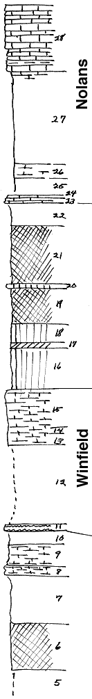
Herington ls member |
|
| 28 |
Limestone, flaggy |
9.5 |
| |
Paddock sh member |
|
| 27 |
Shale, gray |
13.5 |
| |
Krider ls member |
|
| 26 |
Shale, calc, with Septopora, Rhombopora, Dictyoclostus and Derbya |
2 |
| 25 |
Shale |
2.6 |
| 24 |
Shale, calc, with crinoid-joints abd Aviculopecten |
.4 |
| 23 |
Limestone, oolitic, flaggy |
.7 |
| |
Odell sh member |
|
| 22 |
Shale, gray |
3.3 |
| 21 |
Shale, red |
8.4 |
| 20 |
Shale, green, calc |
.6 |
| 19 |
Shale, red |
5 |
| 18 |
Shale, green |
3 |
| 17 |
Shale, purple |
.8 |
| 16 |
Shale, sandy, green |
5.8 |
| |
Cresswell ls member |
|
| 15 |
Limestone, somewhat flaggy, with echinoid remains |
5.5 |
| 14 |
Limestone, flaggy, with echinoid remains, crinoid joints, and Derbya |
1 |
| 13 |
limestone with echinoid remains and Composita |
1.5 |
| |
Grant sh member |
|
| 12 |
Covered |
11.5 |
| |
Stoval ls member |
|
| 11 |
Limstone, largely replaced by flint |
1 |
| |
Gage sh formation |
|
| 10 |
Shale |
2 |
| 9 |
Shale, calc, with Derbya, few Myalina, and crinoid joints |
3 |
| 8 |
Mudstone, soft, full of Derbya; also few Dictyoclostus |
1.5 |
| 7 |
Shale, gray |
7 |
| 6 |
Shale, red |
6.5 |
| 5 |
Covered |
30 |
| |
Towanda ls formation |
|
| 4 |
Limestone, somewhat flaggy, with small pelecypods and gastropods |
2 |
| 3 |
Limestone, splittery |
1 |
| 2 |
Limestone |
1 |
| 1 |
Limestone, splittery |
1 |
|