 |
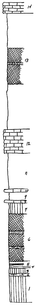
| Unit No. |
Description |
Thickness
ft. |
| 14 |
Hollenberg ls, exposed northwest of and also a few miles south of city, gray, fossiliferous, forms large brnish, flat blocks |
3-4 |
| 13 |
Sh, the main pt of the Pearl member, top zone gray with many small, calc bodies; middle zone largely red, with thin bands of gray and olive, basal part grayish |
38-40 |
| 12 |
Herington ls, typically exposed at many places |
8 |
| 11 |
Paddock sh, gray, typical |
~12 |
| |
Krider ls |
|
| 10 |
Ls, gray, fossiliferous, weaths buff |
1 |
| 9 |
Sh, gray, loosley indurated |
2.66 |
| 8 |
Ls, gray, quite fossiliferous, earthy at base |
1.33 |
| |
Odell sh |
|
| 7 |
Sh, gray and olive, blocky and indurated near base |
3.5 |
| 6 |
Sh, largely red, with bands of olive sh and a subzone of mudstone, 6' abve base |
16 |
| |
Sh and mudstone, largely gray |
|
| 5 |
Sh, gray, with dk bands |
2 |
| 4 |
Mudstone |
.42-.5 |
| 3 |
Sh, olive, argillaceous |
2 |
| 2 |
Sh, loosley indurtated, bedded, calc |
.58 |
| 1 |
Sh, in grnish, olive & dk grn bands, pt calc and geodal |
4.5 |
|