 |
| Unit No. |
Description |
Thickness
ft. |
| |
Dakota ss |
|
| |
Unconformity |
|
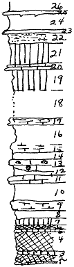
| 26 |
Shale, yellow |
1.5 |
| 25 |
Shale, sandy, yellow, with salt and ripple marks |
.2 |
| 24 |
Shale, yellowish-gray |
2.5 |
| 23 |
Mudstone, splitttery |
.3 |
| 22 |
Shale, sandy, green, banded |
1.7 |
| 21 |
Shale, bluish-green |
3 |
| 20 |
Mudstone, yellowish-green, flaggy |
1 |
| 19 |
Shale, greenish-yellow |
3 |
| 18 |
Covered |
4 |
| 17 |
Mudstone, yellow, splittery |
1 |
| 16 |
Shale, gray |
3 |
| 15 |
Shale, yellow |
1 |
| 14 |
Shale, gray |
1 |
| 13 |
Mudstone, yelow-gray, with geodes and microfauna |
1-2 |
| 12 |
Shale, gray |
1 |
| 11 |
Mudstone, yelow-gray, with numerous veins of calcite |
1 |
| 10 |
Shale, gray |
2.5 |
| 9 |
Shale, sandy, bluish-gray, splittery |
1.5 |
| 8 |
Shale, snady, greenish-gray |
1 |
| 7 |
Shale, greenish-gray |
1 |
| 6 |
Shale, maroon |
.7 |
| 5 |
Shale, greenish-gray |
.3 |
| 4 |
Shale, maroon |
2.6 |
| 3 |
Shale, greenish-gray |
.1 |
| 2 |
Shale, maroon |
1.2 |
| 1 |
Shale, greensh-gray |
.1 |
|