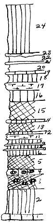
 |
| Unit No. |
Description |
Thickness
ft. |
| |
Perl sh formation |
|
| 24 |
Shale, green |
10 |
| 23 |
Mudstone, yellow-brown, with calcite veins |
.5 |
| 22 |
Shale |
1.5 |
| 21 |
Mudstone, yellow, with calcite veins |
.5 |
| 20 |
Shale |
2 |
| 19 |
Mudstone |
.1 |
| 18 |
Shale, light green |
2.5 |
| 17 |
Mudstone, splittery |
1 |
| 16 |
Shale, light green |
2.5 |
| 15 |
Shale, purple with few green spots |
4 |
| 14 |
Shale, green |
.4 |
| 13 |
Shale, purple |
2 |
| 12 |
Shale, green |
.3 |
| 11 |
Mudstone, splittery, yellow-green |
1 |
| 10 |
Shale |
1 |
| 9 |
Mudstone, green |
.1 |
| 8 |
Shale, green |
.9 |
| 7 |
Mudstone, green to brown, with calcite veins |
.2 |
| 6 |
Shale, green, banded at top |
1 |
| 5 |
Shale, maroon |
3 |
| 4 |
Shale, light green, with maroon spots |
1.5 |
| 3 |
Shale, maroon, with few green spots |
3 |
| 2 |
Shale, light green |
5 |
| 1 |
Top of Herington ls |
1 |
|