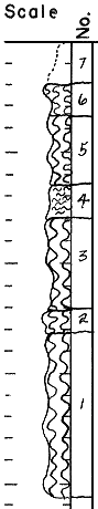
KGS Home

Geology Index Page

Washington County

Sec 30, T. 2 S, R. 2 E.
Move to another county

Measured by Plummer and Romary, 2/26/1940
location within section
strat column from original form
Unit No. Description Thickness
ft.
7 Residual 1.8
6 Clay--slightly silty, light gray with brown mottling 1.4
5 Clay--dark gray and slightly red mottled 3.4
4 Silt--clayey; buff and dark yellow, limonite specks 1.5
3 Clay--slightly silty, light gray and some red mottling, lower 0.16 has considerable yellow; some gypsum 4.1
2 Clay--silty, yellow and red mottled, limonite specks 1.0
1 Clay--slightly silty, light gray and red mottled. Limonite and hematite specks, some yellow joint stain in upper one half.  
3 3/4 miles W. of Morrowville
Measured by Plummer and Romary, 2/26/1940
Remarks: Composite of three pits
location within section
strat column from original form
Unit No. Description Thickness
ft.
7 SANDSTONE--brown too yellow ±9.0
6 SANDSTONE--brown to yellow 2.0
5 CLAY--plastic, gray with very little yellow stain, lignite particles 7.9-9.0
4 CLAY--plastic, gray with some yellow stain, lignitic particles, silty streak 0.8' from bottom 4.1-5.2
3 CLAY--plastic, gray with slight yellow stain in joints ±3.5
2 CLAY--silty, light gray and red mottled, yellow streak 1.5' from bottom, some yellow throughout, slight gypsum ±6.4
1 SILT--gray and yellow 1.0


Kansas Geological Survey
Updated Nov. 2000
Comments to webadmin@kgs.ukans.edu
URL=http://www.kgs.ukans.edu/General/Geology/Measured/tw/Washington/2_2E_30.html