 |
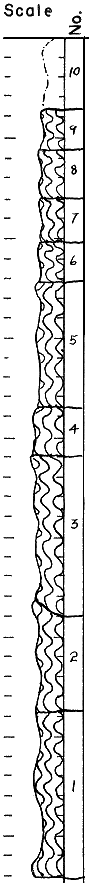
| Unit No. |
Description |
Thickness
ft. |
| 10 |
Soil--Pleistocene (?), gray, humic |
3.5 |
| 9 |
Clay--plastic, red and some gray and cream, may be fill or residual, gyp present |
2.0 |
| 8 |
Clay--plastic, red and some gray, gypsum, bottom oblique, dip NE |
2.7 |
| 7 |
Clay--plastic, brown and gray |
2.0 |
| 6 |
Clay--slightly silty, gray with some yellow and red stain |
2.0 |
| 5 |
Clay--fairly plastic, gray to dark gray and slightly red mottled, slight yellow in joints, conchoidal fracture |
8.8 |
| 4 |
Clay--slightly silty, light gray and dark red mottled, red in vertical masses, pronounced dendritic pattern in red and lavender, some lavender and slight yellow |
8.0 |
| 3 |
Clay--fairly plastic, very light gray and dark red mottled, red weathered granular hematite |
4.5 |
| 2 |
Clay--plastic, gray and red mottled, cosiderable lavender, some dendritic pattern, yellow on slickenside joints |
5.5 |
| 1 |
Clay--fairly plastic, light gray and red ottled lavender stain, very slight yellow, slightly silty in parts, dendritic pattern |
8.3 |
|