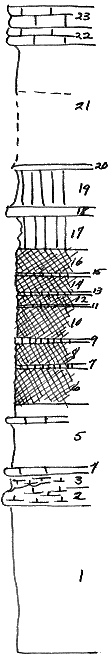
 |
| Unit No. |
Description |
Thickness
ft. |
| |
Herrington ls member |
|
| 23 |
Mudstone, massive, lt-gray |
2 |
| 22 |
Mudstone, massive, with Pirina, Allorisma, and other pelecypods and Bellerophon |
2 |
| |
Paddock sh member |
|
| 21 |
Sh, lt yellowish-gray. Krider ls member |
12.2 |
| 20 |
Mudstone, lt-gray |
.3 |
| 19 |
Sh, grnish-gray |
4 |
| 18 |
Mudstone, lt-gray, with Pseudomonotis, Aviculopecten, and Hyalina near the top. Odell sh formation |
.8 |
| 17 |
Sh, grnish-gray |
3.5 |
| 16 |
Sh, red |
2.5 |
| 15 |
Sh, grnish-gray |
.1 |
| 14 |
Sh, red |
1.7 |
| 13 |
Sh, grnish-gray |
.1 |
| 12 |
Sh, red |
.8 |
| 11 |
Sh, grnish-gray |
.3 |
| 10 |
Sh, red |
3.2 |
| 9 |
Sh, grnish-gray |
.3 |
| 8 |
Sh, red |
2 |
| 7 |
Sh, grnish-gray |
.5 |
| 6 |
Sh, red |
4 |
| 5 |
Sh, grnish-gray, with thin bed of Mudstone near the top. Cresswell (?) ls member |
6 |
| 4 |
Mudstone |
.5 |
| 3 |
Sh, calc |
2.5-1 |
| 2 |
Mudstone. Grant sh member |
1-2.5 |
| 1 |
Sh, gray to dk-gray (interbedded) |
15 |
|