 |
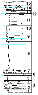
| Unit No. |
Description |
Thickness
ft. |
| |
Schroyer limestone member |
|
| 15 |
Flint |
1.5 |
| 14 |
Limestone with two bands of flint |
1.5 |
| |
Havensville shale member |
|
| 13 |
Shale |
1 |
| 12 |
Mudstone |
0.5 |
| 11 |
Shale, green |
3.5 |
| 10 |
Mudstone, with Pinna and Allorisma |
1.5 |
| 9 |
Mudstone, splitteryl Derbya, Pinna, and small
Composita at the top |
3.5 |
| 8 |
Shale, calcareous at the top |
9 |
| |
Threemile limestone member |
|
| 7 |
Limestone with flint band |
1.2 |
| 6 |
Limestone |
0.8 |
| 5 |
Covered |
1.5 |
| 4 |
Limestone with flint band in upper part; Composita |
1.1 |
| 3 |
Shale, calcareous |
0.3 |
| 2 |
Limestone with flint band, Composita |
0.8 |
| |
Speiser shale formation |
|
| 1 |
Shale, gray |
1 |
|