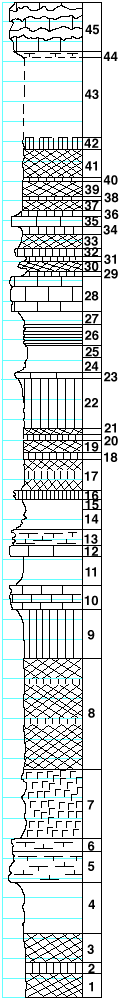
 |
| Unit No. |
Description |
Thickness
ft. |
| |
Threemile limestone member |
|
| 45 |
Limestone with three broad bands of flint. Fenestella
and other bryozoa, Phillipsia |
5 |
| 44 |
Shale, calcareous, with crinoid joints |
0.5 |
| |
Speiser shale formation |
|
| 43 |
Covered |
8 |
| 42 |
Shale, green |
1 |
| 41 |
Shale, purple |
3 |
| 40 |
Shale, green |
0.2 |
| 39 |
Shale, purple |
1.5 |
| 38 |
Shale, green |
0.2 |
| 37 |
Shale, red |
1 |
| 36 |
Shale, green |
0.5 |
| 35 |
Limestone, light-gray, crystalline |
1 |
| 34 |
Shale, green |
0.8 |
| 33 |
Shale, dark-purple |
1.2 |
| 32 |
Mudstone, light-green, bedded |
0.8 |
| 31 |
Shale, green |
0.5 |
| 30 |
Shale, purple |
1 |
| 29 |
Shale, green |
0.5 |
| |
Funston limestone member |
|
| 28 |
Limestone, massive, breaks into large blocks, shows
some stratification, contains poor and small fossils,
among which are small plump gastropods (Funston limestone) |
3.5 |
| |
Blue Rapids shale member |
|
| 27 |
Shale, gray |
1.5 |
| 26 |
Shale, almost black, splittery |
2 |
| 25 |
Shale, gray |
1 |
| 24 |
Shale, very fossiliferous |
1.5 |
| 23 |
Limestone, light-gray, fossiliferous |
0.8 |
| 22 |
Shale, light-green |
5 |
| 21 |
Shale, maroon |
0.5 |
| 20 |
Shale, green |
0.5 |
| 19 |
Shale, maroon |
1.3 |
| 18 |
Shale, light-greenish-gray |
0.7 |
| 17 |
Shale, bands of dark-purple and dark green |
3 |
| 16 |
Mudstone, cavernous, green, with some blue-green
glauconite in caverns |
1 |
| 15 |
Shale, gray |
1 |
| 14 |
Shale, gray, platy |
2 |
| |
Crouse limestone member |
|
| 13 |
Mudstone, green, platy with vertical veinlets of
crystalline calcite |
1.5 |
| 12 |
Limestone, granular, fossiliferous, with thin
veinlets of calcite |
1 |
| 11 |
Shale, gray, fossiliferous at the base |
3 |
| 10 |
Limestone, fossiliferous, common Pseudomonotis
near the base |
2.5 |
| |
Easly Creek shale formation |
|
| 9 |
Shale, green |
5 |
| 8 |
Shale, red, with a few thin green bands |
11 |
| 7 |
Gypsum leached out at the exposure, in the mine |
7-8 |
| |
Middleburg limestone member |
|
| 6 |
Limestone with Pseudomonotis, Aviculopecten, Septopora,
Allorisma, Juresania nebrascensis |
1.3 |
| 5 |
Limestone, impure and platy near the top; same fauna
as listed above in the upper half; Pseudomonotis and other
pelecypods in the lower half |
3 |
| 4 |
Shale, gray, solid |
5 |
| 3 |
Shale, red |
3 |
| 2 |
Shale, green |
1 |
| 1 |
Shale, red |
2.5 |
|