 |
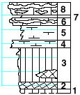
| Unit No. |
Description |
Thickness
ft. |
| |
Threemile limestone (8-6) |
|
| 8 |
Limestone, massive, with one flint band in upper part
and two in lower part, crinoid joints, Enteletes (?), Rhipidonella
carbonaria, Pinna |
2 |
| 7 |
Shale |
0.2 |
| 6 |
Limestone with one flint bed |
1 |
| 5 |
Shale, gray, fossiliferous; Chonetes, Derbya, Composita,
Juresania, crinoid joints |
2.2 |
| 4 |
Mudstone with Allorisma, Pinna, Pseudomonotis, and Aviculopecten |
0.8 |
| 3 |
Shale, green, calcareous near top, maroon band near base |
5 |
| 2 |
Shale, maroon |
0.8 |
| 1 |
Shale, green |
0.5 |
|