 |
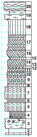
| Unit No. |
Description |
Thickness
ft. |
| |
Florence limestone member |
|
| 20 |
Limestone, solid, with flint bands |
3 |
| |
Blue Springs shale formation |
|
| 19 |
Shale, calcareous |
1 |
| |
Limestone |
2 |
| 18 |
Shale, green |
5 |
| 17 |
Shale, red and purple with few green bands |
5 |
| 16 |
Shale, red, somewhat hardened |
2.2 |
| 15 |
Shale, green |
0.7 |
| 14 |
Shale, red, somewhat hardened |
2 |
| 13 |
Shale, green |
0.5 |
| 12 |
Shale, purple |
0.5 |
| 11 |
Shale, red |
1 |
| 10 |
Shale, purple, with dark-green band on top |
1.5 |
| 9 |
Shale, purple, with green bands |
2.5 |
| 8 |
Shale, green |
1 |
| 7 |
Shale, light-gray, finely bedded, somewhat hardened |
4 |
| 6 |
Shale, black, massive |
1 |
| 5 |
Shale, light-gray, finely bedded, somewhat hardened,
with Lingula |
3 |
| 4 |
Shale, dark-gray to black, massive, in lower part
gypsum nodules |
2.5 |
| |
Kinney limestone formation |
|
| 3 |
Limestone, platy, shaly, blue-gray, in upper part with gypsum
nodules and Pinna, Allorisma, and Derbya |
3 |
| 2 |
Shale |
1.5 |
| 1 |
Limestone |
0.5 |
|