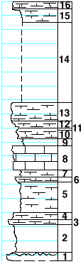
 |
| Unit No. |
Description |
Thickness
ft. |
| |
Holmesville shale formation |
|
| 16 |
Limestone, crystalline, yellowish-gray, cavernous |
1 |
| 15 |
Mudstone, soft |
2 |
| 14 |
Covered |
11.5 |
| 13 |
Limestone, very calcareous and fossiliferous (Meekella
and other fossils) |
2.5 |
| 12 |
Mudstone, cavernous |
1 |
| 11 |
Shale |
0.2 |
| 10 |
Limestone |
1.5 |
| 9 |
Shale |
1 |
| |
Fort Riley limestone member |
|
| 8 |
Limestone |
3.5 |
| 7 |
Shale |
1 |
| 6 |
Limestone, very fossiliferous (Straparollus and other fossils) |
0.5 |
| |
Oketo shale member |
|
| 5 |
Shale |
4.2 |
| 4 |
Limestone, splittery |
1 |
| 3 |
Limestone, solid |
0.8 |
| 2 |
Shale, blue-gray |
4 |
| |
Florence limestone member |
|
| 1 |
Limestone with bands of flint |
-- |
|