 |
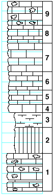
| Unit No. |
Description |
Thickness
ft. |
| |
Schroyer limestone |
|
| 9 |
Limestone, poorly exposed, cherty |
5 |
| 8 |
Limestone, badly weathered, irregular |
3.5 |
| 7 |
Limestone, dark gray, massive, uneven at top and bottom,
grading into shaly lime |
5-6 |
| 6 |
Limestone, shaly, slabby |
3.5 |
| 5 |
Limestone, weathers slabby to shaly with Aviculopecten, etc. |
3 |
| 4 |
Limestone, massive, irregular |
1.66 |
| |
Havensville shale |
|
| 3 |
Shale, slabby |
3 |
| 2 |
Shale, largely olive and gray and with some fossils |
5 |
| 1 |
Four Mile limestone, cherty, massive, with thin shale partings |
7.5-8 |
|