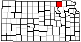
 |
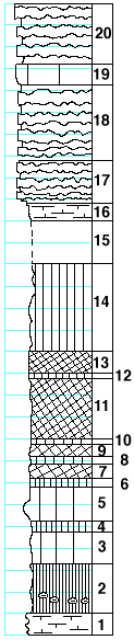
| Unit No. |
Description |
Thickness
ft. |
| |
Florence limestone member |
|
| 20 |
Limestone with flint bands |
5.5 |
| |
Blue Springs shale formation |
|
| 19 |
Limestone, massive, white |
2 |
| 18 |
Limestone with flint bands |
7 |
| 17 |
Limestone with six flint bands, the lower three close together |
4 |
| 16 |
Shale, calcareous, finely laminated, gray, with Dictyoclostus
americanus and other fossils |
1.5 |
| 15 |
Covered |
4 |
| 14 |
Shale, green |
8 |
| 13 |
Shale, red |
2 |
| 12 |
Shale, green |
0.5 |
| 11 |
Shale, red |
5.5 |
| 10 |
Shale, green |
0.5 |
| 9 |
Shale, purple |
1 |
| 8 |
Shale, green |
0.5 |
| 7 |
Shale, purple |
1 |
| 6 |
Shale, dark-green |
0.8 |
| 5 |
Mudstone, soft, light-green |
3.2 |
| 4 |
Shale, dark-green |
1 |
| 3 |
Shale, light-green, massive |
3 |
| 2 |
Shale, dark-gray to black, massive, with Anthracomya |
4.5 |
| |
Kinney limestone formation |
|
| 1 |
Limestone, soft, splittery, dark-gray |
2 |
|