KGS Home

Geology Index Page

Marshall County

Sec 30, T. 2 S, R. 9 E.
Move to another county

On U.S. Highway 36, 2 1/4 miles west of Highway K-11
Measured by M.K. Elias, 1932
Remarks: II-9
location within section
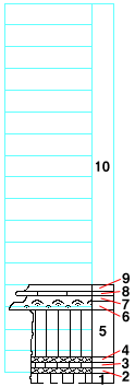
strat column from original form
Unit No. Description Thickness
ft.
10 To the base of three Mile limestone member 26.5 ±
9 Shale, gray 0.6
8 Mudstone 0.4
7 Shale, gray 0.5
6 Limestone made largely of calcareous algal structure 0.6
5 Shale, green 4.5
4 Shale, purple 0.5
3 Shale, green 0.7
2 Shale, purple 0.3
1 Shale, green 1
Note: This section probably is entirely in the upper part of the Blue Rapids shale member.


Kansas Geological Survey
Updated Nov. 2000
Comments to webadmin@kgs.ku.edu
URL=http://www.kgs.ku.edu/General/Geology/Measured/klm/Marshall/2_9E_30.html