 |
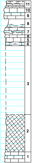
| Unit No. |
Description |
Thickness
ft. |
| |
Sterns shale formation |
|
| 11 |
Mudstone, white, slabby, with pelecypods, Orbiculoidea and
Lingula |
2.5 |
| |
Beattie limestone formation |
|
| 10 |
liemstone, gray, with Allorisa and Derbya |
1.3 |
| 9 |
Limestone, gray, with Composita, Derbya, and crinoid joints |
2 |
| |
Florence shale member |
|
| 8 |
Shale, calcareous, wspecially near the base, with Composita,
Chonetes, Dictyoclostus, Pinna, and bryozoa |
2.8 |
| |
Cottonwood limestone member |
|
| 7 |
Limestone, massive, full of fusulinids, with flint nodules
in lower part |
2.5 |
| 6 |
Limestone, massive |
1 |
| 5 |
Limestone, slabby |
1.5 |
| 4 |
Mudstone, splittery |
1 |
| |
Eskridge shale formation |
|
| 3 |
Covered |
22 |
| 2 |
Shale, cheifly maroon |
12 |
| |
Neva limestone formation |
|
| 1 |
Limestone, slabby |
3.5 |
|