 |
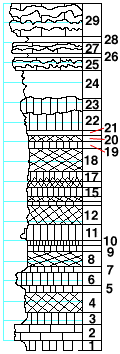
| Unit No. |
Description |
Thickness
ft. |
| |
Three Mile limestone member |
|
| 29 |
Limestone, upper part made almost entirely of flint,
in lower part two flint bands |
3.5 |
| 28 |
Shale, calcareous |
0.5 |
| 27 |
Limestone, with flint band in upper part |
1 |
| 26 |
Shale, calcareous |
0.4 |
| 25 |
Limestone, with flint band in upper part |
1 |
| |
Speiser shale formation |
|
| 24 |
Shale, gray, calcareous. Near the top Composita, Derbya,
Chonetes, Orbiculoidea. Near the base Derbya, Myalina,
Aviculopecten |
3 |
| 23 |
Limestone, light-green, full of small fragments of fossils |
1 |
| 22 |
Shale, greenish-gray to yellowish |
2 |
| 21 |
Shale, dark-green |
0.5 |
| 20 |
Shale, mottled dark-green and purple |
0.5 |
| 19 |
Shale, green |
0.5 |
| 18 |
Shale, purple |
2.5 |
| 17 |
Shale, green, mottled with purple at the base |
1 |
| 16 |
Shale, purple |
0.5 |
| 15 |
Shale, green |
1 |
| 14 |
Shale, purple |
0.5 |
| 13 |
Shale, green |
0.2 |
| 12 |
Shale, purple |
2 |
| 11 |
Shale, light-green, harder in lower part |
1.5 |
| 10 |
Shale, dark-green |
0.5 |
| 9 |
Shale, light-green |
0.5 |
| 8 |
Shale, red |
1.5 |
| 7 |
Shale, green |
0.5 |
| |
Funston limestone member |
|
| 6 |
Mudstone, light-green, with unidentifiable fossils |
1.5 |
| 5 |
Shale, green |
0.8 |
| 4 |
Shale, maroon |
2 |
| 3 |
Shale, green |
1 |
| 2 |
Limestone, shaly, cavernous, yellowish, full of small
undeterminable fossils near the top |
1.5 |
| 1 |
Shale, green |
1 |
|