 |
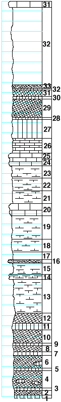
| Unit No. |
Description |
Thickness
ft. |
| |
Krider limestone member |
|
| 35 |
Limestone |
1 |
| |
Odell shale formation |
|
| 34 |
Shale, gray |
15.5 |
| 33 |
Shale, red |
0.6 |
| 32 |
Shale, green |
0.2 |
| 31 |
Shale, red |
1.2 |
| 30 |
Shale, green |
0.3 |
| 29 |
Shale, red |
3.7 |
| 28 |
Shale, green |
0.2 |
| 27 |
Shale, light green |
3.8 |
| 26 |
Mudstone, soft, massive, green-gray, concretions in upper part |
3 |
| 25 |
Limestone, light-gray, cavernous, softer toward base |
1.2 |
| 24 |
Limestone, light-gray, softer toward base, with pelycypods
and gastropods |
1.3 |
| 23 |
Shale, calcareous, with pelycypods and gastropods |
2.5 |
| |
Cresswell ls member and Grant sh member |
|
| 22 |
Shale, calcareous, with crinoid and echinoid remains,
Linoproductus, Allorisma, few Myalina, bryozoa, Derbya,
and Composita |
2.5 |
| 21 |
Shale, calcareous, with Derbya and Composita |
2.5 |
| 20 |
Limestone to mudstone with large Derbya, Allorisma,
and Schizodus |
2.5 |
| 19 |
Shale, calcareous, with Dictyoclostus in middle |
4.5 |
| 18 |
Shale, calcareous, with crinoid and echinoid remains,
Composita, and few Derbya |
2.5 |
| 17 |
Shale, gray |
1.5 |
| |
Stovall ls member |
|
| 16 |
Flint with large Derbya |
0.5 |
| |
Gage sh formation |
|
| 15 |
Shale, calcareous |
2.2 |
| 14 |
Mudstone, with numerous large Derbya and few Dictyoclostus |
0.8 |
| 13 |
Shale, gray, calcareous, with Derbya and
Dictyoclostus americanus |
7 |
| 12 |
Shale, red |
1.7 |
| 11 |
Shale, green |
1.1 |
| 10 |
Shale, red |
2.6 |
| 9 |
Shale, green |
0.5 |
| 8 |
Shale, red |
1.1 |
| 7 |
Shale, green |
0.6 |
| 6 |
Shale, red, unpersistent green band in lower part |
2.5 |
| 5 |
Shale, green |
0.3 |
| 4 |
Shale, red, unpersistent green band in lower part |
3.8 |
| 3 |
Shale, green |
0.3 |
| 2 |
Shale, red |
0.9 |
| 1 |
Shale, green |
0.4 |
| |
(Bottom of eastern trench of the road) |
|
|