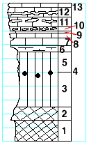
 |
| Unit No. |
Description |
Thickness
ft. |
| |
Cottonwood limestone member |
|
| 13 |
Limestone, full of fusulinids |
0.3± |
| 12 |
Limestone, with two bands of small flint nodules in the
middle. Full of fusulinids. |
1.8 |
| 11 |
Limestone, with two bands of medium large flint nodules
in upper half; fusulinids near top |
1.2 |
| 10 |
Limestone with numerous flint nodules |
0.4 |
| 9 |
Limestone, yellow, ferruginous |
0.2 |
| 8 |
Limestone, with few Composita, Lophophyllum, and crinoid
joints near the base |
0.8 |
| 7 |
Limestone |
1.2 |
| 6 |
Limestone, clayey splittery |
0.9 |
| |
Eskridge shale formation |
|
| 5 |
Shale, green |
3 |
| 4 |
Geodes with quartz and amethyst |
|
| 3 |
Shale, green |
5 |
| 2 |
Mudstone, light-purple and green |
2 |
| 1 |
Shale, purple |
3 |
|