![]()
Prev Page--Introduction || Next Page--Geology
Geography
Relief
Meade County lies partly within the High Plains section and partly within the Plains Border section of the Great Plains physiographic province, the boundary line, as designated by Fenneman (1931), passing across the county from north to south, west of Crooked Creek valley. The topography of the western and north-western parts of the county, which are in the High Plains section, is quite flat and featureless. Low sand dunes occur on the surface along the Seward county line north of the Cimarron valley. The eastern and southeastern parts of the county, which are in the Plains Border section, are relatively rough and locally present steep slopes. Isolated areas of flat upland and areas of upland sand dunes also occur in this part of the county, however. The lowest point in the county occurs where the valley of Crooked Creek crosses the Kansas-Oklahoma state line. The valley floor at this point is at an altitude of about 2,100 feet. The High Plains in the northwestern part of the county rise to an altitude of nearly 2,800 feet and include the highest point in the county. The total relief of the area, therefore, is about 700 feet. The greatest local relief, 250 feet, occurs along the south side of the Cimarron valley in the southwestern corner of the county, and also along Crooked Creek valley in the southeastern part of the county.
The topography is to a certain extent a reflection of the underlying deposits. The flat High Plains are underlain chiefly by the Kingsdown silt, and the steep sided canyons are cut in the relatively resistant beds of the Ogallala formation and in Permian rocks.
Drainage
All of Meade County is drained by the Cimarron River and its tributaries. Most of this area is drained by Crooked Creek, which enters the north-central part of the county, flows eastward along the north side, and in a wide swing leaves and reenters the county in the northeastern corner. From that point it flows south-southwest across the central part of the county, but about 6 miles from the state line it swings sharply to the southeast and joins the Cimarron in Beaver County, Oklahoma, south of the southeastern corner of Meade County. Sand Creek, which with its tributaries drains east central Meade County, joins the Cimarron in southern Clark County.
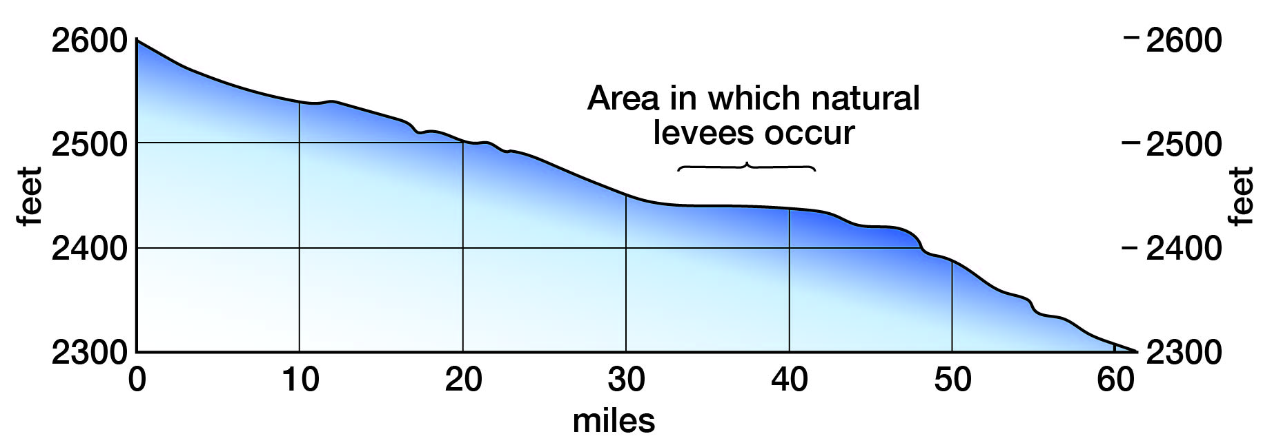
The gradient of the Cimarron River, for the distance it flows across this area, is approximately 10 feet to the mile. For reasons given under Geologic history, the gradient of Crooked Creek differs in three segments of its course through the county as follows: upstream from Fowler it is 5 feet to the mile, from Fowler to Meade it is 3 feet to the mile, and downstream from Meade it is 8 feet to the mile. The gradient of Crooked Creek across northern and central Meade County is shown in figure 2.
Figure 2--Gradient of Crooked Creek across northern and central Meade County. Altitudes based on topographic map of the Meade quadrangle.
Climate
This county lies in a region only moderately well supplied with rainfall, but well supplied with sunshine. About 75 percent of the annual precipitation falls in the six-month period from April through September, when the moisture is most needed. The average precipitation for this six-month period in this part of Kansas is approximately the same as that in the Dakotas and three-fourths of the average for Illinois, Indiana and Ohio. The normal annual precipitation at Plains, the one Weather Bureau station maintained in the county, is 20.86 inches, but the average annual precipitation for the 31-year period of record is 18.43 inches. The wettest year of record, as shown in figure 3, was 1915, when 31.62 inches fell at Plains. The driest year of record was 1910, when only 9.35 inches fell. January is the driest month and June the wettest month of the year.
The average annual snowfall is about 17 inches. As a rule the ground is not covered with snow for more than a few days at a time, even in midwinter, on account of the melting effects of sunshine and drying winds.
The annual precipitation at Plains since the beginning of the period of record, cumulative departure from normal precipitation, and cumulative departure from average precipitation, are shown in figure 3.
Figure 3--Precipitation at Plains, Meade County. A, Annual departure from normal precipitation at Plains; B, Cumulative departure from normal precipitation at Plains; C, Cumulative departure from the average precipitation during the 31 year of record at Plains. A larger version of this figure is available.
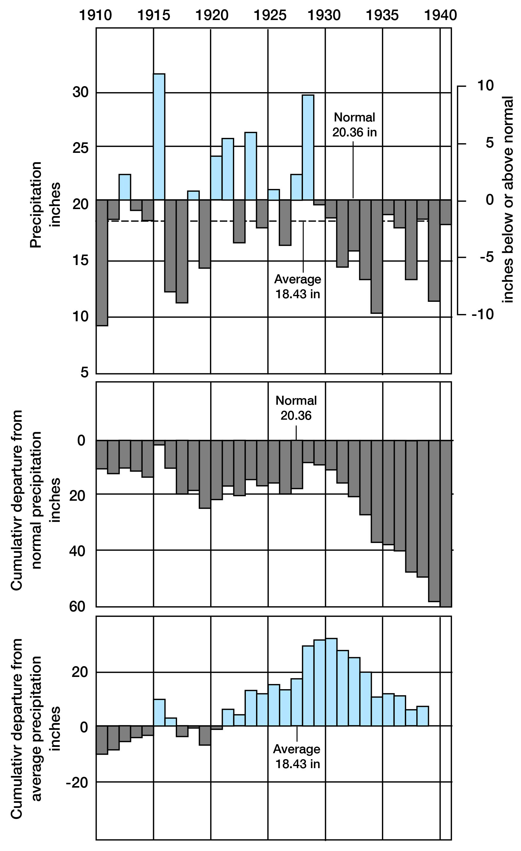
It is to be noted that the graphs showing the cumulative departures from normal and average precipitation show a roughly rhythmic, or cyclic, repetition of periods of excess and deficient precipitation. Although graphs B and C in general are similar in shape, graph B shows an extreme cumulative departure below normal at the end of 1940, whereas graph C shows that there is no cumulative departure from the average precipitation by the end of 1940. This apparent discrepancy results from the fact that the normal selected by the Weather Bureau is 1.93 inches more than the actual average annual precipitation during the period of record.
This area is subject to heated periods during the summer and severe drops in temperature during the winter. The average annual temperature is about 56° F. Temperature data are not available for any station in Meade County; hence, the extremes of temperature cannot be given.
Population
According to the 1940 census the population of Meade County was 5,522; an average of about 5.7 inhabitants to the square mile, as against 21.9 for the entire state. Meade, the county seat and largest city in the county, had a population of 1,400 in 1940. Two other cities in the county, Plains (or West Plains) and Fowler, had populations in 1940 of 619 and 563, respectively.
Transportation
The county is crossed by the main line of the Chicago, Rock Island and Pacific Railroad from Chicago to Tucumcari, New Mexico, which traverses, the northern part of the county through Fowler, Meade and Plains. The area is covered by a network of modern highways and improved secondary roads. The most heavily traveled highways are U. S. Route 54 through Fowler, Meade and Plains; U. S. Route 160 through Meade and Plains; and Kansas Route 23, which crosses the county from north to south through Meade. The remainder of the county is served by numerous improved county and township roads (pl. 1).
Agriculture
On the basis of agriculture and land utilization Meade County can be divided roughly into three rather distinct areas, or groups of areas, namely: (1) the High Plains area, in the western and northwestern parts of the county, and also some flat upland areas southeast of Meade; (2) broken and dissected areas along the valleys of Cimarron River, Sand Creek and Crooked Creek, and parts of the areas of sand dunes that are too rugged or too thinly mantled by soil to plow; and (3) the artesian-basin area, and adjacent parts of Crooked Creek valley. In any discussion of the agriculture of the county these three divisions must be considered separately because of the considerable variation in conditions existing in each.
In the High Plains part of the county there occurs a nearly unbroken flat surface, which prior to cultivation was covered with a continuous blanket of short grass. The water table lies deep beneath this part of the county, in most places more than 100 feet below the surface.
In the broken and dissected areas and in the rugged areas of sand dunes the land is not suitable to cultivation, the native vegetation is quite diverse, and the depth to water level ranges from a few feet to more than 100 feet below the surface. The surface of the artesian basin area is mainly gently rolling to flat, and, although part of this area was originally covered by short grass, some of it supported (and still does) a more luxuriant growth suitable for cutting as prairie hay. Shallow ground water occurs under most of this area and deeper drilling produces flowing artesian wells or artesian wells in which the water rises to within a few feet of the surface.
Prior to the 1880's the entire region had been devoted to stock raising, but during the later part of the nineteenth century there occurred a rapid immigration of farmers. Johnson (1901, p. 681) describes this immigration into the High Plains as follows:
The movement of settlers into the High Plains was an inroad. The only population there at the time consisted of a few stockmen making common use of the public range. The newcomers were farmers and town builders. The farmer's aim heretofore had been agriculture by irrigation along the stream bottoms; the interstream areas were in any case left in his (stockman's) possession undisturbed. But, in this case irrigation was not in contemplation; the interstream areas, not the valleys, were invaded, and in some, parts of the High Plains, notably western Kansas, the stockmen were completely dispossessed.
This rapid settlement of the High Plains region by farmers probably was precipitated by several wet years and the resulting good crops at the beginning of this period. Before the turn of the century, however, the wet weather gave way to a succession of dry years, and by 1900 the immigration had not only ceased, but there was an exodus of settlers to other regions.
The collapse of this early experiment in wheat farming on the High Plains was almost complete. Johnson (1901, p. 690) in 1900, painted a vivid word picture of the visible evidence of this failure:
An idea of the magnitude of the scale on which the attempt to farm the High Plains was made, especially in Western Kansas, as well as the great aggregate losses that must have resulted from this attempt, is strikingly to be had from the frequent spectacle of abandoned towns systematically spaced upon the flat uplands in anticipation of a dense but uniform farming population, for which they were to have been points of supply. The rectangular subdivision system of the Land Office is indicated almost universally by plowed roadways, blocking out square mile sections, within which the old plowed fields, amounting in the total to millions of acres, are slowly returning to grass, while occasional leaning fence posts, with dangling strands of barbed wire, mark the former lines of many thousand miles of fencing.
Johnson's discussion applies to the High Plains and probably can be considered a good description for the High Plains part of Meade County, particularly as his field headquarters were at the city of Meade.
From 1900 to 1917 little wheat farming was attempted on the High Plains. The shallow ground water in the artesian basin, however, was particularly suitable to alfalfa, and the acreage of that crop increased. Because of the development of the tractor and other modern farming equipment, together with the unusually high prices that were paid for farm products during the first World War, many acres in the High Plains and artesian basin again were planted to wheat during the period from 1917 to 1920, and almost no grazing land was left except in the areas of broken topography and rugged sand dunes. The results might have been a repetition of the earlier farming experiment had it not been for the above normal precipitation and improved methods of dry farming that produced several large crops in the decade between 1920 and 1930.
Beginning in 1930 there followed another severe drought, and crop acreage was again reduced. In an attempt to compensate for this deficiency in rainfall several farmers constructed irrigation wells; also, water from existing flowing wells in the artesian basin was used to irrigate small acreages of crops. This latter procedure is one that could be used to a much greater extent in some parts of the artesian basin without great expense, merely by utilizing water for irrigation that now flows to waste.
At the time of writing (1941) the precipitation has again gone above normal, and this, coupled with generally rising prices, may produce a repetition of conditions that existed from 1917 to 1920.
Of the total land area of the county in 1939, 89.9 percent, or 561,675 acres, was classified as farmland, as against 91.7 percent for the entire state. The average size of the 750 farms was 748.9 acres. The principal crops or usage of farmed land in 1939 in percentage of the total farmed acreage were as follows:Table 1--Crops or usage of land in Meade County in 1939, in percentage of total farmed acreage.
| Miscellaneous crops, fallow land, and unplowable pasture | 52 |
| Wheat | 25 |
| Plowable pasture | 19 |
| Sorghum | 3 |
| Hay | 1 |
Natural Resources and Industries
The production and treatment of volcanic ash constitutes one of the most important natural resources and industries of the county. In 1940 ash was being produced from several large pits both north and south of Meade, and in the past ash has been produced from many smaller pits in different parts of the county. The volcanic ash occurs in the Meade formation of Pleistocene age.
Sand and gravel are produced from the Ogallala formation along Crooked Creek, south of Meade; from the Meade formation at several localities west of the city of Meade; and from terrace deposits along the Cimarron valley.
A rich and fertile soil covers much of the county and makes possible widespread agriculture, and in those areas which have not been cultivated it supports various types of pasture grasses and native hay.
Another important natural resource of the area, with which the remainder of this report is concerned, is ground water.
Prev Page--Introduction || Next Page--Geology
Kansas Geological Survey, Geologic History of Kansas
Comments to webadmin@kgs.ku.edu
Web version February 2004. Original publication date Dec. 1942.
URL=http://www.kgs.ku.edu/General/Geology/Meade/04_geog.html