![]()
Prev Page--Geography || Next Page--Ground Water
General Geology
Summary of Stratigraphy
Rocks that crop out in Grant, Haskell, and Stevens Counties are of sedimentary origin and their areal extent is shown on the geologic map (Pl. 1.) The rocks that supply water to wells are the Rexroad formation of Tertiary age, the Meade formation of Pleistocene age, and the Recent alluvium of the Cimarron River and its tributaries. The character and ground-water supply of the geologic formations in this area are described briefly in the generalized section (Table 4) and in more detail in the section on geologic formations and their water-bearing properties.
Table 4--Generalized section of the geologic formations in Grant, Haskell, and Stevens Counties, Kansas.
| System | Series | Subdivision | Thickness (feet) | Physical character | Water supply |
|---|---|---|---|---|---|
| Quaternary | Recent | Alluvium | 0-75 (?) | Coarse sand and gravel containing silt and clay | Yields adequate supplies of relatively hard water to domestic and stock wells |
| unconformable on older formations | |||||
| Dune sand | 0-60 +/- | Medium-grained sand containing fine-grained sand and silt | Does not yield water to wells in this area, but assists in recharge of underlying formations | ||
| unconformable on older formations | |||||
| Recent and Pleistocene | Terrace deposits | 0-10 (?) | Coarse sand and gravel | Do not yield water to wells in this area | |
| unconformable on older formations | |||||
| Kingsdown silt | 0-40 +/- | Silt and fine sand containing nodules of caliche | |||
| disconformity | |||||
| Pleistocene | Meade formation | 50-150 (?) | Sand and gravel at base; sand, silt, clay, and caliche in upper part. Locally contains volcanic ash | Yield abundant supplies of moderately hard water to domestic, stock, irrigation, and public-supply wells | |
| unconformable on older formations | |||||
| Tertiary | Pliocene | Rexroad (?) formation* | 100-200 (?) | Sand and gravel at base; sand, silt, clay, and caliche in upper part. Sand and gravel in part cemented with calcium carbonate | |
| unconformable on older formations | |||||
| Laverne formation | 0-300 (?) | Sand and gravel in lower part; micaceous sand, calcareous sandstone, silt, clay, caliche, and limestone in upper part | Yields water to very few wells in this area because of its relatively great depth below land surface. An important potential source of ground water | ||
| unconformable on older formations | |||||
| Cretaceous | Gulfian** | Graneros shale | 0-30 +/- | Dark-gray to black fissile shale | Yields little or no water to wells in this area |
| Dakota formation | 0-150 | Brown, yellowish-brown, reddish-brown, buff, and tan fine-grained sandstone and varicolored clay | Locally is a potential source of ground water, but is practically unexploited in this area because of its great depth | ||
| Comanchean | Kiowa shale | 0-135 | Dark gray to black shale. Locally contains lenses of sandstone | Yields little or no water to wells in this area | |
| local disconformity | |||||
| Cheyenne sandstone | 0-100 +/- | Gray and white fine-grained to coarse-grained sandstone | Locally is a potential source of ground water, but is practically unexploited in this area because of its great depth | ||
| disconformity | |||||
| Permian | Leonardian and Guadalupian** | Undifferentiated redbeds | 1,500 +/- | Brick-red sandstone and siltstone containing salt, gypsum, anhydrite, and dolomite | Locally is a potential source of ground water, but is practically unexploited in this area because of its great depth and its generally high mineral content |
* Note by R.C. Moore--The deposits designated as Rexroad (?) formation in this publication were called Rexroad formation [without query] in McLaughlin's manuscript of the report, and with acquiescence of supervisory officials of the Federal and State Geological Surveys this manuscript usage was set in print prior to my return from military service. Inasmuch as employment of Rexroad formation in the area here treated involves both a change in stratigraphic classification previously adopted by the Kansas Geological Survey (Frye and Hibbard, 1941; Frye, 1942; Moore, Frye, and Jewett, 1944, Kansas Geol. Survey, Bull. 62, p. 149) and extension in recognition of these deposits beyond Meade County, Kansas, it was desirable to review published and unpublished available data bearing on these changes. All pertinent publications were examined and an unpublished manuscript by Byrne and McLaughlin on Seward County was read. Conferences were held with Dr. J.C. Frye, who has studied Cenozoic deposits in southwestern Kansas extensively, with Dr. C.W. Hibbard, who has collected and studied vertebrate remains from virtually all known southwestern Kansas fossil-bearing localities, and with Dr. A.B. Leonard, who for some years has been investigating fossil molluscan faunas from Cenozoic deposits in western Kansas.
Classification of the Rexroad deposits as a member of the Ogallala formation previously has been judged appropriate on the grounds that (1) known occurrence of these fossil-bearing beds is geographically restricted to parts of Meade County, Kansas, (2) the lower boundary of the Rexroad deposits is poorly defined, (3) lithologic distinction between Rexroad and pre-Rexroad Ogallala deposits is slight or lacking, and (4) there is great difficulty generally in mapping Rexroad as a separate stratigraphic unit. Although a disconformity indicating break in sedimentation is inferred to exist in parts of Meade County at the base of the Rexroad, elsewhere in this region sedimentation of Rexroad on Ogallala was presumed to be conformable (Frye and Hibbard, 1941). Definition of the stratigraphic span of the Ogallala formation in southwestern Kansas properly is not based solely or even primarily on time concepts, in such fashion that it is presumed to exclude deposits interpreted to be younger than the so-called "Algal limestone" of northern Kansas--despite the fact that this limestone marks the top of the Ogallala in the north. Thus, it has seemed proper to apply the name Ogallala in a broadly inclusive manner to Tertiary terrestrial deposits of the western Kansas region in which neither lithologic nor structural grounds for significant subdivision in mapping is afforded. Inasmuch as the Rexroad (?) deposits of Seward County and areas farther west, which are reported to rest unconformably on Laverne deposits, are not established as true Rexroad, evidence is not yet available to show that an important break in sedimentation occurs at the base of the Rexroad; also, satisfactory grounds for recognizing Rexroad deposits outside of Meade County, Kansas, seem not yet to have been brought forward. Nevertheless, paleontological evidence emphasizes the lesser age of the Rexroad beds (very late Pliocene or early Pleistocene) as compared with pre-Rexroad Ogallala deposits elsewhere (early to late Pliocene). All things considered, it is judged desirable to revert to the original usage of Smith (1940) in which Rexroad deposits are treated as a distinct formation.
The question of recognizing Rexroad formation in Seward, Grant, Haskell, Stevens, and Morton counties is quite distinct from that of classifying these deposits as a formation or as a member. Evidence that Cenozoic deposits older than the Meade formation of this region belong to the Rexroad rather than the Ogallala seems not yet to have been obtained. Vertebrate remains from southeastern Seward County studied by Hibbard (1944, 1944a, and personal communication, June 14, 1946) indicate middle Pliocene age or at least a distinctly greater antiquity than the type Rexroad fauna; this refers to Hibbard's Saw Rock Canyon locality and vicinity. Leonard reports that fossil mollusk assemblages associated with the Saw Rock Canyon vertebrates are clearly differentiated from those of the type Rexroad. Rhinoceros remains found by Smith (1940, p. 74) near Arkalon in Seward County assuredly denote pre-Rexroad Ogallala, though mapped as Rexroad (Byrne, F.S., and McLaughlin, T.G., unpublished report). Accordingly, I judge that no secure grounds have yet been adduced for recognition of Rexroad outside of areas in Meade County, and it seems probable that all of the Rexroad (?) formation of this report comprises Ogallala deposits of pre-Rexroad age. Changes have been made in proof to indicate the questionable identification of Rexroad in Grant, Haskell, Stevens, Morton, and Seward Counties.
The outcrop areas of Rexroad (?) formation (probably Ogallala) have been omitted from the geologic map (Pl. 1); although small (see p. 118), these areas are not differentiated from the Meade formation.
** The classification is that in use by the State Geological Survey of Kansas but not by the U.S. Geological Survey.
Geologic History
Grant, Haskell, and Stevens Counties are underlain by thick deposits of limestone, shale, sandstone, clay, sand, and gravel and smaller amounts of salt, gypsum, and anhydrite. The thickness of these sedimentary deposits is not known, but probably exceeds 5,000 feet. A well in northwestern Kearny County (Stanolind Oil and Gas Company No. 1 J.M. Judd) penetrated 6,005 feet of sedimentary rocks before entering the underlying igneous rocks. The character, appearance, and relationships of these rocks as studied in well cuttings and at outcrops reveal much of the geologic history of the region.
Paleozoic Era
Only a few wells in southwestern Kansas have been drilled through all the sedimentary rocks; hence very little is known of the early Paleozoic sediments in this area. Those wells that were drilled to the underlying granite penetrated Cambrian, Ordovician, Mississippian, Pennsylvanian, and Permian marine limestone and shale. This indicates that southwestern Kansas was covered by seas during much of the Paleozoic era. The apparent absence of Silurian and Devonian deposits indicates that southwestern Kansas probably was a land area during that time. If deposits were laid down in this area during Silurian and Devonian time, however, they were removed by subsequent erosion, probably during Mississippian time. After Devonian time this area was again submerged and marine limestone and shale were deposited in Mississippian, Pennsylvanian, and early Permian time. In late Permian time there was general withdrawal of the sea and deposition of thick deposits of redbeds. The presence of salt and gypsum in these deposits implies an arid climate in late Permian time.
Mesozoic Era
Triassic period--Conditions during Triassic time probably were similar to those in late Permian time inasmuch as the Triassic deposits in this region are very similar lithologically to the upper Permian deposits. Redbeds that probably are Triassic in age crop out in the Cimarron Valley in Morton County, but these seemingly do not extend into the Grant-Haskell-Stevens area. If Triassic beds were deposited in this area, they subsequently were removed by erosion.
Jurassic period--Rocks of Jurassic age (Morrison formation) crop out at Two Buttes in southern Prowers County, Colorado, and have been encountered in test holes in Hamilton, Stanton, and Morton Counties, Kansas. Similar deposits were encountered in test hole 9 in northwestern Grant County. Fossil remains of dinosaurs and other land animals have been collected from beds of the Morrison formation in other areas. During the Jurassic period the fluviatile Morrison deposits were laid down on a large land mass which probably extended into the Grant-Haskell-Stevens area, but most of these beds subsequently were removed from this area by erosion.
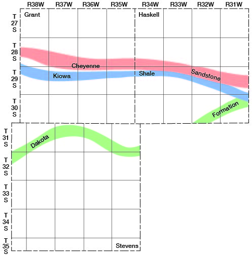
Cretaceous period--Sand now forming the Cheyenne sandstone was deposited in the northern part of Grant and Haskell Counties in early Cretaceous time (Pl. 3 and Fig. 8), probably by streams (Twenhofel, 1924, p. 19). Then an invasion of the sea brought about the deposition of the dark fossiliferous muds that formed the Kiowa shale. At the beginning of late Cretaceous time the sand and clay of the Dakota formation were laid down, probably in broad low lagoonal areas resembling the lower Mississippi Delta (Plummer and Romary, 1942, pp. 341-2). Although the Dakota sediments are nonmarine, Plummer and Romary believe they were deposited near sea level under conditions similar to those prevailing during the formation of the Mississippi Delta.
Figure 8--Map of Grant, Haskell, and Stevens counties showing the southern limits of the Dakota, Kiowa, and Cheyenne formations.
Marine deposits of limestone, chalk, and shale were laid down in southwestern Kansas in late Cretaceous time. The late Cretaceous sea probably covered much if not all of the Grant-Haskell-Stevens area, but subsequent erosion has removed most of the sediments that were deposited in it except a thin deposit of Graneros shale in northeastern Haskell County (Pl. 3). At the end of the Cretaceous period occurred the mountain-making movements that produced the Rocky Mountains and affected at least part of the High Plains section. At this time the Cretaceous and older beds probably were tilted to the slightly inclined position they now have.
Cenozoic Era
Tertiary period--A long period of erosion probably took place after the tilting of the Cretaceous and older beds in early Tertiary time. During this time the Cretaceous deposits lying above the Dakota formation were removed from the Grant-Haskell-Stevens area by erosion, leaving only the remnant of Graneros shale in northeastern Haskell County. Later, but still in early Tertiary time, the Syracuse anticline was being formed, causing a tilting of the rocks in northwestern Grant County (Pl. 3). At the beginning of the Pliocene epoch the deposits that comprise the Laverne formation (Gould and Lonsdale, 1926a; Frye and Hibbard, 1941) were laid down in parts of southwestern Kansas (Meade and Seward Counties) and northwestern Oklahoma (Beaver and Harper Counties). These deposits probably underlie much of the Grant-Haskell-Stevens area but they do not crop out in this area and seemingly cannot be distinguished from the overlying deposits by examination of well cuttings. Frye (1942, p. 23) suggested that these deposits were laid down in part in small lakes and on the flood plains of streams. The beds of coarse sand and gravel in the lower part were deposited by streams. Toward the end of Tertiary time, aggrading and laterally shifting streams deposited the silt, sand, and gravel comprising the Ogallala formation. The Ogallala formation in most, if not all, of the Grant-Haskell-Stevens area was then removed by erosion and deposits of the Rexroad (?) formation were laid down by streams (according to views of the author).
Quaternary period--Near the end of the Tertiary period or in the early part of the Quaternary period there probably was renewed folding of the Syracuse anticline accompanied by faulting. This period of deformation probably was the same as that which produced the major faulting in the Meade Basin in Meade County, Kansas (Frye and Hibbard, 1941). Subsequent to the period of deformation, extensive deposits of sand, gravel, silt, clay, and volcanic ash were laid down in the Grant-Haskell-Stevens area, and comprise the Pleistocene Meade formation.
During late Pleistocene time, aggrading streams flowing at the upland level spread fine sand and silt over their flood plains. These sediments, which comprise a part of the Kingsdown silt, probably were laid down over most of Grant, Haskell, and Stevens Counties. Erosion subsequently removed much of the water-laid part of the Kingsdown silt from the Grant-Haskell-Stevens area. In late Pleistocene and/or Recent time a thin deposit of loess was laid down over most of Grant and Haskell Counties and over the northern part of Stevens County. The loess deposits are considered the uppermost part of the Kingsdown silt.
During late Pleistocene and/or Recent time the high terrace deposits of the Cimarron River were laid down, the valley was deepened nearly to its present level, and the alluvium was deposited. More recently (primarily since the flood of May 1914) the channel of the Cimarron River has widened throughout most of its course in Grant, Haskell, and Stevens Counties. When this area was surveyed in 1874 the width of the channel of the Cimarron River was measured at each section line that the river crossed. The greatest measured width of the channel in this area in 1874 was 132 feet, at the west line of sec. 35, T. 30 S., R. 37 W., and the smallest width was 17 feet, at the west line of sec. 23, T. 30 S., R. 35 W. The average width at that time (average of more than 40 measurements) was about 47 feet. In 1939, however, the greatest width was more than 0.5 mile, the smallest width was about 125 feet, and the average width (based on measurements from aerial mosaics) was approximately 1,000 feet.
Other events in late Pleistocene and Recent time included the deposition of dune sand over most of Stevens County and parts of Grant and Haskell Counties and the formation of sinkholes, most of which are in the Stanton area in the vicinity of Bear Creek. This area probably subsided at the time of the folding and faulting of the Syracuse anticline. The sinkholes and depressions, which probably began to form after the major subsidence, continued to form through Recent time. The most recent sinkhole adjacent to the Syracuse anticline began to develop in western Hamilton County on December 18, 1929 (Bass, 1931).
Prev Page--Geography || Next Page--Ground Water
Kansas Geological Survey, Geohydrology
Web version May 2002. Original publication date July 1946.
Comments to webadmin@kgs.ku.edu
The URL for this page is http://www.kgs.ku.edu/General/Geology/Grant/04_geol.html