![]()
Prev Page--Cretaceous System || Next Page--Quaternary System
Geologic Formations, continued
Tertiary System
Laverne (?) formation
Test holes 15 and 16 in southern Finney County encountered beds of clay and clay-shale above the Dakota formation that are of questionable age. Lithologically these deposits are unlike both the underlying Dakota formation and the overlying Ogallala formation. They consist of tan, brown, and gray silty blocky clay and clay-shale (see logs 15 and 16). About 18 feet of brown medium sand to fine gravel was encountered 12.5 feet above the base of the clay beds in test hole 16. The thickness of the clay was 47.5 feet in teal hole 15 and 91.5 feet in test hole 16. A detailed microscopic study of the samples did not reveal any fossils.
On the basis of lithologic similarity and stratigraphic position these deposits are tentatively correlated with the Laverne formation, which is exposed above the Cretaceous rocks in southern Meade and Seward counties, Kansas, and in Beaver County, Oklahoma. The Laverne formation consists of gray, fine-grained, thin-bedded sandstone, some of which contains conglomerate; blue-gray to tan, even-bedded shale; and tan, soft, silty limestone which typically includes a thin bed of gray, dense limestone at the top (Frye and Hibbard, 1941, p. 398). Vertebrate fossils, ostracodes, and diatoms have been collected from the formation. According to Frye and Hubbard (1941, p. 403), the position of the Laverne formation unconformably below middle Pliocene deposits and the presence of lower Pliocene fossils in the upper part of the formation date it as lower Pliocene, and the lower part possibly is upper Mioccne in age.
Except for the sand and gravel phase encountered in test hole 16, the Laverne (?) formation in this area is relatively impermeable and probably would yield little or no water to wells.
Ogallala formation
The clay, silt, sand, and gravel below the terrace gravels, loess, dune sand, and alluvium and above the Cretaceous bedrock in Finney and Gray counties have in the past been referred to the Ogallala formation of Pliocene age. Sufficient evidence is available, however, to show that all of these clastic deposits are not of Pliocene age, but that a part of them are Pleistocene in age. A discussion of the age of the Ogallala formation is given below and a discussion of the age of the Pleistocene deposits is given on page 174.
The materials of Pliocene and Pleistocene age are lithologically similar; for this reason it was necessary to map them as a single unit in Finney and Gray counties (pl. 1). Although the contact between the Ogallala formation and the Pleistocene deposits could not be traced accurately in the field, sufficient data are available for describing them separately and for giving the approximate thickness and general distribution of each.
Character--The Ogallala formation consists chiefly of calcareous silts sands, and gravels, the proportions of which may differ greatly from place to place. In general, the materials making up the formation are poorly sorted, and gradations from one lithologic type to another may take place within short distances, both laterally and vertically. Individual beds of silt, sand, or gravel are characteristically lenticular and the individual lenses overlap one another irregularly (figs. 8 and 9). The materials are generally but not everywhere unconsolidated. Some of the beds of sand and gravel have been cemented with calcium carbonate and resemble old mortar (pl. HA).
Silt containing only very small amounts of clay make up the finer materials of the Ogallala formation. Fine sand generally is intermixed with the silt. Lenses of sandy silt ranging in thickness from a few inches to more than 50 feet are common and are likely to be found in any part of the formation. Many beds of silt are impregnated with lime giving them a white to light gray color. Where lime is not present, the color of the silt is tan, brown, buff, or gray.
Two test holes (4 and 5) in northwestern Finney County and one test hole (19) in northwestern Gray County encountered beds of mottled gray and yellow and greenish yellow noncalcareous clay at the base of the Ogallala formation. The thickness of these clays ranges from 18 feet in test hole 19 to 28.5 feet in test hole 5. Elms (1931, pp. 155-158) observed similar clays in the bower half of the Ogallala formation in Wallace County, Kansas, and named them Woodhouse clays.
Sand probably is the most abundant material in the Ogallala formation, and is found throughout the formation. Few beds occur in the formation that do not contain some sand, and many beds consist predominantly of sand. Although the degree of sorting varies, the beds of sand generally are poorly sorted, the texture ranging from fine- to coarse-grained. A few lenses of sand encountered by test drilling were relatively well sorted and free from other constituents, but most of them were poorly sorted, containing silt and some clay, and a few contained gravel. The sands consist predominantly of well-rounded to subangular quartz grains, but there are a few grains of feldspar and of dark minerals. Some of the sand is brown, red-brown, or light gray, but most of it is tan.
The coarser materials of the Ogallala formation are composed of fine to very coarse gravel. Gravels may be found in almost any part of the formation from the base to the top. In some areas in southwestern Kansas the gravels in many of the thicker sections are reported to be coarser, thicker, and more persistent at the base (Smith, 1940, p. 41). Coarse gravel was encountered at the base of the formation in only 2 of the 26 test holes drilled in Finney and Gray counties, sand and gravel was encountered at the base in 12 test holes, and silt and sand was encountered at the base in 12 test holes. Gravel found at or near the base of the formation generally contains abundant pebbles of weathered Cretaceous sandstone, limestone, chalk, and shale. Gravels higher up in the formation are composed of material derived from crystalline igneous and metamorphic rocks, such as granite, quartz, and feldspar. The pebbles are well rounded to angular, and are white, gray, brown, yellow, red, or red-brown. The gravels are rarely clean, but generally contain much sand or silt.
Caliche is common in the Ogallala formation and occurs as cementing material, pipy concretions, nodules, or irregular beds. The caliche is white to gray and generally is fairly soft. The thickness of bedded caliche in the Ogallala is very irregular and in this area ranges from a few inches to about 6 feet. The greatest thickness of caliche, 6 feet, was encountered in test hole 4 (see log 4). In some places, the Ogallala formation is capped by a hard limestone bed, which has been referred to as the capping limestone by Smith (1940, p. 44). It is commonly massive, weathers to a knobby, cavernous, or irregular surface, and has a maximum thickness of 5 feet. A bed of hard white limestone about 1 foot thick occurs at the top of a thin section in a draw in the SW sec. 12, T. 23 S., R. 28 W., Finney County (see measured section below). This limestone probably represents the capping limestone of other areas.
The following measured sections indicate the general lithology of the Ogallala formation at the surface:
| Section of Ogallala formation in a draw in the SW 1/4 sec. 12, T. 23 S., R. 28 W., Finney County. | Thickness (feet) |
|---|---|
| 3. Limestone, hard, white | 1.0 |
| 2. Silt, sandy, compact, reddish-brown, containing scattered pebbles of chalk | 4.0 |
| 1. Silt, loosely cemented, white and pink, containing many pebbles of chalk and limestone | 3.0 |
| Total thickness exposed | 8.0 |
| Section of Ogallala formation in the north bluff of Arkansas valley in the NE sec. 9, T. 25 S., R. 31 W., Finney County (pl. 11A). | Thickness (feet) |
|
|---|---|---|
| Surface covered with loose gravel. | ||
| Ogallala formation | ||
| 13. Sand, fine to medium, containing some coarse gravel; lime-cemented; light gray | 8.0 | |
| 12. Sand, coarse, and gravel; lime-cemented; containing zones and lenses at loose sand and gravel | 15.0 | |
| 11. Sand coarse, to very coarse gravel; lime-cemented; hard. Forms small ledge | 0.2 | |
| 10. Sand and gravel; loose | 0.5 | |
| 9. Sand, coarse, to very coarse gravel; lime-cemented; hard. Forms small ledge | 2.0 | |
| 8. Sand, fine to coarse, loose, yellow-tan | 1.0 | |
| 7. Sand, fine, to very coarse gravel; lime-cemented | 3.0 | |
| 6. Sand, fine, to very coarse gravel; loose; containing cemented root-shaped stringers | 2.5 | |
| 5. Silt, fine sand, and some coarse sand and gravel; lime-cemented; medium hard; lensing | 2.0 | |
| 4. Sand, fine, and silt; compact (no cementing agent); tan, | 1.0 | |
| 3. Sand, fine, and silt; lime-cemented; medium hard. Forms small ledge | 0.5 | |
| 2. Silt, and fine to medium sand; loose; reddish-tan; lensing | 1.5 | |
| 1. Sand, fine, lime-cemented, gray to white | 1.0 | |
| Total thickness exposed | 38.2 | |
Distribution and thickness--Because of the difficulty of distinguishing the Ogallala formation from the undifferentiated Pleistocene deposits, it is possible to give only the approximate areal distribution of the Ogallala. Exposures of the Ogallala formation occur above the Cretaceous rocks along Pawnee valley and its tributary draws and in places along the north bluff of the Arkansas valley east of Garden City. Most of the upland surface in Finney and Gray counties is underlain by deposits of Pleistocene age. The Ogallala formation, however, is found beneath younger deposits over most of the area. It is absent in the area in southern Gray County occupied by the buried Cretaceous hill shown on figures 7 and 9. Test hole 27 (log 27) on the south flank of the buried hill failed to encounter any beds belonging to the Ogallala formation. It is probable that this hill was at one time completely covered by sediments of the Ogallala formation, but that these sediments were removed during post-Ogallala erosion. The Ogallala also may be absent along parts of the west flank of the Finney trough near the Kearny County line, for most of the sediments encountered in test hole 5 (log 5) are thought to be Pleistocene in age.
The thickness of the Ogallala formation ranges within wide limits owing chiefly to the uneven surface on which the sediments were deposited. In Finney County, the Ogallala probably attains its greatest thickness in the buried trough in the northern part of the county (fig. 8 BB'). Test hole 3, which is near the deepest part of the trough, penetrated 160 feet of Ogallala below undifferentiated Pleistocene beds. The bedrock floor rises both toward the east and the west, so that the formation thins in both directions and probably is absent altogether in places on the west flank near the Kearny County line. The formation thins southward even though the bedrock floor declines in that direction. In test hole 16 on the Finney-Haskell County line, only 77 feet of sediments were penetrated that have been referred to the Ogallala formation. At one time the Ogallala formation probably was much thicker in southern Finney County, but most of it was removed by post-Ogallala erosion.
In Gray County, the Ogallala formation probably attains its greatest thickness just north of the Arkansas valley, where from 200 to 250 feet of the Ogallala was penetrated in test hole 20. The bedrock floor rises to the north and south and as a consequence the Ogallala is much thinner in the northern and southern parts of the county. In southern Gray County, the Ogallala thins to a feather-edge against the side of the buried Cretaceous hill. Test hole 24 in west-central Gray County penetrated 404 feet of Pliocene and Pleistocene sediments, but probably less than 200 feet of these sediments, belong to the Ogallala formation.
Origin--The materials of the Ogallala formation were deposited by widely shifting streams that had their origin in the Rocky Mountains. Smith (1940, pp. 85, 86) describes the mode of deposition of the Ogallala formation as follows:
"The deposition of the Ogallala was mainly of the channel and floodplain type. The coarser beds of sand, gravel, and grit represent channel deposits. ... The finer materials are best' interpreted as representing floodwater deposits formed by the overflow of shallow channels, perhaps approaching the character of sheet-floods locally. No recognizable deposits of eolian sand or silt have been found in the Ogallala in the area studied, but the presence of ventifacts indicates that there must have been appreciable wind action. ...
"The deposition of the Ogallala formation began with the change from stream degradation to aggradation. ... During the early stages of deposition, there was a topography of moderate relief. The main valleys were occupied by through-going streams from the Rocky Mountains, and the valley bottoms were mantled by normal floodplain deposits. ... Deposition probably began with the filling of stream channels, leading to more frequent overflow and thus to the upbuilding of the floodplains. This soon led to shifting of the channels themselves, and probably to the development of anastomosing patterns. As filling progressed, the valley flat overlapped farther and farther on the slopes of the bordering hills. ... Relief was lowered, the valley plains grew broader, and finally the divides were overtopped, and there followed overlapping and coalescing of the depositional zones of individual streams."
This manner of deposition explains the lenticuiar character of the materials and the many other irregular features of the formation.
Most of the materials in the Ogallala formation had their source in the Rocky Mountains. The silts and clays were derived from soils and weathering products in the mountain area. Most of the abundant limy material was derived from weathering of Paleozoic limestones and of calcic minerals in the crystalline rocks of the mountain area, but some of the limy material may have been provided by weathering in situ after deposition (Smith, 1940, p. 79). Theis, Burleigh, and Waite (1935, p. 1) agree that the coarse materials in the Ogallala were laid down by streams, but believe that the finer structureless sediments were deposited by the wind.
Age and correlation--The Ogallala formation was named and described by Darton (1899, pp. 732, 734) in the latter part of the last century, and its age was given as late Tertiary or Pliocene (?). The type locality of the formation is near Ogallala station in western Nebraska (Darton, 1920, p. 6).
The United States Geological Survey classifies the Ogallala formation as Pliocene. Smith (1940, pp. 75, 76), however, classified the Ogallala of southwestern Kansas as middle Pliocene insofar as it is represented by exposures at the surface. The overlying beds that contain upper Pliocene fossils in Meade County were assigned by Smith to the upper Pliocene and called the Rexroad formation. In 1941, Frye and Hibbard (1941, p. 407) placed all middle and upper Pliocene beds in Meade County in the Ogallala formation, and designated the upper Pliocene beds as the Rexroad member of that formation. The lithology of the Rexroad member is for the most part indistinguishable from that of the middle Pliocene beds. Although they may be present, no upper Pliocene beds were recognized in Finney and Gray counties.
To my knowledge, only one vertebrate fossil has been taken from the Ogallala formation in Finney and Gray counties. C.W. Hibbard (personal communication) reports that a Pliocene horse tooth was recovered from the Ogallala formation at a depth of about 50 feet during the drilling of a water well at Garden City. Vertebrate fossils also have been collected from the Ogallala formation in nearby areas. Waite (1942, p. 160) reports that during the drilling of an irrigation well in the SW sec. 6, T. 27 S., R. 26 W., Ford County, a Pliocene horse tooth was recovered from the Ogallala formation at a depth of 113 feet. The tooth was identified by C.W. Hibbard as a right molar of Pliohippus cf. interpolatus. Probably the largest collection of Ogallala fossils have come from excavations near Optima in Texas County, Oklahoma, about 17 miles south of the Kansas line, where, according to Schoff (1939, p. 62), about 10,000 horse teeth and between 900 and 1,000 bones of various animals, all of middle Pliocene age, were found.
Fossil grass and hackberry seeds collected from the Ogallala formation have been described by Elias (1932, pp. 333-340). Fragments of grass and hackberry seeds were found in test hole 1 in the southwestern corner of Scott County between depths of 103.5 and 119 feet. From comparisons with forms described by Elias, the grass seeds are believed to be Biorbia fossilia and the hackberry seeds are believed to be Celtis willistoni.
The Rexroad member in Meade County is more fossiliferous than the middle Pliocene part of the Ogallala, and has yielded snails, mollusks, fish, amphibian, reptile, bird, and mammal remains (Frye and Hibbard, 1941, p. 408).
Water-supply--Because the water-bearing properties of the Ogallala formation and undifferentiated Pleistocene deposits are similar and because it is difficult and in many places impossible to differentiate between the two in the subsurface, it is thought best to combine the descriptions of their water-bearing properties.
Tile sand and gravel of the Ogallala formation and the undifferentiated Pleistocene deposits are the most important sources of ground water in Finney and Gray counties. Most of the domestic and stock wells on the uplands, many of the irrigation and large industrial wells, and all of the public-supply wells derive water from these deposits. Although water is available at shallow depths in the alluvium in the Arkansas valley, many well owners have drilled their wells deeper to tap the Ogallala formation and undifferentiated Pleistocene deposits. All upland irrigation wells and a few irrigation wells in the Arkansas valley derive their water from the Ogallala and the Pleistocene deposits. These deposits also supply water to four springs (44, 45, 51, and 52) in the Pawnee River drainage basin (p. 87).
The finer materials are generally porous and hold much water, but are not permeable enough to yield water freely. The coarser materials, the gravels in particular, are very good water bearers and generally yield abundant supplies of water. The yields of wells tapping these deposits range from a few gallons a minute for small domestic and stock wells to as much as 1,770 gallons a minute for an irrigation well (24). Irrigation wells that obtain water from these deposits yield 10 to 141 gallons a minute per foot of drawdown.
The Ogallala formation and the Pleistocene deposits together make up a large underground reservoir that is only partly fibbed with water. Probably a greater thickness of the reservoir was saturated at one time, but streams such as Arkansas and Pawnee rivers have cut below the zone of saturation and are draining part of the water from the reservoir. In a small area in southern Gray County and in parts of northwestern Finney County, the Ogallala and the Pleistocene beds are comparatively thin and lie entirely above the water table. The thickness of saturated material, as shown by the cross sections in figures 8 and 9, ranges greatly. The greatest thickness of saturated material, about 360 feet, is in southern Finney County. Logs of test holes indicate that a large percentage of the saturated zone in the Ogallala and the Pleistocene deposits is composed of sand and gravel, so the amount of water available is large.
The samples of water analyzed from the Ogallala formation and undifferentiated Pleistocene deposits were of two types - the most common being a calcium bicarbonate water and the least common a calcium-magnesium sulfate water. Of the 33 samples of water analyzed from the Ogallala and undifferentiated Pleistocene beds, 28 were calcium bicarbonate waters. Of the 28 samples of calcium bicarbonate waters analyzed, 4 had less than 200 parts per million of total solids, 15 had between 200 and 300 parts, and 9 had between 300 and 509 parts. The calcium content of these samples was rather uniform; 27 samples had between 37 and 89 parts per million and the other sample had 101 parts. The bicarbonate content was between 171 and 200 parts per million in 10 samples, between 200 and 300 parts in 17 samples, and 347 parts in one sample.
The calcium-magnesium sulfate waters analyzed were in general more highly mineralized than the calcium bicarbonate waters. Two of the five samples of calcium-magnesium sulfate waters analyzed had 481 and 488 parts per million total solids, but three samples had 1,180, 1,500, and 1,576 parts. The calcium content of the five samples ranged from 88 to 207 parts per million and the sulfate content ranged from 205 to 867 parts per million. The three highly mineralized calcium-magnesium sulfate waters were collected from wells in the irrigation area north of Garden City. It is possible that the high sulfate content of these waters is due to surface irrigation water percolating into the ground-water reservoir.
Analyses of typical waters from the Ogallala formation and Pleistocene deposits are shown graphically in figure 19. Numbers 388 and 90 are typical of the calcium bicarbonate waters and number 114 is one of the harder, more highly mineralized calcium-magnesium sulfate waters.
The iron content of the water in the Ogallala and Pleistocene deposits in general seems to be relatively how. Of the 33 samples, 26 had less than 1 part per million of iron, 5 had from 1.0 to 2.9 parts, and one had 5.2 parts.
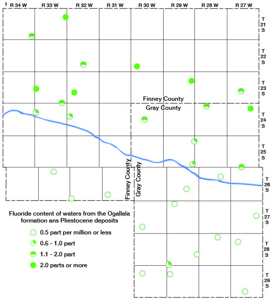
The fluoride content of the waters in the Ogallala and undifferentiated Pleistocene deposits was higher north of Arkansas River than south of the river. The areal distribution of fluoride in these waters is shown in figure 21. All but one of the analyses of water north of the river indicated more than 0.6 part per million of fluoride and about three-fourths of the analyses indicated more than 1 part per million, whereas all but one of the samples of water collected south of the river contained 0.5 part per million of fluoride or less.
Figure 21--Fluoride content of waters in the Ogallala formation and undifferentiated Pleistocene deposits in Finney and Gray counties.
Prev Page--Cretaceous System || Next Page--Quaternary System
Kansas Geological Survey, Geology
Web version April 2002. Original publication date Dec. 1944.
Comments to webadmin@kgs.ku.edu
The URL for this page is http://www.kgs.ku.edu/General/Geology/Finney/09_form4.html