![]()
Prev Page--Ground-water Resources 1 || Next Page--Wells, Test Holes, and Springs
Ground-water Resources
Availability of Ground Water
In Douglas County fresh ground water is known to occur in unconsolidated rocks locally to a depth of about 90 feet and in consolidated rocks locally to a depth of about 500 feet.
Except for cemented and consolidated zones in the fluvial and glaciofluvial deposits of Kansan age, the Pleistocene aquifers are all unconsolidated. They have a wide range of geologic and hydrologic characteristics and occur on the uplands, the valley sides, and as valley fillings. The texture of these deposits ranges from well-sorted sand and gravel to unsorted boulder clay.
The consolidated rock aquifers consist chiefly of sedimentary limestones, shales, and sandstones, which have a regional dip averaging about 20 feet per mile to the northwest. There is a pronounced, though gradual, change in the permeability of the consolidated rocks with depth. The relatively impermeable clay shales and dense limestones are slightly permeable and will yield small amounts of water to wells in the zone of weathering. The sandstones constitute the most important consolidated rock aquifers.
Unconsolidated Rock Aquifers
Alluvium and Deposits of Newman Terrace
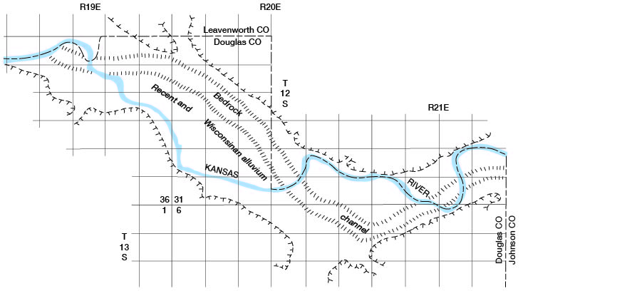
Kansas River valley--Large quantities of ground water are available from alluvium and Newman Terrace deposits in the Kansas River valley, the extent of which is shown on Plate 1. Logs of wells and test holes (at the end of this report) indicate that these deposits have a minimum thickness of about 45 feet in much of the valley and as much as 90 feet in the bedrock channel shown in Figure 9. The thickness of saturated water-bearing material ranges from about 25 feet to 65 feet or possibly more.
Figure 9--Approximate location of bedrock channel in Kansas River valley and present stream channel.
The saturated alluvial deposits have a wide range of permeability (Table 6), but most values of the coefficient of permeability are greater than 1,000 gpd per ft2, and in parts of the aquifer they are greater than 12,000 (Lohman, 1941, p. 36). The largest coefficient of transmissibility determined by pumping test (well 12-19-1dd) was 354,000 gpd per ft. Specific capacities of wells reported in Table 6, which range from 14 to 175 gpm per ft. of drawdown, probably are representative. Yields of wells in the alluvium generally range from 500 to 1,000 gpm, but some yields are as low as 100 gpm.
The average hydraulic gradient of the water table in this part of the Kansas River valley is about 2 1/2 feet per mile (Davis and Carlson, 1952, pl. 2; Dufford, 1958, fig. 3), but locally, as in the vicinity of the Bowersock Mill & Power Co. dam, at Lawrence, the gradient may be as much as 20 feet per mile (Lohman, 1941, p. 42).
Lohman computed the underflow in the Kansas River valley at Lawrence to be about 1,500,000 gpd, which he stated was probably too low because of the assumed hydraulic gradient used in the south half of the valley. Recharge in the valley was estimated by Lohman to be about 10 percent of the annual precipitation or about 64 million gallons on each square mile annually.
Industrial and municipal pumpage in the Lawrence area in 1955 was more than 5 mgd (Table 7), all of which was from parts of the alluvium and Newman Terrace deposits having relatively unfavorable hydrologic characteristics compared with those of the aquifer in the deep bedrock-channel area (Fig. 9). During peak irrigation periods an additional 3 to 5 mgd is pumped for irrigation in the Kansas River valley.
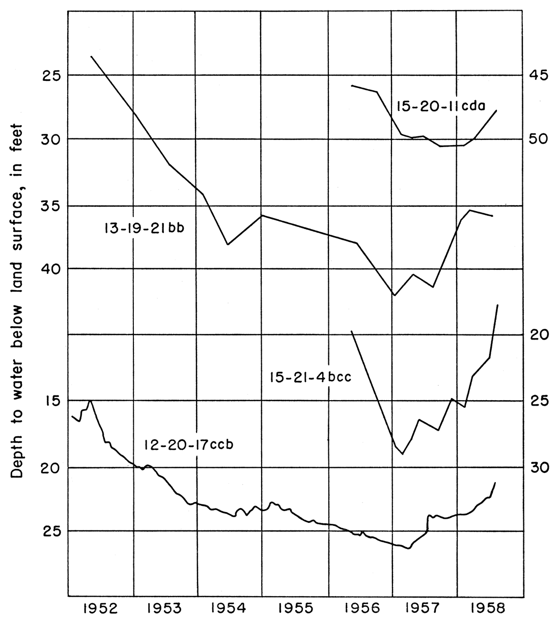
Fluctuations of the water table in well 12-20-17ccb, near the middle of the valley, shown in Figure 10 for the period February 1952 to August 1958, are the result of recharge to and discharge from the aquifer by natural and artificial means. Records of wells and test holes in these deposits are given in Table 8.
Figure 10--Hydrographs of four wells in principal aquifers of Douglas County.
The chemical character of ground water in the aquifer is indicated by the water analyses in Table 4. In general the ground water can be characterized as a very hard calcium bicarbonate water that contains much iron and has a pH range from 6.9 to 7.5.
Wakarusa River valley--Moderate quantities of ground water occur in the alluvium and Newman Terrace deposits of the Wakarusa River valley. The geologic and hydrologic characteristics of this aquifer are quite different from those in Kansas River valley, as shown in Plate 3 and in logs of test holes at the end of this report. Sandy and clayey silt compose most of the aquifer, but a thin send and gravel section lies at the base. Test holes indicate a thickness of about 50 to 70 feet of alluvial material. The average saturated thickness is 40 to 50 feet, but only 1 to 7 feet of silty sand and gravel is commonly available in which a well screen can be set and a well developed.
Yields of 50 to 100 gpm probably can be obtained, but in 1957 there were no wells of this capacity in operation. Drilled wells in this aquifer are difficult to screen and develop so that an objectionable quantity of very fine sand and silt is not pumped with the water. Many of the domestic wells are of large diameter and are dug just far enough below the water table to obtain a supply by slow infiltration to the well from the sandy and clayey silt in the upper and middle parts of the aquifer. The average hydraulic gradient of the water table in the alluvium and Newman Terrace deposits in the Wakarusa River valley is about 4 feet per mile.
The chemical character of the ground water is indicated by the water analysis of well 13-19-18dd (Table 4). The water is generally satisfactory for domestic use except for hardness and iron. Wells screened at the base of the aquifer where it directly overlies and is hydraulically connected with the Tonganoxie Sandstone member may obtain water containing more dissolved solids and chloride than that elsewhere.
Other stream valleys--Tributaries of Kansas and Wakarusa Rivers contain alluvium and Newman Terrace deposits but they are thin and generally do not yield large amounts of water to wells.
The lower parts of Little Wakarusa and Captain Creeks have 30 feet or more of alluvial deposits, containing a sand and gravel deposit in the basal part, that probably are capable of yielding 10 to 50 gpm to wells. Other streams have chiefly silty and clayey deposits ranging from about 10 to 50 feet in thickness and yielding ground water commonly at rates of 1 to 10 gpm.
The quality of ground water from deposits in these smaller valleys is generally satisfactory except for excessive hardness and iron content.
Deposits of Buck Creek Terrace
Buck Creek Terrace deposits are chiefly sandy clay and silt. Although the lower 2 to 10 feet generally includes poorly sorted sand and gravel containing considerable silt and clay, the aquifer does not yield ground water readily to wells.
Test holes drilled through these deposits (Pl. 2, 3) indicate a maximum thickness of about 68 feet and a maximum saturated thickness of about 55 feet in the Wakarusa River valley, where the deposits are most extensive.
Although it is difficult to keep very fine sand and silt from entering drilled wells constructed in the Buck Creek Terrace deposits, the aquifer is the source of satisfactory water supplies for several farms, from both dug and drilled wells. No wells were inventoried that would pump more than about 20 gpm, but supplies of 25 to 50 gpm probably could be obtained locally from property constructed and developed wells.
The quality of ground water from this aquifer is generally satisfactory for domestic use except for excessive hardness (Table 4) and locally high iron content.
Undifferentiated post-Kansan Alluvium and Terrace Deposits
Deposits younger than Kansan and which are equivalent in age to the alluvium and Newman Terrace and Buck Creek Terrace deposits in the larger valleys occur in many of the smaller tributary valleys but are not differentiated on Plate 1. These deposits range in thickness from about 10 to 40 feet. Because they are derived chiefly from the local rocks in the drainage area of the individual tributary and because of the predominance of shale in the area, most of the sediments are poorly sorted sandy clays and silts, although alluvium may be very sandy in tributaries draining areas of the Tonganoxie or Ireland Sandstone members or extensive Kansan deposits.
There is a wide range in the capacity of these deposits to store and transmit ground water, but small supplies of 1 to 10 gpm can generally be obtained from them for domestic and stock use. Because of the low yields, dug wells providing considerable storage in the well itself are more satisfactory than small-diameter drilled wells. Well 12-20-4bc (Table 8 and well log) is a representative well obtaining a domestic water supply from these deposits.
The chemical character of the ground water is similar to that obtained from other post-Kansan alluvial deposits in the larger valleys.
Kansan Deposits
Because of the wide range in thickness, extent, and character of the Kansan deposits, their ability to store and transmit water differs greatly from one locality to another. Deposits of clayey till, whether small dissected patches or extensive deposits, generally supply little or no water to wells. Fluvial outwash deposits, however, may be permeable and transmit water readily. Small dissected deposits generally are easily drained. This is illustrated by the Kansan outwash along Kansas River between Lawrence and Lakeview, where suburban development has resulted in many wells and test holes having been drilled for domestic water supplies. Some of these wells and test holes have been drilled through a very thin saturated zone of sand and gravel of the Grand Island Formation at the base of the deposits and yield satisfactory domestic supplies. Others may obtain small amounts of ground water from perched water bodies in the Sappa Formation or in post-Kansan alluvial and colluvial deposits. Still others penetrated the entire thickness of Kansan deposits without encountering any saturated material capable of yielding a domestic water supply and were drilled into the sandstone of the Stranger Formation, which underlies this area. As water in the Tonganoxie Sandstone member is salty in this area (test hole 12-19-26abb; Tables 4 and 8), such wells are failures unless at least a small amount of water is yielded by the Kansan deposits. If as much as 10 or 15 gallons of water per hour is obtained from the Kansan deposits in wells drilled into the Tonganoxie Sandstone member, this small amount of fresh water will move into the well and down into storage in the Tonganoxie because of the lower head in the sandstone. Water supplies of 200 to 300 gpd have been obtained from such wells, but if pumped heavily they may yield brackish or salty water.
In other areas of extensive Kansan deposits, such as the Hesper area, wells completed in saturated sand and gravel may yield large domestic and stock water supplies. Yields of 50 gpm probably can be obtained locally. Other wells, however, encountering only clay and sandy clay, or in marginal areas where the water table is below the Kansan deposits, may yield little or no ground water. Several small streams in the Hesper area have perennial flows maintained by ground-water discharge from the Kansan deposits.
The quality of water in Kansan deposits is indicated by the analyses in Table 4.
Consolidated Rock Aquifers
Limestone and Shale Aquifers
Limestone and shale are widespread over the county at or near the surface, and individual stratigraphic units are uniform in thickness and composition and are laterally continuous. In their unweathered state the limestone and shale are relatively impermeable and generally will not yield enough water to constitute a reliable water supply. At or near the surface, however, weathering processes tend to increase or enlarge the open spaces within the rocks, especially along joints, fractures, and bedding planes, so that locally these rocks may yield small supplies of ground water to shallow wells.
The permeability of weathered limestone and shale differs greatly from place to place. Effectiveness of recharge to and discharge from these rocks is importantly influenced by such factors as type and thickness of soil, vegetative cover, slope and topographic position, and thickness and extent of the weathered zone.
Haworth (1897, p. 15; 1913, p. 51) described water supplies obtainable from these rocks in Douglas County and, in particular, a ground-water supply developed by the University of Kansas in 1896 on the south slope of Mount Oread. Haworth's investigation revealed weathered shale and colluvial deposits as much as 40 feet thick on the middle part of the hillslope. A large dug well 19 feet deep, with galleries extending east and west along the base of the weathered shale zone, produced about "5,000 gallons a day almost all the year, and 10,000 in wet weather." Generally, large-diameter dug wells are more successful than drilled wells in such material, because of their large storage capacity. Static water levels in such wells may be within a few feet of the land surface in wet years and decline greatly in dry years. Successive years of deficient precipitation may cause wells constructed in these shallow aquifers to go dry.
The quality of water from the shallow aquifers is generally satisfactory for domestic use except for excessive hardness and iron content. The sanitary quality of ground water from such wells may be poor if the wells are not properly constructed or are located near sources of pollution.
Sandstone Aquifers
Calhoun, Tecumseh, and Kanwaka Shales--Each of these shale formations contains relatively thin intraformational channel sandstones, 5 to 30 feet thick locally, which yield small ground-water supplies to domestic wells. The sandstones have similar lithologic and hydrologic properties and are chiefly very fine to fine, micaceous, angular to subangular quartz sandstone. Although no permeability tests were made of these aquifers, their physical and lithologic similarity to sandstone of the Ireland and Tonganoxie Sandstone members suggests that their hydraulic properties might also be similar.
Wells 12-17-14aa and 12-18-3aa obtain water from sandstone in the Calhoun and Kanwaka Shales, respectively, which is representative of the quality and quantity of water generally obtainable from these aquifers (Tables 4 and 8). Yields of such wells, commonly 2 gpm or less, are satisfactory only for small domestic supplies.
Lawrence Shale--The Lawrence Shale contains the Ireland Sandstone member, an important sandstone aquifer in southern Douglas County which provides small to moderate' quantities of ground water. Many wells yield 5 to 50 gpm, and in most favorable areas 100 gpm probably can be obtained.
Both Baldwin and Wellsville obtain municipal water supplies from the Ireland Sandstone member. Logs of wells and test holes (at the end of this report) indicate that locally the Ireland Sandstone member is more than 115 feet thick. Figure 5 shows the principal area of occurrence of the sandstone, and Plate 1 indicates the areal extent of Lawrence Shale in this area. In the area of outcrop of the Ireland Sandstone member, ground water occurs chiefly under water-table conditions, and as much as 100 feet of saturated water-bearing material may be present locally. In the southwestern part of the county the aquifer is overlain by confining beds and the water is artesian, but the aquifer is generally not as thick as in southcentral and southeastern parts of the county.
The coefficient of permeability of the well-sorted, massive channel deposits ranges from about 100 to 350 gpd per ft2, but that of much of the aquifer is about 25 to 150 gpd per ft2.
Well 15-20-15ad (Baldwin well 8) penetrates about 19 feet of saturated water-bearing sandstone, which has a coefficient of permeability of about 340 gpd per ft2 Well 15-21-5ad (Wellsville well 3) penetrates 61 feet of Ireland Sandstone, which has a coefficient of permeability of about 125 gpd per ft2. These wells are pumped at about 45 and 25 gpm and have specific capacities of about 7.6 and less than 1 gpm per ft., respectively (Table 6). They are representative of the water supplies available from this aquifer.
Conditions are very favorable for recharge to the aquifer, especially in areas having friable and leached sandstone at or near the surface in the headwater areas of Tauy, Coal, and Captain Creeks. A considerable amount of ground water is discharged to tributaries of these streams, giving rise to small perennial streamflows and local marshy areas. The amount of ground water pumped from wells in this area is small compared with the amount discharged naturally.
The chemical quality of ground water in the Ireland Sandstone member is excellent in the outcrop or water-table area. It is a calcium magnesium bicarbonate water that is moderately low in dissolved solids. The municipal and domestic supplies obtained from it generally are not treated before use except for chlorination. Downdip, in southwestern Douglas County, the aquifer is confined, and the water contains more total dissolved solids. Instead of being a calcium magnesium bicarbonate water it is a soft sodium bicarbonate water, owing to natural softening by base exchange. The fluoride content of the ground water generally is greater in this area, and in many wells exceeds the recommended maximum of 1.5 ppm. The amount of chloride in the water of some wells that tap the Ireland Sandstone member is enough to give a salty taste. Chemical analyses of samples of ground water from the Lawrence Shale, chiefly from the Ireland Sandstone member, are given in Table 4.
Stranger Formation--The Stranger Formation contains the Tonganoxie Sandstone member, an important aquifer similar to the Ireland Sandstone in thickness, areal extent, and origin, but the two sandstones generally do not occur in the same geographic area except in southwestern Douglas County. The Vinland Shale member of the Stranger Formation locally contains a thin sandstone, which yields small amounts of ground water to a few wells. The sandstone in the Vinland commonly is very calcareous, and locally the voids between sand grains are almost completely filled with calcite. No data are available regarding the permeability of the sandstone in the Vinland Shale member, but it is probably very low. In some wells the sandstone in the Stranger Formation is not readily identifiable with the one in the Vinland Shale member or with the upper part of the Tonganoxie Sandstone member.
The Tonganoxie Sandstone member yields supplies of 5 to 50 gpm to many wells, and locally where most permeable may yield 50 to 100 gpm. It is the principal source of domestic and stock supplies in a belt several miles wide trending southwest nearly along the strike of the rocks from the Lawrence area to the southwest corner of the county (Fig. 4). Logs of wells and test holes indicate 70 feet of sandstone in the basal part of the Tonganoxie Sandstone member locally. Plate 1 indicates the outcrop area of the Stranger Formation; where it is broad, the Stranger Formation generally includes at least a few feet of sandstone of the Tonganoxie member.
In the outcrop area of the Tonganoxie Sandstone in the lower part of the Wakarusa River valley east and southeast of Lawrence, ground water in that aquifer is chiefly unconfined, but west and southwest of Lawrence the aquifer is confined between relatively impermeable limestone and shale beds and the water is artesian.
The coefficient of permeability of the Tonganoxie Sandstone probably has about the same range as that of the Ireland Sandstone, about 15 to 150 gpd per ft2, but locally well-sorted massive deposits are probablv much more permeable.
Overbrook municipal well 1 (15-17-12ac2) obtains water from the Tonganoxie Sandstone, and the results of a pumping test on this well are summarized in Table 6. The coefficient of transmissibility computed from this test was 1,620 gpd per ft. The thickness of the aquifer is about 90 feet; hence, the coefficient of permeability is about 18 gpd per ft2.
The hydraulic gradient in the artesian part of the Tonganoxie Sandstone member is approximately 7 feet per mile between well 15-17-1ac2 and well 13-19-27dd. The ground water is moving from southwestern Douglas County northeastward toward the Wakarusa River valley in the vicinity of Lawrence, where it discharges into alluvial deposits in the Wakarusa and Kansas River valleys.
Recharge to the nonartesian parts of the Tonganoxie Sandstone member south and east of Lawrence is chiefly from local precipitation in the outcrop area. Recharge to the artesian part of the aquifer in southwestern Douglas County is believed to result from hydraulic interconnection between Ireland Sandstone member and Tonganoxie Sandstone member in northwestern Franklin County. Ground water in the Tonganoxie in the artesian area of southwestern Douglas County generally is more mineralized downdip and also downgradient from southwestern Douglas County toward its discharge area in the vicinity of Lawrence.
The quality of water in the Tonganoxie Sandstone member ranges from good to bad. The water is salty in the lower, or downdip, part of the aquifer. In much of southwestern Douglas County the water is a soft to moderately hard sodium chloride water. It is of good quality in the southwestern corner of the county but is more brackish westward downdip and northeastward downgradient in the artesian area. In the water-table area southeast of Lawrence the water is generally a calcium bicarbonate water of good quality, although iron and fluoride may be present locally in objectionable amounts. Analyses of samples of ground water from Tonganoxie Sandstone and undifferentiated Stranger Formation are given in Table 4.
Rock Lake Shale--The Rock Lake Shale member locally contains fine and very fine sandstone, ranging in thickness from a featheredge to about 13 feet, which yields water to a few wells in eastern Douglas County. Table 4 includes analyses of water from two wells (14-20-22ba and 14-21-18ad) that obtain all or part of their water supply from this sandstone. As indicated by these analyses, the water is brackish but usable for livestock. Although a few wells reportedly yield water of good quality from this aquifer, other wells are known to yield water that is brackish. Conclusive data are not available, but it is likely that water in the aquifer west of R.20 E. is salty, and in parts of R. 20 and 21 E. is brackish. Yields of wells range from about 1 to 10 gpm.
Bonner Springs Shale--Tbe oldest sandstone known to yield water of usable quality in Douglas County is in the Bonner Springs Shale, which underlies the Plattsburg Limestone. Locally at well 14-20-22cc at least 16 feet of sandstone is present in the formation. Areas in which fresh water, or brackish water that is usable for stock, can be obtained probably are limited to parts of R. 20 and 21 E. Only two wells (14-20-22ba and 14-21-18ad) that obtained water from this aquifer were inventoried. Yields of 1 to 10 gpm can be obtained locally from this aquifer.
Other Aquifers
The Wyandotte Limestone, which underlies the Bonner Springs Shale, is the oldest formation known to be yielding usable (fresh or brackish) water to a well (14-21-16cc) in Douglas County. Older Pennsylvanian rocks have not been systematically studied or exploited for sources of ground water, but information obtained from drilling for oil and gas indicates that the water in the deeper Pennsylvanian rocks probably becomes progressively more mineralized with depth and may contain dissolved solids ranging from about 5,000 to 50,000 ppm, or even more.
Some unconfirmed reports indicate that some of the water in the pre-Pennsylvanian rocks is of a better quality than the water in the deep Pennsylvanian rocks. The "Hunton" limestone of Silurian and Devonian age is known to contain water of usable quality in parts of Brown and Doniphan counties in northeastern Kansas, and the Arbuckle Group, of Cambrian and Ordovician age, yields municipal water supplies in southeastern Kansas. Reliable analyses of ground water from pre-Wyandotte beds were not obtained during this investigation.
Utilization of Ground Water
Table 7--Use of ground water in Douglas County, 1955
| Daily use (gallons) | Total use, 1955 | Principal Aquifer | ||||
|---|---|---|---|---|---|---|
| Maximum | Minimum | Average | Millions of Gallons | Acre-feet | ||
| Public Suppliesa | ||||||
| Baldwin | 200,000 | 100,000 | 130,000 | 47 | 144 | Ireland Sandstone |
| Eudora | 150,000 | 50,000 | 80,000 | 29 | 89 | Alluvium |
| Lecompton | 10,000 | 3.6 | 11 | Alluvium | ||
| Overbrook | 40,000 | 10,000 | 20,000 | 7.3 | 22 | Tonganoxie Sandstone |
| Wellsville | 90,000 | 30,000 | 60,000 | 22 | 68 | Ireland Sandstone |
| Lawrence | 1,136,000 | 415b | 1,274 | Alluvium | ||
| Industrial Supplies | ||||||
| Cooperative Farm Chemicals Association | 1,290,000 | 471b | 1,445 | Alluvium and Newman Terrace Deposits | ||
| Kansas Power and Light Co, | 2,160,000 | 1,440,000 | 1,584,000 | 578b | 1,774 | Alluvium |
| Westvaco Mineral Products Division | 1,300,000 | 570,000 | 1,134,000 | 414b | 1,271 | Alluvium |
| National Alfalfa Dehydrating and Milling Co. | 1.5 | 4.6 | Alluvium and Newman Terrace Deposits | |||
| Irrigation suppliesc | 205 | 629 | Alluvium and Newman Terrace Deposits | |||
| Other pumpage | ||||||
| Rural domestic and stock, and miscelaneous | 200,000 | 73 | 224 | |||
| Total | 2,266.40 | 6,955.60 | ||||
Notes.
a. Data from State Board of Health and from water superintendents.
b. Metered.
c. Data from Division of Water Resources, Kansas State Board of Agriculture, and from well owners.
Public Supplies
Five towns--Baldwin, Eudora, Lecompton, Overbrook (Osage County) and Wellsville (Franklin County)--have well fields in Douglas County that provide the entire supplies for those towns. Lawrence utilizes both surface water and ground water for its public supply. Available logs of municipal wells and test holes indicated on Plate 2 are included at the end of this report.
Baldwin
Two dug wells and six drilled wells (Table 8; Pl. 2) supply water for the town of Baldwin. Seven of the wells, ranging from 40 to 60 feet in depth and from 8 to 120 inches in diameter, tap the Ireland Sandstone member of the Lawrence Shale, and one well 26 feet deep and 240 inches in diameter taps both the Ireland Sandstone and alluvial deposits along Spring Creek. Water is pumped from the well field to an elevated 200,000-gallon steel reservoir near the center of town.
Approximately 47 million gallons (144 acre-feet) of water was used in 1955 (Table 7). The water is of good quality, as shown by the analysis in Table 4. Chlorination is the only treatment given the water.
Eudora
The water supply of Eudora is obtained from two wells about 12 inches in diameter and 64 feet deep, which produce water from alluvium in the Kansas River valley. The average pumpage is about 80,000 gpd (Table 7); in 1955 approximately 29 million gallons (89 acre-feet) was pumped from the well field.
The newer of the two wells was not inventoried, but it is located in the same area and is of similar construction to the well inventoried (13-21-5db).
The water is of good quality except for more than 400 ppm of hardness (Table 4). Water is pumped from the well field to an elevated 50,000-gallon steel storage reservoir for distribution after being softened, treated for removal of iron, and chlorinated.
Lawrence
Both ground water and surface water are now used for the Lawrence municipal water supply, but originally only ground water and later only surface water was used (Lohman, 1938). Six wells ranging from 48.5 to 51.3 feet in depth are located north of the water plant in alluvium along Kansas River (Pl. 2). They are each equipped with 12-inch diameter screens, 18-inch casing, and 350 gpm capacity pumps. According to Robert Mounsey, city water superintendent (personal communication), in 1955 the well field supplied 414,817,600 gallons of water or about 34.6 percent of the total supply of 1,198,042,000 gallons. The quality of water in Kansas River changes with its stage and is affected by seasonal changes. Whenever the river water is excessively turbid or contains large quantities of taste- or odor-causing algae, the percentage of well water used is increased.
Normally the river water is somewhat softer than the ground water, but the ground water has a more nearly constant chemical quality and is free from turbidity, taste, and odor-causing organisms. The water is softened, chlorinated, and fluorinated at the treatment plant.
Lecompton
Lecompton obtains its water supply from a well (11-18-34bd) northwest of the town in the alluvium of the Kansas River valley. The well is 10 inches in diameter and 30 feet deep. Average pumpage is reported to be approximately 10,000 gallons a day (Table 6). In 1955 approximately 3.6 million gallons (11 acre-feet) was pumped.
The water is very hard and contains 0.31 ppm iron and manganese (Table 4) but otherwise is of good quality.
Overbrook
Two drilled wells in southwestern Douglas County supply water for Overbrook, which is in Osage County to the West. The wells tap the Tonganoxie Sandstone member of the Stranger Formation. Well 15-17-1ac1 (east well), is 507 feet deep and is eased with 412.5 feet of 6,14-inch iron casing. Well 15-17-1ac2 is 497 feet deep and is cased with 417 feet of 6 1/4-inch iron casing. Each well is equipped with a 35-gpm capacity submersible turbine pump. Water is pumped from the wells to an elevated 50,000-gallon steel reservoir at the east edge of town.
The water is of satisfactory quality as shown by the two analyses in Table 4, although it is hard and exceeds slightly the maximum values recommended by the U. S. Public Health Service for dissolved solids and iron. Analyses of water samples collected April 1, 1953, and December 12, 1955, indicate that the quality of water had improved slightly between those dates. Water treatment consists of chlorination.
The average daily usage is about 20,000 gallons, and in 1955 a total of about 7.3 million gallons (22 acre-feet) was pumped.
Wellsville
Prior to June 1956, two large dug wells, each 60 feet deep, and one 8,4-inch drilled well, 61 feet deep, provided the municipal water supply of the city of Wellsville, Franklin County (Pl. 2). In 1956 a fourth well (15-21-4bb), 100 feet deep, was drilled and added to the supply system. All the wells obtain water from the Ireland Sandstone member of the Lawrence Shale.
In 1955 an estimated 22 million gallons, or 68 acre-feet (Table 7), was pumped from the well field through a 50,000-gallon elevated steel storage reservoir near the center of town.
The water is of good quality as shown by the chemical analysis in Table 4. Chlorination is the only treatment given the water.
Industrial Supplies
Cooperative Farm Chemicals Association
Ammonium nitrate, urea solutions, anhydrous ammonia, and ammonia solutions are produced by the Cooperative Farm Chemicals Association plant east of Lawrence. Ground water is pumped from nine wells (Pl. 2) in alluvial deposits of the Kansas River valley for use principally in cooling processes, boiler feed, and products manufacture. A total of 471 million gallons of water (Table 7) was pumped from the well field in 1955. Consumptive use amounts to approximately half a million gallons per day During the last half of 1955 the plant also obtained 63 million gallons of water from the city of Lawrence.
Kansas Power and Light Co.
The Kansas Power and Light Co. generating plant between Lawrence and Lakeview is the largest single user of ground water in Douglas County. Six wells in the alluvium of the Kansas River valley provide 1,000 to 1,500 gpm continuously. In 1955 pumpage was approximately 578 million gallons, or 1,774 acre-feet (Table 7).The water is used chiefly for cooling.
National Alfalfa Dehydrating and Milling Co.
The National Alfalfa Dehydrating and Milling Co. has dehydrators at Lakeview and Midland, which operate during the growing season. The Midland plant has storage and processing facilities that operate throughout the year. Approximately 1.5 million galIons of water is used annually by the two dehydrators.
Westvaco Mineral Products Division Food Machinery & Chemical Corp.
Sodium phosphate, phosphoric acid, and dry ice are manufactured by the Westvaco Mineral Products Division in north Lawrence. Ground water, obtained from six wells in the alluvium of the Kansas River valley, is used for cooling. In 1955 the well field was Pumped at a rate of 800 to 900 gpm about 80 percent of the year, and pumpage totaled 414 million gallons (1,271 acre-feet). About 10 to 15 percent of the water pumped is consumed.
Irrigation Supplies
The first irrigation of field crops in the Kansas River valley was probably in the middle 1930's. During the 1940's rainfall was generally above normal and interest in irrigation declined. The years 1952 to 1956, inclusive, were drought years and interest in irrigation was revived. In 1955 an estimated 629 acre-feet of water was pumped from wells and water-table pits in the Kansas River valley in Douglas County, to irrigate 656 acres of crops, principally corn and alfalfa. In 1957, 1,080 acres was irrigated from wells or water-table pits. Irrigation water is most commonly distributed by sprinkler systems, and the wells are pumped at rates of 350 to 1,000 gpm.
Water analyses available indicate that the ground water is satisfactory for crops most commonly irrigated. Ground water in the Kansas River valley generally has a low sodium (alkali) hazard and a medium or high salinity hazard. Crops of moderate salt tolerance, such as corn, alfalfa, wheat, oats, and potatoes, can be irrigated without special practices, but high-salinity water cannot be used on soils having restricted drainage. For a more thorough discussion of the suitability of water for irrigation the interested reader is referred to Agriculture Handbook 60 of the U. S. Department of Agriculture.
No ground-water irrigation is practiced outside the Kansas River valley, as sufficiently high yields generally are not obtainable elsewhere in the county.
Domestic and Stock Supplies
Several hundred water supplies for domestic and stock needs are obtained from wells and springs in Douglas County. During 1955, a drought year, many farm, domestic, and stock supplies were inadequate, and much water was hauled from municipal supplies and from Kansas Emergency Relief Committee wells. It is estimated that, exclusive of water from municipal sources, about 200,000 gpd of water was obtained from wells and springs. The total 1955 use is estimated at 73 million gallons or 224 acre-feet (Table 7).
Summary
Pumpage of ground water increased more than 400 percent between 1950 and 1956, chiefly as a result of industrial and irrigation developments. Additional large increases for industry and agriculture are likely to result in the next few years; most of the ground water will be obtained from alluvium and Newman Terrace deposits in the Kansas River valley.
Prev Page--Ground-water Resources 1 || Next Page--Wells, Test Holes, and Springs
Kansas Geological Survey, Geohydrology of Douglas County
Web version Aug. 1999. Original publication date Dec. 1960.
Comments to webadmin@kgs.ku.edu
The URL for this page is http://www.kgs.ku.edu/General/Geology/Douglas/gw04.html