![]()
Prev Page--Contents || Next Page--Geologic Setting
Introduction
Scope of Investigation
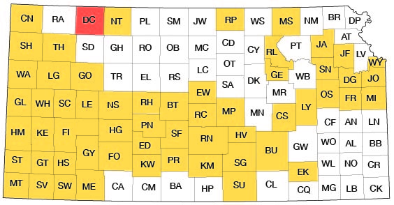
This report of a study of the ground-water resources of Decatur County, Kans., was made as part of the ground-water program of the State Geological Survey of Kansas and the United States Geological Survey, in cooperation with the Division of Water Resources of the Kansas State Board of Agriculture and the Environmental Health Services of the Kansas State Department of Health. The status of the program and the location of Decatur County are shown on figure 1.
Figure 1--Index map of Kansas showing area described in this report and areas covered by other online geologic reports, as of Oct. 2008. For additional information, please visit the KGS Geologic Maps of Kansas Page.
A test-drilling program was started in northwestern Kansas in 1952. Data obtained from this program are included in this report. About 3 months during the summer and fall of 1962 were spent in the field by the author gathering additional data on which this report is based. The areal geology was mapped from field observations and from stereoscopic study of aerial photographs obtained from the U.S. Department of Agriculture. Data on the 355 water wells inventoried as a part of this project are given in table 6. Logs of 35 wells and test holes are given at the end of the report. Aquifer tests made in the alluvial deposits in the principal valleys were used to compute the coefficients of transmissibility. Samples of water collected from representative wells were analyzed under the supervision of Howard A. Stoltenberg, Chemist, in the Sanitary Engineering Laboratory of the Kansas State Department of Health.
Previous Investigations
Studies related to the geology or to the ground-water resources of Decatur County and adjacent areas have been made by several people. Adams (1898) has given a historical summary of the early studies of the Cretaceous rocks in Kansas. Williston (1897) discussed the Pleistocene deposits of Kansas. Haworth contributed reports on the physiography (1897a), Tertiary deposits (1897b), and ground water (1897c) in western Kansas. Studies of the High Plains and their ground-water resources were made by Johnson (1901, 1902) and Darton (1905). In a special report on well waters in Kansas, Haworth (1913) discussed the water-bearing characteristics of deposits in western Kansas. Elias (1937) reported on the geology of Decatur and Rawlins Counties with special reference to water resources. A report by Byrne and others (1950) describes the occurrence of construction materials in Decatur County. Frye and Leonard (1952) discussed the Pleistocene geology of Kansas; and Frye, Leonard, and Swineford (1956) discussed the Ogallala Formation of northern Kansas. Ground-water studies in counties that border Decatur County were made by Frye (1945), Frye and Leonard (1949), Prescott (1955), Bayne (1956), and Walters (1956).
Well-Numbering System
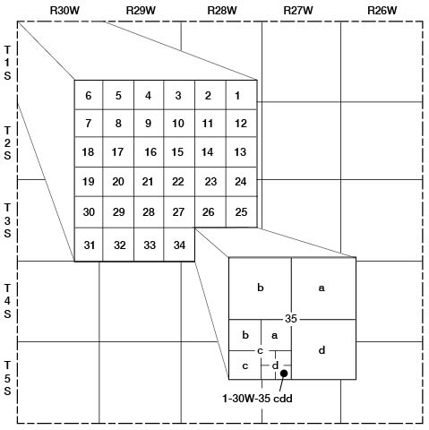
The locations of wells and test holes in this report are designated according to General Land Office surveys in the following order: township, range, section, quarter section, quarter-quarter section, and quarter-quarter-quarter section (10-acre tract). The quarter sections, quarter-quarter sections, and 10-acre tracts are designated a, b, c, and d in a counter-clockwise direction beginning in the northeast quadrant. For example, well 1-30W-35cdd is in the SE SE SW sec. 35, T. 1 S., R. 30 W. (fig. 2). If more than one well or test hole is located in the same 10-acre tract, the location numbers are followed by serial numbers in the order in which they were inventoried.
Figure 2--Diagram illustrating well-numbering system used in this report.
Topography and Drainage
Decatur County, an area of about 900 square miles, is in the High Plains section of the Great Plains physiographic province (Frye and Schoewe, 1953). Gently rolling uplands moderately dissected by small drainageways comprise much of the county. Four principal streams (Beaver Creek, Sappa Creek, Prairie Dog Creek, and North Fork Solomon River) cross the county in a northeasterly direction. The slopes into the valleys of the principal streams tend to be gentle, but they are steeper and more rugged in most places along the south side of Beaver Creek valley in the northwestern part of the county. The general slope of the land surface of Decatur County is eastward. The total topographic relief is about 640 feet. The lowest attitude of land surface, about 2,330 feet above mean sea level, is in the channel of Sappa Creek at the Decatur County-Norton County line; the highest altitude, about 2,970 feet above mean sea level, is in the uplands in the southwestern part of the county between Sappa Creek and Prairie Dog Creek.
Climate
Decatur County has a subhumid to semi-arid climate characterized by slight to moderate precipitation, moderately high average wind velocity, and rapid evaporation. The mean annual precipitation at Oberlin is 18.42 inches, and the mean annual temperature is 53.2°F (table 1). The average length of the growing season is 160 days. The average date of the last killing frost is May 2, and the average date of the first killing frost is October 9. About 70 percent of the precipitation occurs during the growing season. Rainfall is erratic, however, sometimes coming as storms of 3 inches or more; at other times, several weeks may pass without an appreciable amount of precipitation.
Table 1--Monthly and annual precipitation and temperature at Oberlin, 1931-60 (from records of U.S. Weather Bureau).
| Month | Mean precipitation, in inches |
Mean temperature, °F |
|---|---|---|
| January | 0.40 | 28.2 |
| February | .49 | 32.4 |
| March | 1.09 | 39.7 |
| April | 1.75 | 52.0 |
| May | 2.91 | 62.1 |
| June | 3.20 | 72.7 |
| July | 2.72 | 78.8 |
| August | 2.35 | 77.3 |
| September | 1.57 | 68.0 |
| October | .95 | 55.6 |
| November | .60 | 39.5 |
| December | .39 | 31.5 |
| Mean annual, 1931-60 |
18.42 | 53.2 |
According to the U.S. Census in 1960, Decatur County had a population of 5,778, an average of 6.4 persons per square mile as compared to a state average of 26.6 persons. [Note: Decatur County population was listed as 3,472 in 2000 U.S. census, with a density of 3.9 (32.9 for the state) (KU Institute for Policy & Social Research).] Oberlin, the county seat, had a population of 2,337 [1,994 in 2000]. Other cities and their 1960 populations are: Norcatur, 302 [169 in 2000]; Jennings, 292 [146 in 2000]; and Dresden, 134 [51 in 2000].
Prev Page--Contents || Next Page--Geologic Setting
Kansas Geological Survey, Geology
Placed on web Oct. 8, 2008; originally published Dec. 1969.
Comments to webadmin@kgs.ku.edu
The URL for this page is http://www.kgs.ku.edu/General/Geology/Decatur/02_intro.html