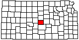
Rice County
|
|
Rice County |
|
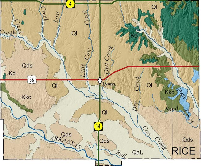
Because no detailed digital mapping has been done for this county, this map is extracted from the state geologic map.
|
|
Bayne, C.K., and Ward, J.R., 1974, Geology and hydrology of Rice County, central Kansas: Kansas Geological Survey, Bulletin 206(3), 17 p. [available online]
As part of U.S. Geological National Cooperative Geologic Mapping Program (STATEMAP), the KGS has produced 7 1/2 minute quadrangle maps as part of the Rice County geologic mapping project.
Johnson, W.C., and Koop, A.N., 2015, Preliminary surficial geology of the Rice County portion of the Alden quadrangle, Kansas: Kansas Geological Survey, Open-file Report 2015-5, 1 sheet, scale 1:24,000, unpublished [PDF available online]
Johnson, W.C., and Koop, A.N., 2015, Preliminary surficial geology of the Rice County portion of the Alden NW quadrangle, Kansas: Kansas Geological Survey, Open-file Report 2015-6, 1 sheet, scale 1:24,000, unpublished [PDF available online]
Johnson, W.C., and Koop, A.N., 2015, Preliminary surficial geology of the Chase quadrangle, Rice County, Kansas: Kansas Geological Survey, Open-file Report 2015-8, 1 sheet, scale 1:24,000, unpublished [PDF available online]
Johnson, W.C., and Koop, A.N., 2015, Preliminary surficial geology of the Rice County portion of the Chase NW and Holyrood quadrangles, Kansas: Kansas Geological Survey, Open-file Report 2015-9, 1 sheet, scale 1:24,000, unpublished [PDF available online]
Johnson, W.C., and Koop, A.N., 2015, Preliminary surficial geology of the Rice County portion of the Sterling quadrangle, Kansas: Kansas Geological Survey, Open-file Report 2015-10, 1 sheet, scale 1:24,000, unpublished [PDF available online]
Johnson, W.C., and Philbin, A.W., 2016, Preliminary surficial geology of the Chase NE quadrangle and the Rice County portion of the Lorraine quadrangle, Kansas: Kansas Geological Survey, Open-file Report 2016-14, 1 sheet, scale 1:24,000, unpublished [PDF available online]
Johnson, W.C., and Philbin, A.W., 2016, Preliminary surficial geology of the Lyons NW quadrangle and the Rice County portion of the Geneseo quadrangle, Kansas: Kansas Geological Survey, Open-file Report 2016-15, 1 sheet, scale 1:24,000, unpublished [PDF available online]
Johnson, W.C., and Philbin, A.W., 2016, Preliminary surficial geology of the Lyons quadrangle, Rice County, Kansas: Kansas Geological Survey, Open-file Report 2016-16, 1 sheet, scale 1:24,000, unpublished [PDF available online]
Johnson, W.C., Schlagel, N.A., and Dunham, J.W., 2017, Preliminary surficial geology of the Little River quadrangle and the Rice County portion of the Crawford quadrangle, Kansas: Kansas Geological Survey, Open-file Report 2017-21, 1 sheet, scale 1:24,000, unpublished [PDF available online]
Johnson, W.C., Schlagel, N.A., and Dunham, J.W., 2017, Preliminary surficial geology of the Lyons SE quadrangle, Rice County, Kansas: Kansas Geological Survey, Open-file Report 2017-22, 1 sheet, scale 1:24,000, unpublished [PDF available online]
Johnson, W.C., Schlagel, N.A., and Dunham, J.W., 2017, Preliminary surficial geology of the Rice County portion of the Windom SW quadrangle, Kansas: Kansas Geological Survey, Open-file Report 2017-23, 1 sheet, scale 1:24,000, unpublished [PDF available online]
Johnson, W.C., Schlagel, N.A., and Dunham, J.W., 2017, Preliminary surficial geology of the Rice County portions of the Windom and Langley quadrangles, Kansas: Kansas Geological Survey, Open-file Report 2017-24, 1 sheet, scale 1:24,000, unpublished [PDF available online]
Cartographic Services, Kansas Geological Survey
Updated December 9, 2020
Comments to webadmin@kgs.ku.edu
URL=http://www.kgs.ku.edu/General/Geology/County/rs/rice.html