Lincoln County
|
|
Lincoln County |
|
Help us direct future mapping activities by leaving your voluntary comments here.
Comments about how you are using these maps are especially appreciated. Thank you!
|
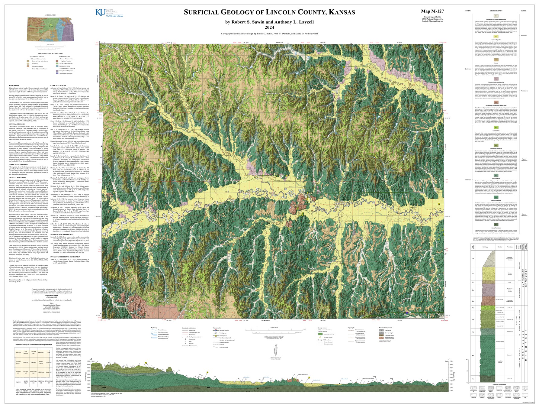
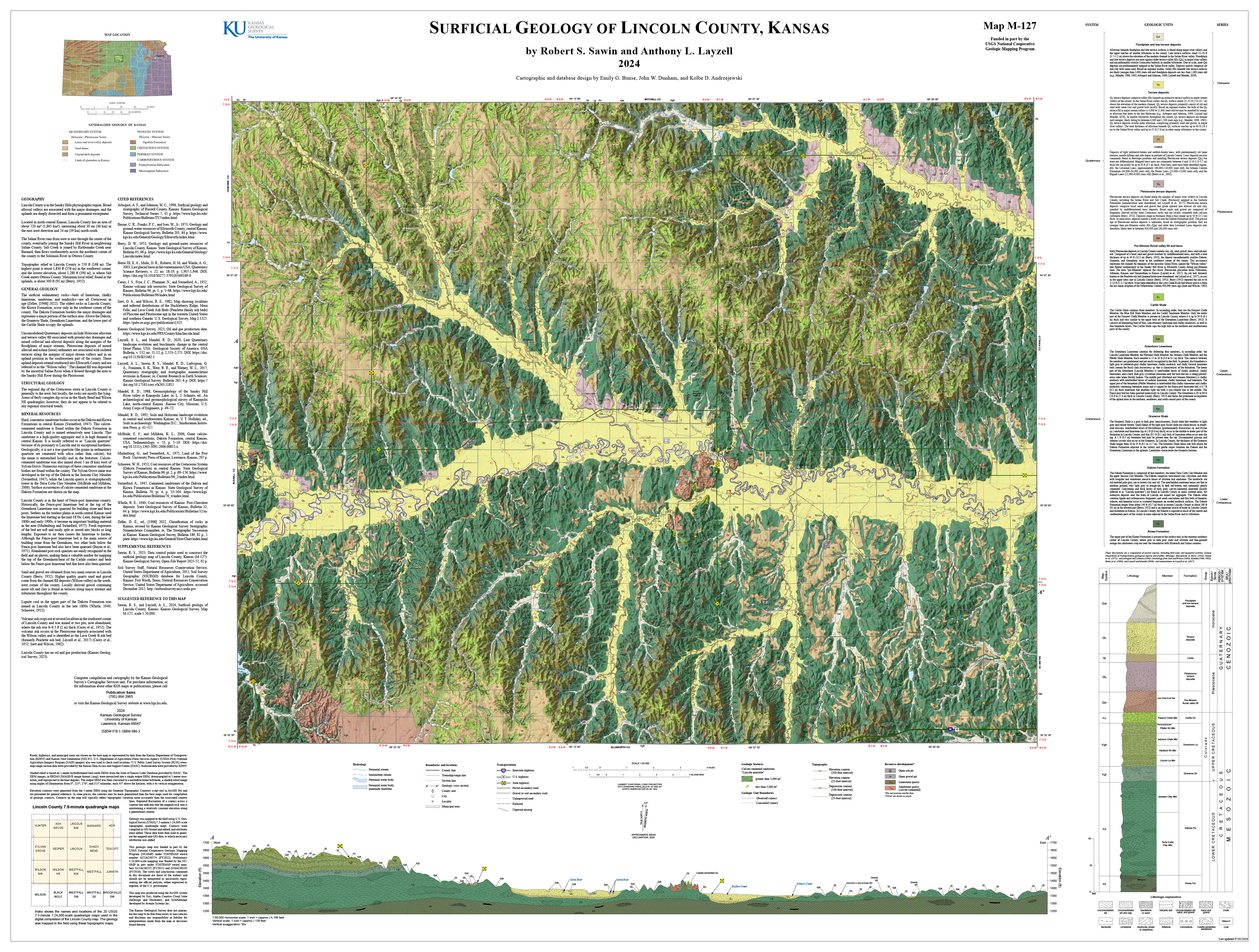
Sawin, R. S., and Layzell, A. L., 2024, Surficial geology of Lincoln County, Kansas: Kansas Geological Survey, Map M-127, scale 1:50,000.
Sawin, R. S., 2023, Data control points used to construct the surficial geology map of Lincoln County, Kansas (M-127): Kansas Geological Survey, Open-File Report 2023-52, 62 p. [PDF available online]
Berry, D.W., 1952, Geology and ground-water resources of Lincoln County, Kansas: Kansas Geological Survey, Bulletin 95, 96 p. [available online]
Sawin, R. S., 2023, Preliminary surficial geology of Lincoln County, Kansas: Kansas Geological Survey, Open-File Report 2023-41, scale 1:50,000, unpublished. [PDF available online]
As part of U.S. Geological National Cooperative Geologic Mapping Program (STATEMAP), the KGS has produced 7 1/2 minute quadrangle maps as part of the Lincoln County geologic mapping project.
Sawin, R.S., 2016, Preliminary surficial geology of the Lincoln County portion of the Juniata and Brookville SW quadrangles, Kansas: Kansas Geological Survey, Open-file Report 2016-5, 1 sheet, scale 1:24,000, unpublished [PDF available online]
Sawin, R.S., 2016, Preliminary surficial geology of the Lincoln quadrangle, Lincoln County, Kansas: Kansas Geological Survey, Open-file Report 2016-6, 1 sheet, scale 1:24,000, unpublished [PDF available online]
Sawin, R.S., 2016, Preliminary surficial geology of the Lincoln County portion of the Sylvan Grove quadrangle, Kansas: Kansas Geological Survey, Open-file Report 2016-8, 1 sheet, scale 1:24,000, unpublished [PDF available online]
Sawin, R.S., 2016, Preliminary surficial geology of the Vesper quadrangle, Lincoln County, Kansas: Kansas Geological Survey, Open-file Report 2016-9, 1 sheet, scale 1:24,000, unpublished [PDF available online]
Sawin, R.S., 2016, Preliminary surficial geology of the Westfall quadrangle and the Lincoln County portion of the Westfall SE quadrangle, Kansas: Kansas Geological Survey, Open-file Report 2016-10, 1 sheet, scale 1:24,000, unpublished [PDF available online]
Sawin, R.S., 2016, Preliminary surficial geology of the Westfall NW quadrangle and the Lincoln County portion of the Westfall SW quadrangle, Kansas: Kansas Geological Survey, Open-file Report 2016-11, 1 sheet, scale 1:24,000, unpublished [PDF available online]
Sawin, R.S., and Dunham, J.W., 2017, Preliminary surficial geology of the Lincoln County portion of the Ada Quadrangle, Kansas: Kansas Geological Survey, Open-file Report 2017-11, 1 sheet, scale 1:24,000, unpublished [PDF available online]
Sawin, R.S., and Dunham, J.W., 2017, Preliminary surficial geology of the Lincoln County Portion of the Ash Grove Quadrangle, Kansas: Kansas Geological Survey, Open-file Report 2017-12, 1 sheet, scale 1:24,000, unpublished [PDF available online]
Sawin, R.S., and Dunham, J.W., 2017, Preliminary surficial geology of the Lincoln County Portion of the Barnard Quadrangle, Kansas: Kansas Geological Survey, Open-file Report 2017-13, 1 sheet, scale 1:24,000, unpublished [PDF available online]
Sawin, R.S., and Dunham, J.W., 2017, Preliminary surficial geology of the Lincoln County Portion of the Hunter Quadrangle, Kansas: Kansas Geological Survey, Open-file Report 2017-14, 1 sheet, scale 1:24,000, unpublished [PDF available online]
Sawin, R.S., and Dunham, J.W., 2017, Preliminary surficial geology of the Lincoln County Portion of the Lincoln NW Quadrangle, Kansas: Kansas Geological Survey, Open-file Report 2017-15, 1 sheet, scale 1:24,000, unpublished [PDF available online]
Sawin, R.S., and Dunham, J.W., 2017, Preliminary surficial geology of the Lincoln County Portion of the Tescott Quadrangle, Kansas: Kansas Geological Survey, Open-file Report 2017-16, 1 sheet, scale 1:24,000, unpublished [PDF available online]
Sawin, R.S., and Dunham, J.W., 2017, Preliminary surficial geology of the Lincoln County Portion of the Wilson NW and Wilson Quadrangles, Kansas: Kansas Geological Survey, Open-file Report 2017-17, 1 sheet, scale 1:24,000, unpublished [PDF available online]
Sawin, R.S., and Dunham, J.W., 2017, Preliminary surficial geology of the Shady Bend quadrangle, Lincoln County, Kansas: Kansas Geological Survey, Open-file Report 2017-18, 1 sheet, scale 1:24,000, unpublished [PDF available online]
Sawin, R.S., and Dunham, J.W., 2017, Preliminary surficial geology of the Wilson NE quadrangle and the Lincoln County portion of the Black Wolf quadrangle, Kansas: Kansas Geological Survey, Open-file Report 2017-19, 1 sheet, scale 1:24,000, unpublished [PDF available online]
Cartographic Services, Kansas Geological Survey
Updated February 27, 2024
Comments to kgs-webadmin@ku.edu