


Kansas Geological Survey, Open-File Rept. 96-1a
Proposed Management Areas--Page 10 of 16
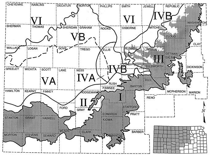
Figure 6. Proposed management areas of the Dakota aquifer in Kansas. The boundaries of these areas are defined by their hydrogeologic and water quality characteristics.
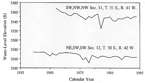
Many of the high-yielding wells in the upper and lower Dakota are located in this management area, especially in southwestern Kansas. The hydraulic head declines from development have generally been low in comparison to the declines experienced in the High Plains aquifer. The hydrographs of wells nearer the outcrop areas of the Dakota in southwestern Stanton and southern Hamilton counties show declines of 30 ft or less for the period from 1965 to the present. In most cases, water-level declines in these wells are less than 15 ft (Figure 7).
Figure 7. Hydrographs of Dakota wells located in SW, NW, NW Sec 31, T. 31 S., R. 41 W., and NE, SW, SW Sec. 12, T. 30 S., R. 42 W.
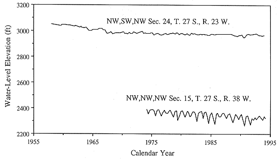
In northwestern Grant county, the hydrograph of a Dakota well located in NW, NW, NW Sec. 15, T. 27 S., R. 38 W. shows approximately 43 ft of decline from 1965-1994, whereas a High Plains aquifer well located approximately 7 mi south in SE, SE, SE Sec. 12, T. 28 S., R. 38 W. shows a much larger decline of approximately 70 ft during the 1965-1989 period of record. Similar water-level declines have been experienced in Finney County south of Garden City for the 1965-1994 period. To the east in the Arkansas River valley near Dodge City, the hydrograph of a well shows that hydraulic heads in the Dakota have declined approximately 40 ft since 1974 (Figure 8). However, in adjacent Kiowa County, the hydrograph of an observation well in T. 27 S., R. 20 W. shows only very minor fluctuations of hydraulic head over the period of record from 1969-1994 (Figure 8).
Figure 8. Hydrographs of Dakota wells located in NW, NW, NW Sec 15, T. 27 S., R. 38 W., and NW, SW, NW, Sec. 24, T. 27 S., R. 23 W.
These patterns of decline in the Dakota in the western part of this management area reflect the downward trend in water levels the overlying hydraulically connected aquifer. They may also indicate that withdrawals generally exceed recharge to the Dakota and thus water is being produced from storage. Hydraulic-head declines in the Dakota are smaller in Stanton and Morton and Kiowa counties because water is being produced from the Dakota at rates that either slightly exceed or equal the natural discharge from the Dakota to the High Plains aquifer.
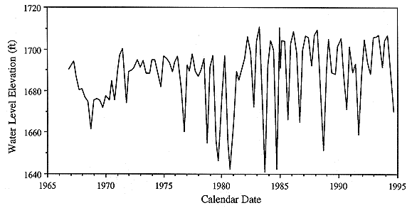
To the northeast, the hydrograph of a high-yielding well in southwestern Ellsworth County shows only seasonal fluctuations due to pumping and recovery of hydraulic head over a period of nearly 30 yrs (Figure 9). The observation well is located within 2 mi of City of Lorraine municipal supply well and is within a Dakota wellfield operated by a pipeline company. In this part of Ellsworth County, all of the Dakota wells are screened in a 100-ft thick channel sandstone in the Dakota Formation. The sandstone aquifer is overlain by a 50 ft of interbedded sandstone and siltstone and water-saturated Quaternary deposits that fill the Chase channel, a NW-SE trending buried valley in southern Ellsworth and northern Barton counties. The average pumping rate for all of the Dakota wellfield is approximately 590 gal/min. The lack of a downward trend in hydraulic-head over time suggests that ground-water withdrawals from the aquifer have not exceeded the combined effects of induced recharge and reduced discharge from local flow systems, and leakage from overlying sources.
Figure 9. Hydrographs of a well located in SW, SW, NW Sec 21, T. 17 S., R. 9 W., Ellsworth County.
At the present rate of development, a well-spacing of 0.5 miles is most appropriate since the Dakota is not as prolific an aquifer as the overlying High Plains aquifer. More stringent spacing coupled with regulated rates of withdrawal may be required locally as more wells tap into the aquifer.
Previous page--Surface-Casing Requirements ||
Next page--Management Area II
Start of this report ||
Table of Contents