


Kansas Geological Survey, Open-File Rept. 91-1a
Pre-Graneros Paleogeography--Appendix 1
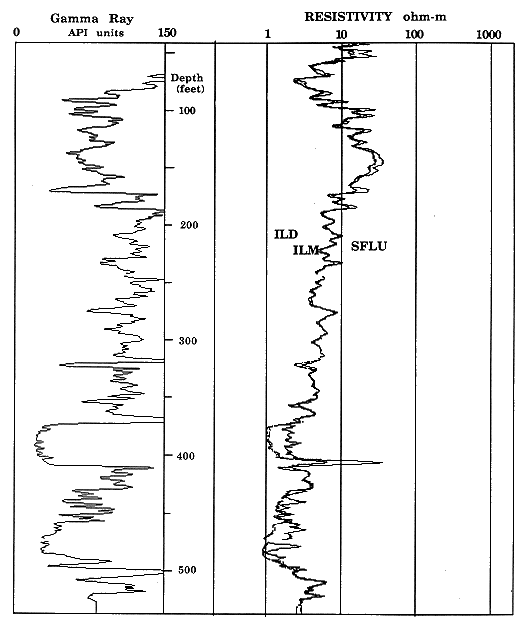
The Kenyon #1 test hole was drilled during September, 1989 in the southern half of, SE, SE Sec. 24, T. 4 S., R. 4 W., Republic County, Kansas, on land owned by Orlin Kenyon. The test hole began in the lower part of the Greenhorn Limestone [upper 58 ft (18 m)] at the top and ended in the Permian Wellington Formation at a total depth of 537 ft (164 m). A detailed description of the core retrieved and its interpretation is given in what follows. Figures 1.1 through 1.4 show the geophysical logging curves for the Kenyon #1 test hole.
Figure 1.1 Gamma-ray and caliper logs of KGS Kenyon #1 S/2-SE-NE 24-4S-4W indexed with stratigraphic subdivisions.
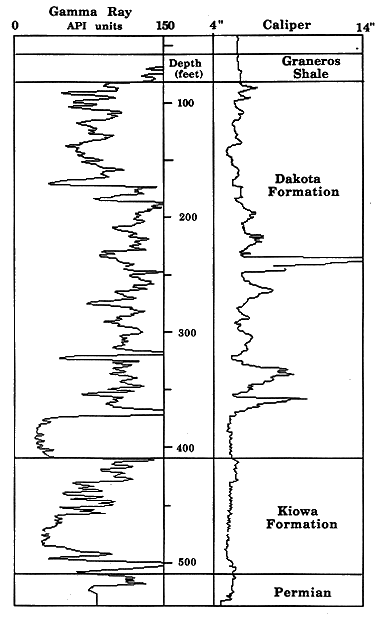
Figure 1.2 Gamma-ray and lithodensity logs of KGS Kenyon #1 S/2-SE-NE 24-4S-4W.
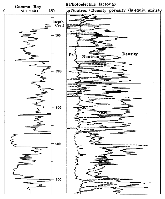
Figure 1.3 Spectral gamma-ray logs of KGS Kenyon #1 S/2-SE-NE 24-4S-4W.

Figure 1.4 Gamma-ray and resistivity logs of KGS Kenyon #1 S/2-SE-NE 24-4S-4W.
58-82 ft (18-25 m) (Graneros Shale interval)
The dominant lithology in this interval is dark-gray shale with
occasional calcareous, sandy laminations and abundant shell fragments.
The sand content decreases upward and the carbonate content increases
upward from the base of the interval. Hummocky cross-laminations are
common in the calcareous, sandy, fossiliferous zones in the lowest 10
ft (3 m) of this facies. There are two significant bentonites; one 10
in. (25 cm) thick at 74 ft (23 m) and the other 3 in. (8 cm) thick at
60 ft (18 m). On the gamma-ray log the bentonites can be recognized
from the increased levels of gamma-ray activity, and this shows up
particularly well on the thorium curve produced from the spectral gamma
ray detector.
This facies was deposited in the sea under generally quiet conditions
below fair weather wave base but above storm wave base. Storm action is
responsible for the hummocky cross-stratification. The decrease in sand
content and cross-stratification and the increase in calcium carbonate
content upward are due to decreasing influx of terrigenous material as
the shoreline moved eastward from this site. As a result, the
environment of deposition changed from shoreface to offshore marine with
less restricted circulation patterns (Hattin, 1975).
82-130 ft (25-39.6 m) (uppermost Dakota Formation)
The strata in this interval consist of interlaminated dark-gray mudstone and very fine to fine grained sandstone. The organic content is low to moderate and mainly in the form of carbon flecks, although occasional small plant fragments are also present. Many of the sand laminations are lenticular. These were formed by two separate processes: migration of starved ripples and soft sediment deformation resulting from shearing along bedding planes. Evidence of migration is ripple cross-laminations within the sand lenses. Convoluted and overturned laminae within the sand lenses are evidence of deformation. Burrowing and horizontal tracks are present below 98 ft (30 m). Individual coarsening-upward sequences are distinguishable in places, for example, in the top 9 ft (2.7 m) of this interval, which grades upward from a mudstone with occasional sand laminae to a calcite-cemented, rippled, fine-grained sandstone containing plant fragments. No shell fragments are found in or below this sandstone. This marks the boundary between the Graneros Shale above and the Dakota Formation below.
This sequence is a typical deposit of the distal bar of a prograding river-dominated delta (Coleman and Prior, 1988). Silt and mud settled out from suspension and variable river- or tide-related currents transported sand intermittently across the surface of the delta front forming laminations and ripples. Some soft sediment deformation occurred as a result of loading. Marine transgression overstepping the delta front prevented the deposition of a complete coarsening-upward delta sequence above this facies.
130-158 ft (39.6-48.2 m)
In this interval the grain size coarsens upward from laminated siltstone through laminated, very fine grained sandstone and siltstone with abundant carbon fragments along bedding planes to very fine to fine grained sandstone lacking sedimentary structures. The top of this sequence is capped by a lignite. The laminations vary from parallel and subhorizontal to wavy and rippled and include occasional climbing ripples. Burrows are present throughout this interval except within 6 ft (1.8 m) of the lignite. Roots penetrate 8 ft (2.4 m) into the underlying sandstone from the lignite.
The lignite at the top of this interval was deposited in a swampy subaerial environment suitable for dense plant growth and with little sediment influx. The underlying sands and silts were deposited in a subaqueous environment. The sedimentary structures are typical of a distributary mouth bar sequence. Such sequences, with a capping lignite formed in a swamp or marsh environment, commonly constitute the upper part of interdistributary bay fills in river-dominated deltas (Coleman and Prior, 1988).
158-172 ft (48.2-52.4 m)
In this part of the core there is a fining-upward sequence grading from poorly sorted fine-grained sandstone (with mud intraclasts just above the scoured base) to poorly sorted, muddy, very fine grained sandstone and interlaminated very fine grained sandstone and silty mudstone above 167 ft (50.9 m). Only half the fine sandstone was recovered in the core. Abundant organic debris in the form of carbon flecks and plant fragments is present throughout. Sedimentary structures consist of a few subhorizontal laminations throughout and occasional ripple cross-laminations in the upper 4 ft (1.2 m). The abundance of mica may be responsible for the general scarcity of ripples in the recovered sandstone. No large-scale bedforms are present.
The poor sorting and abundance of organic material are evidence of a relatively sudden drop in flow rate of the water transporting the sediment. The environment of deposition of this interval of the core is probably a partially abandoned distributary channel. The lower parts of such a channel are typically filled with poorly sorted sands and silts with an abundance of transported organic debris (Coleman and Prior, 1980).
172-186 ft (52.4-56.7 m)
Four vertically stacked, fining-upward sequences ranging from 1-6 ft (0.3-1.8 m), in thickness comprise the strata in this interval. The lower two sequences have a combined thickness of 2.5 ft (0.76 m) and consist of interlaminated very fine grained sandstone and siltstone. The upper two sequences have a combined thickness of 12 ft (3.7 m) and consist of light-gray massive siltstone grading up into light- and dark-gray mudstone with occasional green and red mottles.
This sequence of beds was deposited in a flood-plain environment. The laminated sandstone and siltstone in the lower 2.5 ft (0.76 m) was deposited on a levee by low-flow-regime currents during flood conditions.
186-310 ft (56.7-94.5 m)
Gray slickensided mudstone with red mottles and occasional green mottles and variable silt content comprises the bulk of this interval. Included are occasional darker gray beds and some coarsening-upward sequences of gray silty sandstone or sandy siltstone with evidence of plant colonization in the form of rootlet marks. These siltstones are not normally mottled. The finer grained zones show more red mottling than the coarser grained zones.
This facies was deposited from suspension during inundation of a flood plain by a river. The generally gray color of the sediment signifies reducing conditions, probably near or below a water table. Red mottles indicate deposition under more oxygenated conditions, possibly in topographically higher areas of the flood plain. Some mottles are in a rootlet pattern, showing that openings made by roots provided pathways for oxygen to enter the sediment.
310-324 ft (94.5-98.8 m)
This interval consists of orange medium-grained sandstone containing abundant wood chips that grade upward through orange and muddy gray fine-grained sandstone to very poorly sorted muddy, gray, carbon-rich, very fine grained sandstone to clean, green-mottled, very fine grained sandstone with rootlet marks. Recovery of the medium-grained sandstone during coring was poor, and its contract with underlying overbank deposits was not recovered. The only sedimentary structures are low-angle crossbedding in the orange fine-grained sandstone and faint parallel to wavy laminations in the muddy, very fine grained sandstone.
This sequence is the fill of a small channel that contained sufficient stream flow for the transport of medium-grained sandstone. The channel was then abandoned and filled with poorly sorted sediment under low-flow conditions. This was topped with levee deposits. Rootlet marks at the top reflect eventual colonization by plants. This is the highest level at which medium-grained sand was deposited. This deposit represents the last time that such high energy conditions existed during Dakota Formation deposition at this site. This was probably a function of the reduction in gradient to the sea during this period as sea level rose and the resulting reduction in competence of the streams.
324-368 ft (98.8-112 m)
This interval of the core consists mostly of gray slickensided mudstone with red mottles and occasional green mottles and variable silt content. The finer grained members of this interval contain more red mottling than the coarser grained members.
This facies was deposited from suspension during inundation of a flood plain by a river or rivers. The generally gray color of the sediment tells us that it was saturated with reduced water following deposition. Red mottles show that oxygenated water penetrated the sediment in places. Some mottles are in a rootlet pattern, showing that openings made by roots provided pathways for oxygen to enter the sediment.
368-410 ft (112-125 m)
Core recovery in this interval was generally poor. In the lower part of this interval medium-grained sandstone is present (a calcite-cemented sandstone occurs near the scoured base but otherwise the rock is crumbly) for approximately 24 ft (7.3 m) grading up into poorly indurated, fine-grained sandstone for approximately 12 ft (3.7 m). This grades up through interlaminated dark-gray silty mudstone and sandstone to dark-gray organic siltstone to structureless dark-gray organic mudstone with root marks at the top. The medium-grained sand of this interval contains planar rather than trough crossbeds, which show a preferred direction of dip. Higher up, convoluted, horizontal, wavy, and small-scale trough cross-laminations are common.
This interval is a classic fining-upward channel fill. High-flow-regime conditions existed during deposition of the crossbedded medium-grained sandstone. The decreases in grain size and in scale of bedforms upward reflect a reduction in flow rate associated with shoaling, as the main axis of the flow gradually moved away from the point of deposition. The scoured base of this river channel sequence marks the base of the Dakota Formation, which is an erosional surface cut into the marginal marine sediments of the Kiowa Formation below.
410-430 ft (125-131 m)
The strata in this interval consist of finely laminated, gray, very fine grained, micaceous sandstone and siltstone containing little clay. Occasional burrows and plant fragments are present. Flecks of carbon are common and are concentrated in thin discontinuous laminae that are distributed throughout. The laminations are generally parallel apart from some wavy and lenticular laminations in a 2-ft-thick (0.6-m-thick) coarsening-upward zone close to the top of this interval. The lack of ripple laminations may be due to the high mica content, which has an inhibiting effect on ripple formation.
Laminations are inclined at approximately 20° (above 424 ft (129 m). Laminations between 424 ft (129 m) and 426 ft (130 m) are convoluted and slumped. The consistent dip of the laminations above this zone is probably a result of rotational slumping, which is often found in delta-front environments. The laminations were probably originally subhorizontal.
The limited burrowing, general lack of mud, and high carbon and mica content are evidence of a marginal marine environment consistently under the influence of low-energy currents. The plant debris is a consequence of the sediment being directly supplied from local distributaries. The environment of deposition of this facies is probably the upper distal bar of a delta.
430-457 ft (131-139 m)
This interal consists of two interbedded facies: (1) a gray, laminated, sometimes deformed or burrowed, muddy, very fine grained sandstone similar to that described in the above interval and (2) a ripple laminated, micaceous, fine- to medium- grained sandstone that is commonly cemented with iron and also contains some calcite cement in small quantities. Beds of facies 2 include occasional rip-up clasts near the base. Beds of facies 1 are 0.5-5 ft thick (0.2-1.5 m. thick) are interbedded with up to 1.5 ft (0.46 m) of facies 2. The thickness of facies 2 beds generally increases with decreasing grain size from fine-medium to fine grained, whereas the thickness of beds of facies 1 generally decreases upward. This suggests that the processes responsible for deposition of 2 became more common and longer lasting but weaker with time. There is evidence of more than one direction of ripple migration in the form of crossing of adjacent sets of ripple laminae but no evidence of symmetric ripples or form-discordant or chevron internal structure; that is, there is no evidence that wave action was responsible for deposition of this facies.
This sequence is a typical deposit of the upper distal bar of a prograding river dominated delta (Coleman and Prior, 1988). Very fine grained sand, silt, and mud settled out from suspension and variable river-flood or tide-related currents transported sand intermittently across the surface of the delta-front depositing facies 2. Some soft sediment deformation occurred because of loading. A rise in relative sea level or a shift in the axis of deposition of the local distributary terminated deposition of facies 2 at 430 ft (131 m).
457-500 ft (139-152 m)
This interval consists mainly of medium-grained, crossbedded, and ripple laminated gray sandstone that is generally poorly cemented but contains patchy red iron oxide and calcite cements. There is an overall fining upward of the sandstone above 487 ft (148 m) from medium to fine grained. However, below 487 ft (148 m), the sandstone coarsens upward from the scoured base with abundant gray siltstone intraclasts and plant fragments in the fine-grained sandstone immediately above the scour. This basal intraclast-rich sandstone is predominantly red. It is interbedded with gray, micaceous, laminated and convoluted siltstone and very fine grained sandstone up to 487 ft (148 m). The almost continuous crossbedded sandstone of the upper 30 ft (9 m) of this interval is interrupted only by occasional mud drapes and carbonaceous lenses up to 1 in. (2.5 cm) thick.
This sequence is generally coarse grained, with an erosive base, and contains major bedforms, which is typical of the fill of an active channel. However, it has features that are not typical of a fluvial channel; in the lowest 13 ft (4 m) it coarsens upward and includes beds of relatively fine-grained, laminated silt and sand reflecting periods of lower energy. Large-scale bedforms do not become prevalent until higher in the sequence, where they are occasionally draped with mud deposited during intervals of low energy. This considerable variation in current intensity is good evidence that this interval is a tidal rather than a fluvial channel deposit.
500-507 ft (152-155 m)
This interval consists of interlaminated, very fine grained sandstone and mudstone that is severely deformed in the upper 2 ft (0.6 m). Occasional ripple and lenticular laminations and carbon flecks are present and pyrite nodules are fairly common. This interval was deposited in a subaqueous environment with intermittent currents strong enough to form ripples in very fine grained sand, such as in a tide-influenced distal bar or estuarine environment.
507-512 ft (155-156 m)
This part of the core consists of a hard, gray, slightly calcareous, faintly laminated mudstone with occasional shell fragments overlain by 2 ft (0.6 m) of brecciated, laminated, silty, very fine grained sandstone with rootlet marks at the top. The top of the Permian Wellington Formation is at 510 ft (155 m). The hard shelly shale below the top of the Permian was deposited in a marine environment. The rooted sandstone is associated with a period of subaerial deposition following erosion of the Permian sediments. Brecciation of the sandstone may have been caused by dissolution of evaporite deposits, which are common in the Wellington Formation.
Start of this report || Table of Contents