Kansas Geological Survey, Open-File Rept. 90-27
Annual Report, FY89--Page 2 of 10
The Dakota aquifer system is an integral part of the water-resources planning effort for western and central Kansas. The Dakota aquifer framework consists of the Dakota Formation, Kiowa Formation and Cheyenne Sandstone in Kansas. It is the second most geographically extensive aquifer system in Kansas after the High Plains aquifer (Ogallala and associated alluvial aquifers). In the near future, localized depletion of the High Plains aquifer in western areas and depletion of water supplies in stream-aquifer systems in the central part of the state due to overdevelopment, will cause critical water shortages. A lack of water will certainly affect the future economic well-being of central and western Kansas. In these areas the Dakota aquifer may be the next best available source of water. At present, however, insufficient information on the quantity and quality of Dakota waters limits the abilities of State water-planning and regulatory agencies to evaluate this aquifer as a future source of water for central and western Kansas. Equally important, the effects of development on water availability and quality are also largely speculative due to lack of information on the nature of the regional ground-water flow system and the properties and sedimentary architecture of the Dakota aquifer framework.
In response to a request from the Interagency Water Steering Committee, the Kansas Geological Survey prepared a program proposal in 1988 to assess the water-resources potential of the Dakota aquifer in Kansas. The program outlined in the proposal was for a long-term, multi-phase, multi-agency research effort. As part of the proposal, the first-year program goal was to develop a research plan to fulfill the needs of state and local water-planning and regulatory agencies. The research plan was to be formulated on the basis of (1) an initial characterization of the hydrogeology and hydrogeochemistry of the aquifer and patterns of use, and (2) an evaluation of the methods and concepts used in previous investigations of the Dakota aquifer. The Kansas Geological Survey began work on the first year of the program in FY 89. In addition to the above objectives, the concerns of the various state and local water-planning and regulatory agencies, including the ground-water management districts, were actively solicited and used to define the course of future research efforts in the Dakota aquifer program in succeeding years. Additionally, concerns on the Federal level for energy conservation through improved well siting in the Dakota aquifer prompted a study of energy-use patterns in irrigation systems using water from the Dakota aquifer.
Acting on these objectives Kansas Geological Survey (1) has begun development of geophysical, geologic, hydrologic, water quality and water-use data bases for the Dakota and hydraulically connected aquifer systems; (2) examined the regional hydrogeology and geochemistry of ground waters in the Dakota and hydraulically connected aquifers; (3) defined the regional stratigraphic framework of the geologic units that are represented in the Dakota aquifer; (4) conducted research and development on new geologic and geophysical techniques for gathering information in areas of sparse data coverage; and (5) assembled a plan of research based on a regional conceptualization of the Dakota aquifer in Kansas.
The purpose of this report is three-fold: (1) briefly review the status of research on the Dakota aquifer, (2) present the regional hydrogeologic and hydrogeochemical setting of the Dakota aquifer and patterns of present use, and (3) outline the future plan of research on the Dakota aquifer based on research needs perceived by the Kansas Geological Survey and the State water-planning and regulatory agencies. The presentation of the regional hydrogeologic and hydrogeochemical setting included a description of the Dakota aquifer framework using sequence stratigraphy and geophysical well-log analysis techniques and the results of a field study to assess the feasibility of using shallow seismic methods to locate sandstone lenses and structures in the subsurface.
For the most part, this report discusses the salient features of the Dakota aquifer in broad regional terms, dealing with details only to the extent that they illustrate specific points. Additional detail will be developed in the subregional studies. It is also important to bear in mind that this is a report of work conducted in scientific disciplines that are extremely diverse and that yield results at different rates. As a result, this is not a "finished product" in the sense that the results are well-integrated and equally uniform in detail. The report is more of the status of the research effort and is meant to describe progress and any significant results in the research program as of the end of the first year.
Figure 2.1. Geographic extent of the Dakota aquifer in Kansas.
Upper and lower Permian Series strata in the shallower part of the subsurface consist of (1) red bed-evaporite sequences deposited in a nonmarine-marine environment under hot, arid conditions and (2) sandstones of the Cedar Hills Sandstone subareally deposited by eolian processes and subsequently salt-cemented by evaporation of shallow ground waters (Swineford, 1955; Holdoway, 1978). Pre-Cretaceous subaerial exposure has probably removed by dissolution much of the salt cement from the Cedar Hills Sandstone in central and western Kansas. The formation is locally salt-cemented in the Permian Syracuse basin (western part of the Cretaceous Western Kansas basin) and in parts of south-central Kansas. Beds of anhydrite are present at the top of the Cedar Hills Sandstone nearer the Denver basin in northern and extreme western Kansas near the Colorado border. The red-bed evaporite sequence consists of interbedded shales, siltstones, fine-grained sandstones, evaporites, and bedded evaporites consisting of halite and anhydrite. Plates 9, 10, and 11 show the altitude of the Permian top, the altitude of the Cedar Hills Sandstone, and the thickness of the Cedar Hills Sandstone in Kansas, respectively.
Jurassic strata belonging to the Morrison Formation rest unconformably on the Permian in the northwest half of western Kansas. In southwest Kansas, near the Kansas-Colorado border, the Morrison consists of interbedded fine-grained sandstones and mudstones of fluvial and lacustrine origin. Elsewhere the interbedded shales, siltstones, freshwater limestones and evaporites are a common occurrence in the Morrison. Plates 7 and 8 show the altitude of the Morrison Formation top and thickness of the Morrison Formation in Kansas, respectively.
Cretaceous strata rest unconformably on the Jurassic and Permian units and belong to the Upper and Lower Cretaceous Series. In southwest and central Kansas and eastern Colorado, transgressive and regressive shales and siltstones and interbedded chalky shales and thin limestones associated with the Greenhorn cycle of deposition are represented in Upper Cretaceous strata (Hattin and Siemers, 1987). Fluvial to paralic to shallow offshore sequences of interbedded sandstone and mudstone in the Dakota Formation, Kiowa Formation and Cheyenne Sandstone are represented in the Lower Cretaceous Series (Hamilton, 1989).
Above the Cretaceous and Permian bedrock surface, the study area is mantled by varying thicknesses of unconsolidated Quaternary and Miocene-Pliocene deposits (Ogallala Formation). These consist of unconsolidated fluvial, lacustrine, and eolian sediments derived from episodic erosion of the Rocky Mountains in eastern Colorado during the latter part of the Tertiary and the High Plains and Rocky Mountains during the late Pliocene and Quaternary (Frye and Leonard, 1952; Frye et al., 1956; and Gustavson and Winkler, 1988). These deposits fill paleovalleys cut into older unconsolidated deposits and bedrock by eastward-flowing streams during the early part of the Tertiary.
Cretaceous strata in the western United States were deposited in the Western Interior Cretaceous basin of North America. Kansas strata were deposited on the eastern side of the basin. Basin subsidence farther west in the present Rocky Mountain states was initiated around 115 million years ago (Ma) (Jordan, 1981). The basin was subsequently segmented into present-day intermontane basins of the Rocky Mountain region approximately 65 Ma (Weimer, 1984; Dickinson, et al. 1988). The Denver basin is one of these basins (Figure 2.2).
Figure 2.2. Regional geologic structures in western and central Kansas and adjoining areas of Colorado, Nebraska, and Oklahoma.
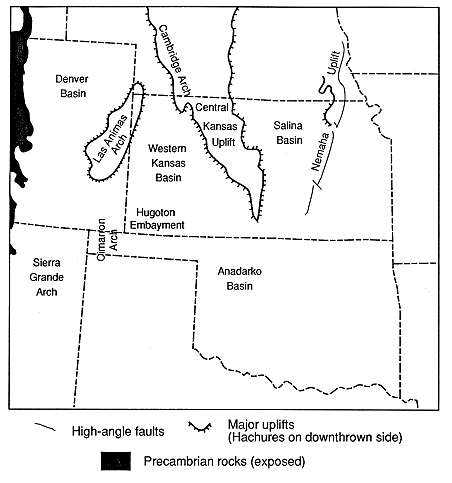
The Central Kansas uplift was a positive structural and topographic feature during the Paleozoic (Merriam, 1963). The Las Animas arch was a positive feature which affected sedimentation during Paleozoic time (Rascoe, 1978). Merriam (1963) suggested that the Central Kansas uplift and the Las Animas arch were positive topographic elements during the Mesozoic. The Las Animas arch along with the Cimarron arch and the Hugoton embayment of the Anadarko basin may have been tectonically active or positive topographic features during the Cretaceous.
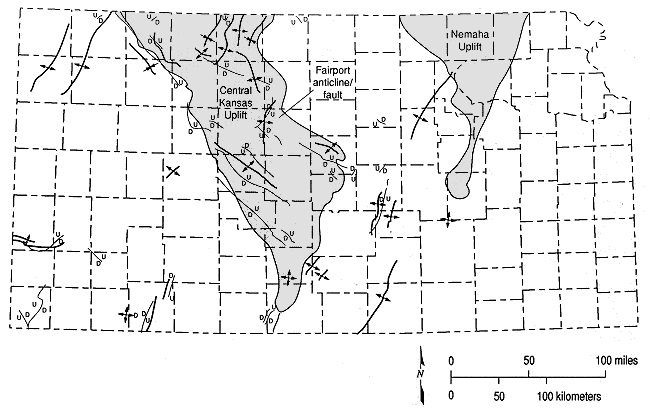
Numerous faults and folds are present across Kansas (Figure 2.3). Berendsen and Blair (1986) studied some of these in central Kansas and concluded that recurrent movement occurred along Precambrian fractures throughout Paleozoic time. It is likely then that movement continued on these and other structures during Mesozoic time.
Figure 2.3. Occurrence of faulting in Kansas (adapted from Merriam, 1963).
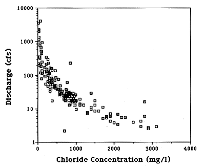
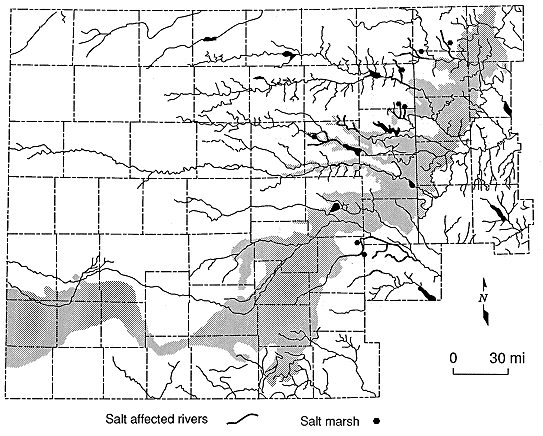
Salt marshes and springs are common in the river valley areas in many parts of central Kansas (Hay, 1890, 1891; Jordan et al., 1964; Whittemore, 1978; Hargadine et al., 1979; and Cobb, 1980) (Figure 2.4). In the Saline, Solomon, and Republican River valleys, these hydrologic features occur near the top of the Dakota Formation. Salt-affected reaches of streams are also common in this area where the valleys are underlain by Lower Cretaceous and Permian strata. Many of the streams that drain this area discharge waters higher in total-dissolved solids (TDS), chloride and sulfate concentrations under low-flow conditions than in other parts of the state.
Figure 2.4. Distribution of salt marshes, salt springs, and salt-affected reaches of streams associated with or adjacent to the Dakota aquifer outcrop belt in Kansas.
The Bear Creek-Crooked Creek-Fowler faults and many closed structural lows in the bedrock surface beneath Cenozoic deposits have resulted from the dissolution of salt in the Permian red beds (Frye, 1950, Merriam, 1963) of western and central Kansas. Some solution-collapse features resulting from improperly plugged or unplugged boreholes are also present in several areas of central Kansas (Walters, 1977).
Figure 2.5. Stream discharge vs. chloride concentration of surface waters in the Saline River north of Russell, Kansas.