


Kansas Geological Survey, Open-file Report 88-39
Great Plains and Cedar Hills Aquifers--Page 9 of 25
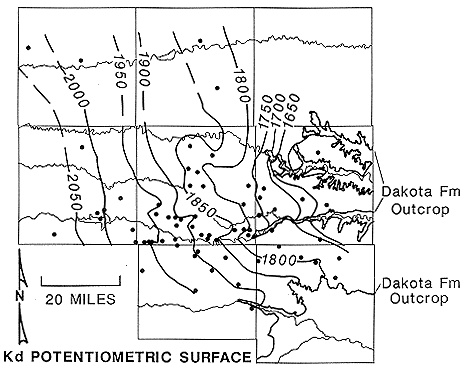
Figure 17. Potentiometric surface of the upper portion Great Plains aquifer.
A similar pattern can also be seen for the lower part of Great Plains aquifer system (Cheyenne) shown in Figure 18. The contours for this map are generalized due to lack of data. Some of the data points used to construct this map are from studies completed in the 1970's (Bryson, 1970's).
Figure 18. Potentiometric surface of the lower portion Great Plains aquifer.
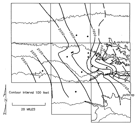
Within the study area, the potentiometric surface of the lower part of the Great Plains aquifer is higher in elevation than the potentiometric surface of the upper part over most of the study area. Hydraulic head differences between the upper and lower portions of the Great Plains aquifer are as much as 100 feet locally. More typically, these differences are on the order of 50 feet over the area. This indicates an upward flow component from deeper to shallower zones within the Great Plains aquifer system over virtually the entire study area with the exception of the Gorham area in western Russell County. At the Gorham monitoring site, the hydraulic head difference between the upper and lower portions of the aquifer is approximately 25 feet. In this area the movement of ground water is from the upper part of the aquifer to the lower part.
Recharge to the Great Plains aquifer system comes from precipitation falling on the northeast-trending outcrop belt, underflow from the Western Kansas basin, interaction with the Cedar Hills aquifer, and as leakage through the Great Plains Confining System from near-surface aquifers. Helgeson et al. (in review) estimated that the long-term average recharge rate to the Great Plains aquifer is on the order of 10 ft3/sec. in the central Kansas outcrop areas of the Dakota and Kiowa Formations. These authors could not quantify leakage through the overlying Great Plains Confining System or recharge from the underlying Cedar Hills aquifer in central Kansas directly due to lack of sufficient data. However, from a regional steady-state ground water flow model of the Great Plains aquifer, they estimated that leakage from overlying units to the aquifer is 296 ft3/sec. The Cedar Hills aquifer is vertically adjacent and in hydraulic connection with the Great Plains aquifer east of R19W in the study area. Underflow into the study area is estimated to be on the order of 36 ft3/sec. along the western and southern boundaries of the area assuming an average horizontal hydraulic conductivity of 10 ft/day for the Great Plains aquifer.
Discharge from the Great Plains aquifer is to streams and wells in the study area and to areas adjacent to the study area as underflow. The total pumpage from municipal, domestic, and stock use is estimated to be 0.14 ft3/sec. (100 acre-ft/year). The average discharge rate to streams has been estimated by Helgeson et al. (in review) to be between 46 and 60 ft3/sec. for streams in central Kansas. Assuming a horizontal hydraulic conductivity of 10 ft/day, discharge to the Saline and Smoky Hill Rivers from the Great Plains aquifer in Russell County is estimated to be 0.3 ft3/sec. per mile of river valley (19 ft3/sec for both river valleys). No estimates of underflow to areas adjacent to the study area have been made.
The effects of pumping on the potentiometric surface of the upper part of the Great Plains aquifer system can seen in southern Ellis County near the Smoky Hill River and in the area north of Hays in Ellis County. In both areas many domestic and stock wells withdraw water from this part of the Great Plains aquifer.
Previous page--Regional Aquifers ||
Next page--Cedar Hills Flow
Start of Report ||
Report Contents