


Kansas Geological Survey, Open-file Report 88-39
Great Plains and Cedar Hills Aquifers--Page 2 of 25
1.0 Introduction
1.1 Purpose of This Report
The Great Plains aquifer system is a vast, largely untapped resource that
underlies much of western Kansas. The framework of this aquifer system
consists of the Dakota Formation, The Kiowa Formation and Cheyenne
Sandstone. Little is known of the hydrogeology and water quality of
this aquifer system in Kansas, especially the relationship of the Great
Plains aquifer system to other interconnecting aquifers. Recently, the
Kansas Corporation Commission has become concerned that disposal of
oil-field brines into the Cedar Hills Sandstone may be inducing upward
migration of saline waters and disposed oil-field brines into usable
shallow aquifers containing fresh and usable waters. This injection
horizon occurs just below the Great Plains aquifer system in much of the
area.
To address these concerns, the Kansas Geological Survey initiated a
study of the Great Plains and Cedar Hills aquifer systems in an eight
county area of central Kansas. This investigation was conducted to
determine the hydrogeology and water quality of these aquifers and to
identify areas of upward migration of naturally occurring and oil-field
brines from the Cedar Hills Sandstone into the shallower freshwater
aquifers. In order to accomplish these objectives:
- the results of previous geologic and hydrogeologic investigations of
the Great Plains and Cedar Hills aquifers were collected and analyzed to
obtain stratigraphic, hydrogeologic and hydrochemical information;
- maps were prepared to show the top configuration and thickness of
geologic units in the study area based on the examination of geophysical
well logs, well cuttings and outcrops;
- several multiple completion monitoring wells were constructed to
obtain water chemistry and hydrologic information vertically across the
Great Plains and Cedar Hills aquifers; and
- water level data and water samples were collected from wells,
springs, and surface waters to define the present-day water flow and
determine the origin of chemical constituents of waters in the Great
Plains and Cedar Hills aquifers in the study area.
This report is a summary of the results of that investigation and
presents some preliminary conclusions concerning the hydrogeology and
water chemistry of these very complex aquifers in the eight county area.
The conclusions drawn from this investigation should be considered
preliminary. Several unanswered questions remain to be explored. These
are listed under Future Research Needs (11.0). It is important to note
that many of these questions are fundamental to our understanding of the
movement of waters in these rocks and bear significantly on questions of
water quality and interconnection between the Cedar Hills and Great
Plains aquifers.
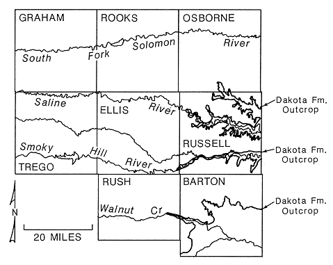
1.2 Geographic Extent of the Study Area
The study area is located in the Smoky Hills and the High Plains
physiographic provinces in central Kansas and covers all or parts of
Russell, Ellis, Barton, Rush, Rooks, Osborne, Graham, and Trego counties
(Figure 1). Included within the study area are portions of the Smoky
Hill, Saline, Solomon, Wet Walnut, and Arkansas River drainage basins.
The largest population centers in the study area are Hays and Russell
located in Ellis and Russell counties, respectively.
Figure 1. Location and extent of the study area
1.3 Acknowledgements
The authors wish to express their appreciation to the following agencies
and individuals who helped to make this report possible. Our
appreciation is given to the Kansas Corporation Commission, especially
the District 6 office in Hays, and the Interagency Dakota Technical
Committee who provided us with guidance and data. Appreciation is also
given to Bill Bryson and Don Butcher who helped us over rough spots in
the work and provided much-needed moral support. Within KGS many
individuals contributed their expertise and talent to the collection of
data in the field and laboratory, and the assembly of this document.
The authors wish to acknowledge Larry Hathaway, Karmie Galle, and Bud
Waugh of the Analytical Services Section, Joe Anderson of Exploration
Services, Renate Hensiek of Graphic Arts and Anna Corcoran of the
Geohydrology Section. Finally, a debt of gratitude is owed our
administration who helped smooth some of the bureaucratic wrinkles that
developed between agencies and kept the project afloat.
Previous page--Abstract ||
Next page--Previous Research
Start of Report ||
Report Contents
Kansas Geological Survey, Dakota Project
Original document dated December, 1988
Electronic version placed online April 1996
Comments to webadmin@kgs.ku.edu
URL=http://www.kgs.ku.edu/Dakota/vol3/KCC/kcc02.htm