


Dakota Aquifer Program--Petrophysics
Geophysical Log Analysis of the Dakota Aquifer
Introduction
Geophysical logs are records of physical properties of rocks in
boreholes drilled for hydrocarbons, minerals or water. They are
made by electrical, acoustic and nuclear tools suspended on a
wireline and winched upwards through the formations penetrated by
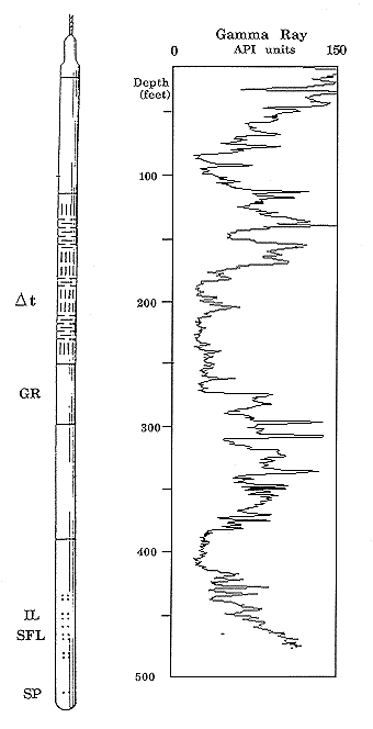
the borehole (Figure 1). A logging tool may be about fifty feet in
length and its measurements are recorded as traces on a graphic
chart of depth, known as a "log". Most tools are run by logging
service companies for the oil industry in both exploration holes and
producing wells. Fortunately, many of the rock properties that are
used to locate and describe oil and gas reservoirs are also useful in
the search for aquifer beds with usable water.
Figure 1. Combination logging tool for measuring acoustic
travel time (delta t), natural gamma radiation (GR), shallow-focussed (SFL)
and deep-focussed electrical conductivity (IL), and spontaneous electrical
potential (SP) of rock formations in a borehole, together with a typical
gamma-ray log of a Dakota Aquifer section. The tool shown is 55 feet 7
inches long.
The long history of oil exploration in Kansas has resulted in the
recording of hundreds of thousands of logs across the state. These are
filed with the Kansas Corporation Commission and then archived at
both the Kansas Geological Survey in Lawrence and the Kansas
Geological Society in Wichita, where copies are available for purchase
by the public. The main use of logs is for the identification of the depths
of stratigraphic formation boundaries ("tops") and their
correlation between wells. The maps of correlated tops are similar in
style to topographic maps. However, a map of an underground
surface cannot be seen, but must be estimated in between the
available well control.
In addition, logs also provide valuable information on the Dakota Aquifer
because they can be used for:
- (1) rock type recognition
- Sandstones (aquifers) can usually be distinguished easily from
shales (aquitards) in the Dakota on most logs. This information can
be used to give both depth and footage of sandstones at the well
location, as well as for tracing them between wells.
- (2) sandstone storage capacity determination
- Some logging tools (the density, neutron, and acoustic velocity or
sonic) make measurements that can be used to calculate the
volumetric proportion of the sandstone that is water.
- (3) water quality estimation
- The electrical logging measurements of spontaneous potential
(SP) and resistivity can be used to estimate the salinity of water
within Dakota sandstones.
These three applications are explored in more detail in the following
pages, where the properties and uses of the common logs are
described. All the logs illustrated have been taken from a single
well, so that the properties and interrelationships can be understood
more easily.
Previous page--Petrophysics Intro Page ||
Next page--Gamma-ray Log
Dakota Home
Kansas Geological Survey, Dakota Aquifer Program
Updated July 5, 1996
Scientific comments to P. Allen Macfarlane
Web comments to webadmin@kgs.ku.edu
URL=http://www.kgs.ku.edu/Dakota/vol1/petro/petro02.htm