Additional development of water resources in the Dakota aquifer will be determined largely by the needs of users, the availability of water from the Dakota and other aquifers, and the management goals and the planning horizons established by state and local water planning and regulatory agencies in Kansas. Management options, including issues related to long-term sustainability, are discussed more fully in the Sustainability of the Dakota Aquifer section of this report.
In general, the closer to the northwest corner of Kansas a potential well site is located , the greater the depth to the top of the Dakota aquifer. This makes well construction and pumping more expensive depending on the needs of the user. Where the depth to the top of the confined aquifer approaches 1,000 ft or more, the depth to water from land surface approaches 300 to 350 ft. Uses that are more water intensive, such as irrigated agriculture, are not practical because of the high energy costs associated with production relative to well yield. As a result, the Dakota is currently an underutilized resource in most of western Kansas because of the availability of shallower, more prolific supplies in the High Plains aquifer. However, as these supplies continue to become scarcer and more valuable, exploration for usable waters in the confined aquifer will increase for other uses, such as public water supply, stock watering, and domestic purposes. The salinity of Dakota aquifer waters is one of the most important factors limiting current exploration in the confined aquifer. Water availability and economics have caused the City of Hays to develop slightly saline waters in the Dakota in west-central Ellis County. For a short time, Hays also experimented with advanced treatment technologies to reduce the level of salinity in the water coming from its new well field.
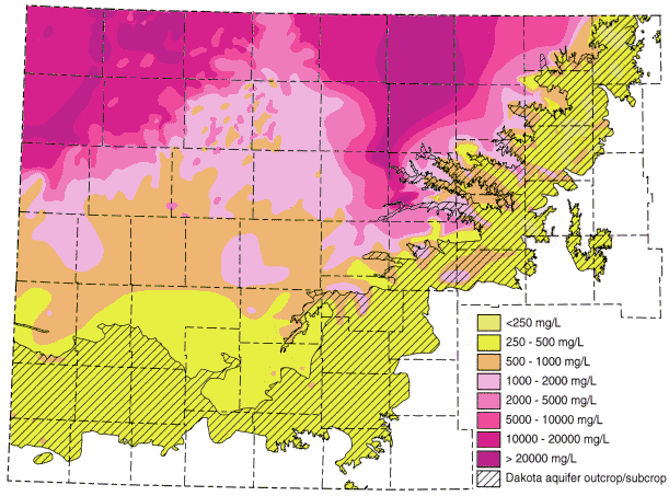
The Dakota Aquifer Program has discovered a substantial area of additional waters that are nearly fresh to slightly saline that could be important for future supplies. The aquifer area is roughly shaped as a triangle with its base along the south lines of Sheridan and Graham counties and extending into south-central Norton County (Figure 1). Most of this area was previously believed to have waters of substantially greater salinity. Regional flow of fresher ground water through the Dakota aquifer from the southwest is believed to have flushed salinity to the present levels. Some waters may even be slightly less than the TDS classification for fresh (less than 1,000) in thick and wide sandstones in the south-central portion of this triangle where greater permeability could have allowed more extensive flushing. Parts of western Gove County may also have more freshwater than earlier thought.
Figure 1. Distribution of total dissolved solids (TDS) concentrations in ground waters in the upper Dakota aquifer in western and central Kansas. Water less than 1000 mg/L TDS is defined as fresh. Water with 1000-2000 mg/L TDS is usable for many purposes but is less desirable than fresh water. A concentration of 10,000 mg/L is defined in the state regulations of the Kansas Corporation Commission as the upper limit of usable water; above 10,000 mg/L a water is classified as unusable or mineralized.
Partially developed areas where additional withdrawals could occur are mainly underneath greater saturated thicknesses of the High Plains aquifer in southwest Kansas, and the portions of the aquifer not currently greatly stressed in the eastern outcrop/subcrop area and the zone of the confined aquifer nearest the outcrop/subcrop belt. In the confined aquifer the sandstones in the upper Dakota aquifer will be the primary targets for new exploration because of their greater thickness and permeability and lower levels of salinity. In southwest Kansas, the primary targets for exploration will be the sandstones in both the upper and lower Dakota aquifers and in the underlying Morrison. In the outcrop areas of central Kansas, the sandstones in the upper Dakota and near the eastern margin, in the lower Dakota will be likely targets of exploration for new water supplies.
Previous Page--Well Spacing Requirements
Dakota Home ||
Start of Report