This variability strongly indicates that management of water resources in the Dakota aquifer is best undertaken at the subregional level. Within each subregional management area, the hydrogeologic and water-quality characteristics are similar within a certain range of possible states and parameter values. Each management area has its own set of factors to consider in developing appropriate policies and plans for development. Hence, the constraints on water-resources development will vary from one management area of the aquifer to another. A similar basis was used to define distinct subregions of the High Plains aquifer and the boundaries of the groundwater management districts. However, for the Dakota, it is not appropriate to establish groundwater management districts because the boundary locations between management areas are not well known and may change. The rate and intensity of development is an important factor which may necessitate the adjustment of these boundaries. We have partially addressed these factors by arbitrarily selected a 20 yr planning horizon. More importantly, the Dakota remains a relatively unknown aquifer system in Kansas in comparison to the High Plains aquifer. It is expected that as development of the Dakota proceeds, the boundaries defining these management areas will be refined as more information becomes available.
The following is a description of the proposed management areas that we believe adequately capture the variable nature of the Dakota aquifer in Kansas. Figure 1 shows the approximate extent of each of the management areas. These management areas are defined primarily on the basis of their hydrogeologic and secondarily on their water quality characteristics. The dashed line represents the 1,500 mg/L total dissolved solids isocon.
Figure 1. Proposed management areas of the Dakota aquifer in Kansas. The boundaries of these areas are defined by their hydrogeologic and water-quality characteristics. The dashed line represents the 1,500 mg/L dissolved solids isocon in the Dakota aquifer.
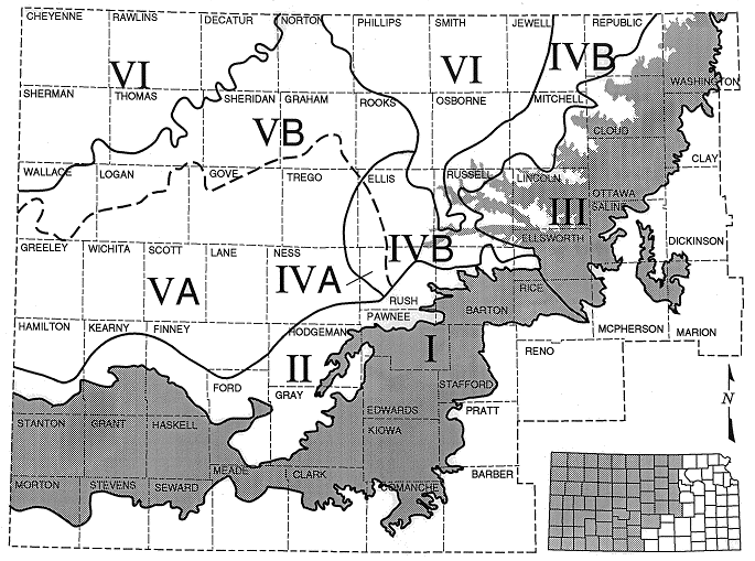
Management Area I: The Dakota and High Plains aquifers are in hydraulic connection and both aquifers should be managed as a single system. Ground waters in the Dakota are fresh. However, poorer quality waters may be present locally in the eastern part of the management area at depth. The major local influences on flow patterns in the Dakota are the hydraulic head gradients between the aquifers and vertical leakage.
Many of the high-yielding wells in the upper and lower Dakota are located in this management area. At the present rate of development, a well-spacing of 0.5 miles is most appropriate since the Dakota is not as prolific an aquifer as the overlying High Plains aquifer. More stringent spacing coupled with regulated rates of withdrawal may be required locally as more wells tap into the aquifer.
Management Area II: The Dakota aquifer is confined by the Upper Cretaceous aquitard near the edge of the outcrop/subcrop belt. Ground-water flow is generally from the outcrop/subcrop belt into the confined region of the aquifer. Ground water in the Dakota is generally fresh. Wells located in this part of the aquifer are likely to induce additional flow into the aquifer from unconfined areas within a 20 year planning horizon. Water in the lower part of the Dakota aquifer in the central and eastern parts of the management area could be saline.
Many of the high-yielding wells in the upper Dakota are also located in this management area. The most important water-resources issue is induced recharge from the overappropriated High Plains aquifer and some of the alluvial aquifers caused by ground-water withdrawals from the confined Dakota aquifer. Additional development in this part of the aquifer will gradually accelerate the water loss from storage in the shallow aquifers and will have a minor impact on streamflows. Looking only at the water resources in the Dakota aquifer, the 4 mi well spacing appears to be appropriate. Additional controls, such as increased well spacing and regulation of withdrawal rates, may be needed in the future if the pace of development increases.
Management Area III: Confined and unconfined regions of the aquifer are strongly influenced by local flow systems. Where present, the Upper Cretaceous aquitard is thin and more permeable than in areas to the northwest. As a result vertical freshwater recharge across the aquitard is higher and significant flushing of salinity in the upper Dakota aquifer has occurred. However, recharge rates are still very low in comparison to practical rates of withdrawal for large capacity wells. Flow path lengths are generally shorter between local recharge and discharge areas and aquifer diffusivity is higher. Thus, induced recharge from local recharge and discharge areas is likely. Recharge rates are on the order of a few tenths of an inch per year in the outcrop region. Water quality in this management area is locally variable and is generally saline in the lower parts of the confined aquifer in this management area.
Current rates of development are low but there are local concentrations of high-yielding wells in the upper Dakota aquifer. The long-term hydrographs of observation wells in the outcrop region indicate that this development has not induced any long-term hydraulic head declines. One modeling study in the management area suggests that the major impact of development seems to be a reduction of discharge to streams within this management area. Where the Upper Cretaceous aquitard is present, development in this part of the area may induce recharge from the outcrop region. As a result, the 0.5 miles well spacing for the outcrop belt and the 4 mile spacing for the confined region seem to be most appropriate at the present time.
Management Area IV: Areas IVA and B are located in the confined aquifer near the Dakota and underlying Permian regional discharge areas. The Kiowa shale aquitard and the underlying Permian aquitard units are not present in most of the area. Saltwater intrusion in the upper Dakota from sources in the lower part of the Dakota and underlying Cedar Hills Sandstone aquifer is widespread. Limited recharge across the Upper Cretaceous aquitard has flushed some of the salinity from the most permeable zones in the uppermost Dakota aquifer. Ground-water salinity generally increases with depth.
Water quality in area IVA is acceptable for most uses. Water quality in area IVB is marginally usable but would require additional treatment to remove dissolved solids for most uses. Pumping centers need to be spaced far apart and pumping rates monitored closely so as not to diminish regional discharge from the Dakota or induce additional saltwater intrusion from lower Dakota aquifer.
Management Area V: In areas VA and VB the confined Dakota aquifer receives nearly negligible recharge from overlying sources. This part of the Dakota aquifer is also far enough away from the outcrop/subcrop belt and regional recharge areas in southeastern Colorado that pumping will not induce significant recharge during the 20 yr planning horizon. Depths to the top of the Dakota are generally less than 1,000 feet in area VA and 1,500 ft in area VB.
The density of development in this region is currently very low. The spacing between pumping centers that withdraw water at higher rates is greater than 20 miles. Well spacing should be the greatest in this management area to minimize the likelihood of water-rights impairment. Modeling studies in this management area suggest that a well spacing of 20 mi, coupled with restrictions on rates of withdrawal, are appropriate to minimize the possibility of impairment. In area VA, the water quality is acceptable for most uses. In area VB ground water in the Dakota is marginally usable but would require some level of advanced treatment to remove dissolved solids. In general, the farther to the north and east in these areas, the greater the increase in salinity with depth.
Management Area VI: Defined as the unusable portion of the aquifer. Ground waters in this part of the aquifer contain total dissolved solids concentrations in excess of 10,000 mg/L.
Previous Page--Sustainability of the Dakota Aquifer ||
Next Page--Well Spacing Requirements
Dakota Home ||
Start of Report