Hodgeman County Study, part 7 of 12
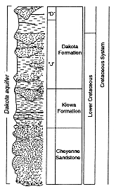
Figure 3. Generalized stratigraphic column for the Dakota aquifer in Kansas (After Macfarlane and Sawin, 1995).
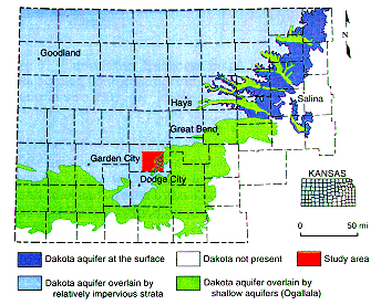
The sampling in the appendix is a first attempt to overcome lack of data at least at the county scale. Data in the appendix is a by-product of well logging by the petroleum industry exploiting fields beneath the aquifer. As shown in Figure 4, the study area is a 3 by 3 township square in south central Hodgeman county.
Figure 4. The Dakota aquifer in Kansas showing location of the study area (After Macfarlane and Sawin, 1995).
Experimentation showed us that the Dakota Formation is too thick a unit for the purpose of characterizing its heterogeneity. In addition the uppermost part of the formation is missing due to fluvial erosion in the eastern side of the study area. Following the practice in neighboring Colorado, we divided the formation into the upper "D" and the lower "J" sandstones, discarding the partly missing "D" and subdividing the thicker "J" sandstone into the basal 120 ft and the remainder of the deposits above. When present, the "D" sandstone in the area ranges from 20-90 ft. 331 gamma ray logs were digitized and entered into a data base that was then accessed by a computer program.
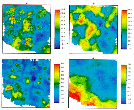
Combined laboratory and field work has demonstrated that groundwater flow occurs at those levels where the natural gamma ray radiation in cased wells is below 60 API units (P. A. Macfarlane, 1995, personal communication). Hence we considered as sandstone any sediment below that radiation threshold in cased wells and below a 55 API threshold in uncased wells. Further experimentation to find the most revealing attributes found that cumulative sandstone thickness was the best choice. The computer program automatically accounted the cumulative amount of sandstone per unit. The appendix includes only those 215 wells with all four units fully logged--a requirement of regionalized classification--plus additional 16 wells not included in the well log data base for which we measured the amount of cumulative sandstone manually. Figure 5 contains maps for the cumulative sandstone thicknesses in all four units using all information per unit, which tends to be more abundant with depth due to the fact that logging of surface units tends to be skipped because of their irrelevance for the oil industry.
Figure 5. Cumulative thickness maps for units comprising the Dakota aquifer, southcentral Hodgeman County, Kansas: (a) upper "J", sample size 231; (b) lower "J", sample size 294; (c) Kiowa, sample size 324; (d) Cheyenne, sample size 344.
Previous Page--Allocation by Extension ||
Next Page--Well clustering
Dakota Home ||
Start of Hodgeman County Study