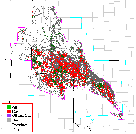
Morrow Sandstone Gas and Oil Stratigraphic Play
by Mitchell E. Henry and Timothy C. Hester
This play includes all Pennsylvanian Morrow Group sandstones and shales
and is oriented in a broad band that occupies most of the province,
except the part along the northeastern and southwestern edges of the
province where Morrowan age strata are absent, and that part included in
the Deep Stratigraphic Gas Play. Depths range from about 4,000 ft on
the northern shelf to 13,000 ft at the southern play boundary (upper
depth limit of the Deep Stratigraphic Gas Play). Similar to the
Springer Stratigraphic Gas and Oil Play but much more extensive, this
play is gas prone and accumulations are almost always trapped
stratigraphically in sandstone reservoirs.
Reservoirs
Reservoirs are all sandstones of the Morrow Group, and include the
Keyes, Puryear, Purdy, and Primrose sands. The Morrow Group ranges in
thickness from erosional truncation along the northeastern and
southwestern province boundaries to about 1,500 ft at the southern play
boundary (adjacent to the Deep Stratigraphic Gas Play). The predominate
lithology of Morrowan strata is shale but significant thicknesses of
sand exist, generally increasing from northwest to southeast.
Morrow Group sands are generally fine grained and often well cemented
(Pate, 1959). Reported porosities range from about 6 to 26 percent,
with an approximate median value of 13 percent; permeability ranges from
1 to 600 mD with an approximate median value of 20 mD. Reservoir
quality is expected to be good in much of the play area.
Source rocks
Because most reservoirs of this play are stratigraphically enclosed by
shale and mudstone, the most probable hydrocarbon source is Morrow Group
shales. Burruss and Hatch (1989) measured TOC values of selected
Pennsylvanian shales (including Morrow Group shales) as high as 18
percent and concluded that these rocks have good genetic potential.
However, Burruss and Hatch (1992) present evidence against a Morrowan
source for Morrowan reservoirs in western Kansas and southeastern
Colorado. Although Burruss and Hatch (1989) determined that Morrowan
organic matter is both oil and gas prone (kerogen types II and III), gas
is by far the most abundant resource produced from the Morrow Group.
Modeling by Schmoker (1989) and others suggests that Morrowan age rocks
in Oklahoma and Texas, and therefore most major hydrocarbon
accumulations in the Morrow Group, are at or above the thermal maturity
level required for the onset of oil generation (about Ro =
0.6 percent). In Kansas, Morrowan rocks are less mature.
Timing
Timing of petroleum formation and migration, and trap formation in this
play is favorable as evidenced by the fact that more than 330 major
accumulations have been discovered. Modeling by Schmoker (1989)
indicates that Morrowan rocks entered the thermal zone of oil generation
as early as 260 Ma in the southern part of the play, at about 50 Ma in
the central part of the play, and may not yet have entered the thermal
zone of oil generation in the northern part of the play. Hydrocarbon
migration has probably occurred over very short distances in most areas
of the play.
Traps
Traps types for reservoirs in the Morrow Group are almost exclusively
stratigraphic. Reservoir origins are interpreted as valley fill, beach
and offshore bar, and deltaic deposits (Rascoe and Adler, 1983). Seals
are generally formed by enclosing Morrowan shales and mudstones. Major
accumulations are distributed throughout western Oklahoma, Texas
Panhandle, and southwestern Kansas, with a few in southeastern Colorado.
Exploration status
More than 26,000 wells penetrate Morrowan rocks in this play. Of these,
more than 10,000 are hydrocarbon producers. Hydrocarbon production is
more or less centered in the play, with the southeastern and
northwestern ends being less productive. The northwestern part of the
play is least productive and least well explored. Of the 333 major
accumulations assigned to this play, 257 are gas and 76 are oil. The
largest gas accumulation is at Watonga-Chickasha Trend, with an
estimated ultimate recovery of 4.3 TCFG. The largest oil accumulation
is at Postle field, with an estimated ultimate recovery of 120 MMBO.
Resource potential
This play is well explored in Oklahoma and Texas but less so in Kansas
and Colorado. Future major hydrocarbon discoveries are expected,
however, in spite of the present exploration density. Most new
discoveries are expected to exist primarily in stratigraphic traps (R.A.
Northcutt, oral commun., 1993). Some factors limiting the potential for
new discoveries include the already high drilling density in many areas,
and the fact that in some apparently unproductive areas, Morrowan rocks
are composed of more shale and less sand (Rascoe and Adler, 1983). The
potential for future discoveries in this play is expected to be
moderately good. Trends in historical discoveries and completion data
were used to estimate undiscovered resources.
Play Map
References
Burruss, R.C., and Hatch, J.R., 1989, Geochemistry of oils and
hydrocarbon source rocks, greater Anadarko basin--evidence for multiple
sources of oils and long-distance oil migration, in Johnson,
K.S., ed., Anadarko Basin Symposium, 1988: Oklahoma Geological Survey
Circular 90, p. 53-64.
Burruss, R.C., and Hatch, J.R., 1992, Geochemistry of Pennsylvanian
crude oils and source rocks in the greater Anadarko basin--Oklahoma,
Texas, Kansas, Colorado, and Nebraska: An update [abs.], in
Johnson, K.S., and Cardott, B.J., eds., Source rocks in the southern
Midcontinent, 1990 Symposium: Oklahoma Geological Survey Circular 93,
p. 197.
Pate, J.D., 1959, Stratigraphic traps along north shelf of Anadarko
basin, Oklahoma: American Association of Petroleum Geologists Bulletin,
v. 43, p.39-59.
Rascoe, Bailey, Jr., and Adler, F.J., 1983, Permo-Carboniferous
hydrocarbon accumulations, Mid-Continent, U.S.A.: American Association
of Petroleum Geologists Bulletin, v.67, no. 6, p. 979-1001.
Schmoker, J.W., 1989, Thermal maturity of the Anadarko basin, in
Johnson, K.S., ed., Anadarko Basin Symposium, 1988: Oklahoma Geological
Survey Circular 90, p. 25-31.
Kansas Geological Survey, Digital Petroleum Atlas
Updated July 11, 1996
Comments to webadmin@kgs.ku.edu
URL=http://www.kgs.ku.edu/DPA/frontEnd/Anadarko/Morrow/provSum.html