Kansas Geological Survey, Current Research in Earth Sciences, Bulletin 253, part 2
Prev Page--Gradients || Next Page--Drainage System, Summary
![]()
![]()
![]()
Kansas Geological Survey, Current Research in Earth Sciences, Bulletin 253, part 2
Prev Page--Gradients ||
Next Page--Drainage System, Summary
![]()
Eastern Kansas has been affected to a surprising degree by subtle tectonic activity that has involved continued fracturing of the earth's crust (Merriam, 1963). The presence of the fractures in Kansas is not unique; for whatever their explanation, many are presumed to be geologically ancient. Many of these fractures have had profound influence on the evolution of the details of Kansas topography. We speak here of the so-called "fine-scale" fractures, whose presence has come to light only recently in Kansas through use of shaded-relief mapping of digitized elevation data in DTM files (Harbaugh and others, 2005). They can be observed in most parts of Kansas and are widely discernible in the midcontinent region.
The relationship between fine-scale fractures and conventional joints and faults is poorly known. The influence of joints and fractures on the topography of Kansas has been cited by various authors, most notably by Ward (1968) and White (1990). We suspect, however, that fine-scale fractures discerned on shaded-relief maps are fundamentally different and instead may represent components of the overall structure of the earth's crust. The evidence for such a system of fine-scale fractures presently is based solely on their presumed effect on topography, and to our knowledge the fractures themselves have not been observed directly. If a widespread system of fine-scale fractures is subsequently confirmed, it will be a significant advance in structural geology.
The term "fine-scale" is a relative term. Fractures (including faults) in the earth's crust range over a wide range of scales. Some extend for tens or hundreds of kilometers, whereas others are observable at hand-specimen or thin-section scales. The term "fine-scale"" is used in this context to denote fractures that are smaller than the scale of tectonic features of crustal importance, but connotes a scale substantially larger than the scale of features such as joints observed at an outcrop. In Kansas and the midcontinent region, at least, the fine-scale fractures are pervasive. Measurements in Kansas indicate that they generally occur in several distinctively oriented sets. Where fracture sets are well defined, parallel fractures are spaced about 250 to 400 m apart, but where they are less well defined, it is difficult to measure the spacing between them. Although the importance of these fine-scale fractures seems to have been only recently appreciated, indirect references to subtle linear features that affect soil color or topography have been noted for many decades. We may suspect, however, that fine-scale fractures are present worldwide and have had large influence on the evolution of the topography in many regions.
We can speculate that fine-scale fractures as well as other fractures whose presence is observed at the earth's surface, stem from fractures in the earth's rigid basement that have been propagated all the way to the surface through the overlying sedimentary sequence. For the most part, the fractures are not faults, at least not faults in the ordinary geological sense with perceptible vertical displacement. Instead, the fractures may involve only small vertical displacements in which the two sides of a fracture may move alternately upward and downward relative to each other over distances of perhaps a few centimeters, without creating an aggregate perceptible displacement. Thus, they seem not to be faults because significant vertical displacement would have been detected long ago.
Lineaments have been of interest for decades. Many are discernible especially on Landsat imagery (DuBois, 1978; McCauley and others, 1978: McCauley, 1988). Also faults and fractures have been mapped and measured as well as inferring them from topography and drainage patterns. Geophysical techniques also have been interpreted in light of alignments (Yarger, 1983; Lam, 1987). Recently Merriam and Davis (in press) made a statistical study of these directional data in the U.S. midcontinent, noting that three trends are dominant: northeast, east-northeast, and northwest.
Here we need to make the distinction between "fractures" and "lineaments." We regard fractures in the present context as controlling influences of the presence of features perceived as lineaments. We cannot see the fractures (at least not on shaded-relief maps), but we can see lineaments. Lineaments are usually subtle features that are more or less linear in extent and presumably do not represent faults with readily observable vertical displacement. On shaded-relief maps employed here (figs. 5 and 6, and figs. 11-13), perception of the lineaments stems solely from topographic features defined by differences in elevation in DEM files. No "tonal anomalies" that reflect differences in soil color or vegetation as seen usually on aerial photographs or Landsat images are present.
An immediate question is how could fractures have this much influence? Are these fractures actually faults along which slight vertical displacement has gone unrecognized? However, if they are faults, they must have scant vertical displacement, although alternatively they might have substantial lateral displacement that would be difficult to detect. So what are they? They seem to be fractures with very little, if any, displacement, but they nevertheless have had huge influence on the evolution of the landscape. What could cause them? We suggest that they are likely to be components of a fundamental fracture system that affects much or all of the earth's crust.
We may speculate about their origins. One widely suggested hypothesis is that they reflect continuing flexure of the crust in response to the tidal cycles. In other words, the flexures are the counterpart of the solid earth as it responds to the tides, although the responses are very different than the tidal responses of the sea.
Another view is that the fractures may stem from subtle back-and-forth tectonic tilting of the crust as it responds to gentle upwarping and downwarping on a regional basis, although the cycles of back-and-forth tilting would necessarily be vastly longer than the twice-daily cycle of the tides. Nevertheless, whatever the cause and the length of its cycles, the fracture system must be more or less continuously active and presumably is active at present.
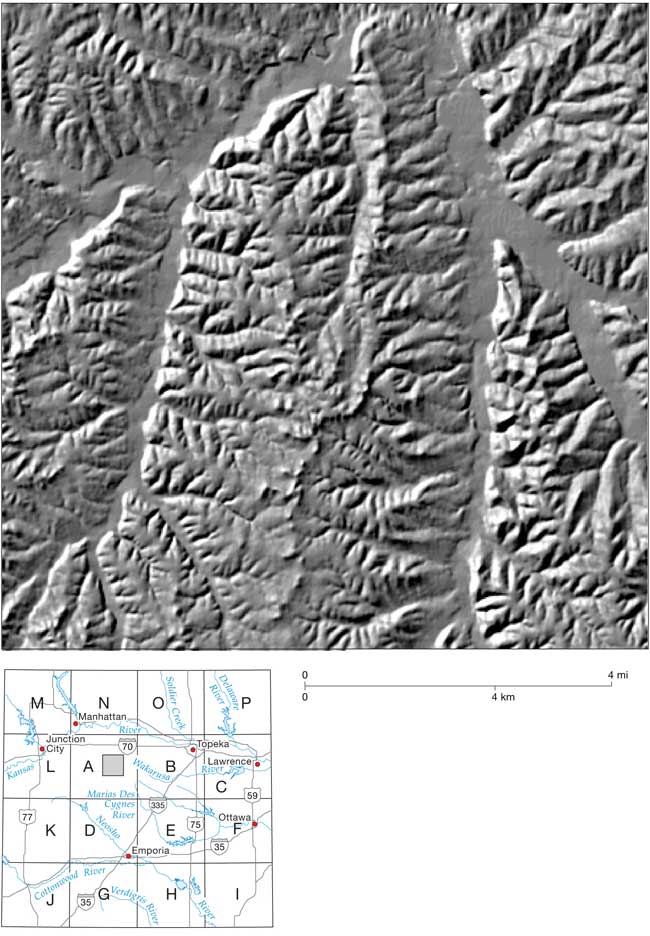
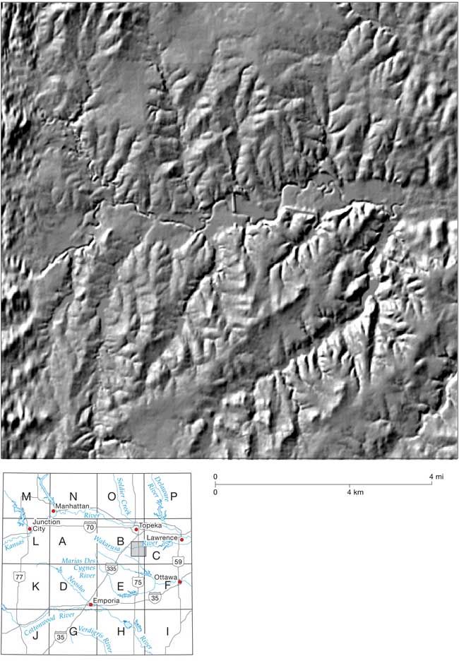
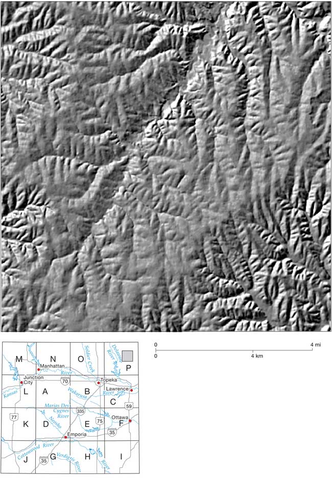
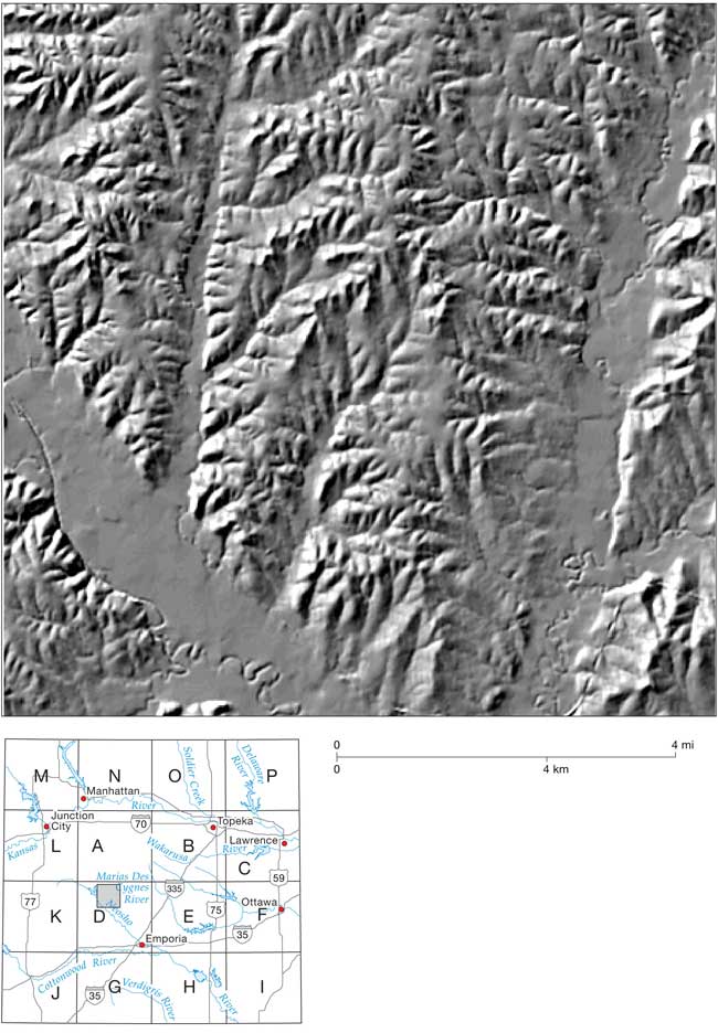
The influence of these fractures is revealed by shaded-relief maps of DEM data. Figure 5 is a composite shaded-relief map of the entire study area based on DEM files of 192 quadrangles (fig. 3), each spanning 7 1/2 minutes of latitude and longitude. Figure 5 reveals the immense complexity of the topography, which vaguely resembles seamed and wrinkled, old worn leather that has a decided "grain."
The topography, of course, has been shaped largely by erosion by running water, although supplemented by glaciation in the northern part of the area. The graininess of the landscape suggests that pervasive fracturing of the earth's crust has influenced the topographic detail by affecting the directions of the drainage network at a variety of scales. Viewed collectively, the influences usually appear as aggregations of "lineaments" for a range of scales.
How could fractures with negligible relative displacement have such a large influence on the topography? This issue is one of the most puzzling aspects of all. One explanation is that the fractures are zones of "weakness" that preferentially influence the direction of incipient stream valleys, although the form of the weakness is unknown. Alternatively, perhaps displacements of a few centimeters or a few tens of centimeters along a fracture might influence the direction of a newly evolving landscape, selectively shunting the surface runoff so it flows more or less parallel to the fracture, and thereby establishing the general direction of the stream. It is not clear what relationships exist between joints commonly observed at outcrops and the fine-scale fractures. Joints at outcrop scale are usually more closely spaced.
Some accord exists of the orientations of the fine-scale fractures and joints in rocks observed in outcrops, but the accord is relatively poor. Aber (1997) states that the dominant joint set in eastern Kansas strikes about N50°E to N60°E, and another is set at right angles. The orientations of some fine-scale fractures in the region accord with these orientations, but most do not. Relationships between fine-scale fractures and joints have yet to be resolved.
The lengths of the lineaments are poorly known. Some seem to extend for tens of kilometers, but others are only 2 or 3 km long or even less. Whether these lineaments actually reflect the presence of fractures of the same general length is problematical. Perhaps short discrete fractures tend to be arranged along straight lines, and the resulting lineaments appear to be long continuous features even though the fractures may be shorter. Most of the lineaments are straight, although some are curved. Their strike directions and "strengths" differ locally, and the shorter lineaments tend to exhibit preferred orientations. In some respects, though, the pattern of lineaments is deceptively complex.
Throughout the area, at least three sets of short, closely spaced "minor" lineaments can be identified. For convenience only the northern component of strike is given. One set trends about N10°W to N20°W, another about N70°W to N80°W, and yet another trends about N10°E, as shown in fig. 13, which has been excerpted from fig. 12. Their lengths are problematical, but many may be only 2 or 3 km long. Vast numbers of these short lineaments are present in the region, making it impractical to mark them on the shaded-relief map in fig. 12; otherwise they would cover the map. The spacing between parallel short lineaments is difficult to measure objectively, but a spacing of several hundred meters is usual in some localities. In Ford County, Kansas, for example, the spacing is about 250 m (Harbaugh and others, 2005). The areal density of these minor lineaments seems to differ, however, in part because of differences in the quality of the DEM data and the corresponding shaded-relief maps. Comparison of lineament spacing and density from place to place can be difficult.
Figure 12 represents the same shaded-relief mosaic as fig. 5, except that the pronounced lineaments have been interpreted and marked as an overlay. The lineament-interpretive process is somewhat subjective. Only the "prominent" larger lineaments have been marked, whereas the vast number of lesser lineaments could have been but were not marked. The principal types of lineaments are classified and described, and following that, prominent examples of larger "major" lineaments are discussed on a quadrangle-by-quadrangle basis employing the "large" quadrangles as outlined in figs. 1 and 12.
Figure 12--Shaded-relief mosaic for entire area (fig. 1) on which lines have been added to represent where prominent lineaments have been identified. Square areas labeled from A to P denote "large" quadrangles defined for purposes of discussion of properties of lineaments.
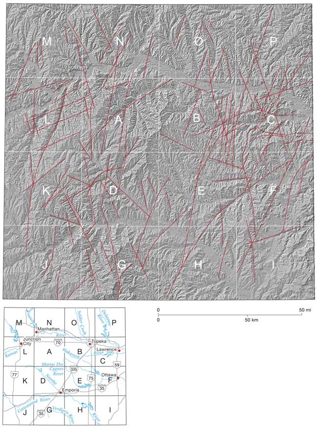
Figure 13--Examples of different sets of short lineaments. A, Set trending about N10°W, N10°E, and N70°W.
13B, Sets trending about N10°E, N10°W, and N60°E.
13C, Set trending N70°W is prominent, with another set trending N5°W less prominent.
13D, Set N10°W is prominent, with less prominent sets trending N70°W and N10°E.
Many of the prominent lineaments that have been marked on fig. 12 are long and straight, but the directions differ. Some are more or less in accord with the directions of the minor lineaments, whereas others range from N70°W to N45°E. The lengths are variable, ranging from less than 10 to more than 40 km. Wherever we interpret one of the longer lineaments, a dilemma usually exists as to whether the lineament is actually as long as it seems, or is it a visual apparition that stems from the eye's tendency to link shorter lineaments together? Given their subtle nature, it is difficult to distinguish between segments of straight short minor lineaments that line up, versus those lineaments that are truly longer.
Some of the lineaments curve, some gently differing in azimuth direction by only 5° or 10°, whereas others are more curvilinear. One prominent curvilinear feature (fig. 12) in the southeastern part of the overall area appears to extend for at least 100 km and trends in a general northeasterly direction. Others whose features involve curvatures of 30° or 40° are prominent in quadrangle "C" on fig. 12, where the radii of curvature range between about 5 and 10 km.
The prominent lineaments marked in fig. 12 are described according to their location with respect to the 16 "large" quadrangles labeled A through P. Each large quadrangle is composed of 12 standard 7 1/2-minute quadrangles, three 7 1/2-minute quadrangles north-south and four quadrangles east-west. Large quadrangles A to I are within the experimental area, and those labeled J to P extend the overall area in which lineaments have been mapped.
Quadrangle A: Three long gently curving lineaments stand out, of which two trend more-or-less north-northeast, whereas the third trends northeast. One of the north-trending lineaments can be traced across the Kansas River.
Quadrangle B: Several prominent lineaments occur in the western half of the quadrangle. Five elongate closely spaced north-northeast-trending lineaments in the eastern part of quadrangle are interesting. They extend from the northeastern part of quadrangle E, and the easternmost one can be traced into quadrangle C and onward northeast into quadrangle P.
Quadrangle C: Here several north-northeast-trending lineaments are prominent. Most notable, however, are curving lineaments with differing radii. One broadly curving lineament extends between B and C, with its eastern end virtually in Lawrence. A "swarm" of curving lineaments present in the southern part of C are particularly interesting because they curve so sharply.
Quadrangle D: Several prominent lineaments with azimuths ranging from northwest to north-northeast are present in this quadrangle. The most notable feature is the long straight course of the Neosho River valley, which trends almost exactly northwest. The profusion of small lineaments is impressive, particularly those that trend north-northwest.
Quadrangle E: Most notable is a north-northeast lineament that extends from Quadrangle H to Quadrangle B. In the north-central part of Quadrangle E, this lineament passes into two lineaments that diverge and gently curve toward northeast. Other notable features include the profusion of north-trending small lineaments.
Quadrangle F: Several curving lineaments are prominent, as well as a straight northeast-trending lineament that extends from Quadrangle I through F and into Quadrangle C. Two east-northeast-trending lineaments also are notable, one of which extends into Quadrangle E.
Quadrangle G: The prominent lineaments in this quadrangle are curved. In the eastern part of the quadrangle, small lineaments that trend more-or-less north are present with azimuths that range from slightly west of north, to slightly east of north.
Quadrangle H: A prominent lineament in this area splits with one part diverging and curving broadly toward the northeast, into Quadrangles E and F, and the other extending north-northeast into Quadrangles E and B.
Quadrangle I: The DTM quality is so poor that most lineaments are difficult to discern, although several have been marked.
Quadrangle J: Several gently curving lineaments are present.
Quadrangle K: Several prominent straight lineaments are seen, and a gently curving one that extends from J to L is evident. Several small lineaments trend north-northwest. Two straight valleys in the southeastern part of the quadrangle presumably represent important lineaments.
Quadrangle L: Several prominent east-northeast-trending lineaments, as well as a gently curving lineament, extend from Quadrangles K and J. North-northwest-trending small lineaments are notable.
Quadrangle M: The straight northwest-trending valley of the Big Blue River in the eastern part of the quadrangle (and extending into Quadrangle N) is particularly prominent and several north-northwest-trending small lineaments are notable.
Quadrangle N: Several prominent lineaments can be traced on both sides of the Kansas River floodplain. North-northwest-trending shorter lineaments are notable.
Quadrangle O: Several prominent lineaments can be traced on both sides of the Kansas River floodplain. North-northwest-trending small lineaments are notable.
Quadrangle P: Several prominent lineaments can be traced on both sides of the Kansas River floodplain. North-northwest-trending small lineaments are notable.
Prev Page--Gradients || Next Page--Drainage System, Summary
Kansas Geological Survey
Web version Dec. 26, 2007
http://www.kgs.ku.edu/Current/2007/Harbaugh/04_frac.html
email:webadmin@kgs.ku.edu