Kansas Geological Survey, Current Research in Earth Sciences, Bulletin 253, part 2
Prev Page--Start || Next Page--Gradients
![]()
![]()
![]()
Kansas Geological Survey, Current Research in Earth Sciences, Bulletin 253, part 2
Prev Page--Start ||
Next Page--Gradients
![]()
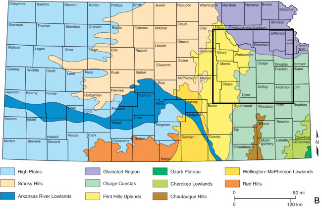
Kansas has interesting topography. Far from being a "featureless plain" as characterized by a few writers, Kansas' scenery is varied and intricate, and eastern Kansas particularly so. When considered in detail, the topography in eastern Kansas is astoundingly complex. This study focuses on an area of about 10,000 mi2 (25,900 km2) in eastern Kansas (fig. 1) that spans parts of several major drainage systems including (from north to south) the Kansas, Marais des Cygnes, Neosho, Verdigris, and Fall rivers (fig. 2A) and covers parts of three physiographic provinces, namely the Glaciated Area, Flint Hills, and Osage Cuestas (fig. 2B). The study area consists of two parts: 1) a smaller "experimental area" and 2) an extension of the area to the west and north to form the "overall area" as defined in fig. 3.
Figure 1--Index map showing location of the study area in eastern Kansas and its relation to the Flint Hills. The study area has been divided into "large" quadrangles labeled from A to P, which in turn are composed of 7 1/2-min topographic quadrangles identified in fig. 3. The "experimental area" includes large quadrangles A through I and denotes where experiments described have been conducted. "Overall area" includes quadrangles A though P and incorporates "extended area" to the west and north consisting of quadrangles J through P. Lineaments have been analyzed throughout the overall area.
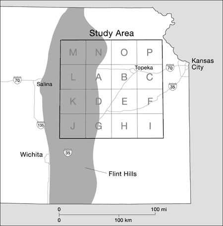
Figure 2A--Major streams and tributaries in Kansas. In eastern Kansas, drainage is toward the east and southeast.
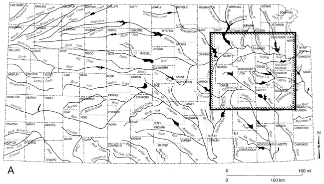
Figure 2B--Physiographic provinces in Kansas. Study area includes part of Glaciated Region, Flint Hills, and Osage Cuestas.
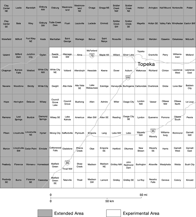
Recent technology has provided new ways of looking at topography that stem from digitizing of topographic maps. Kansas is covered completely by detailed, reliable 7.5-min topographic maps that have been produced by the U.S. Geological Survey in the past 55 years. These maps have been made by analog methods from stereoscopic coverage with aerial photographs. More recently, data represented as contour lines on the maps have been placed in digital form in a series of pixels, each 30 m square. The elevation of the land surface in each pixel has been estimated from the contour lines and recorded in meters above sea level to the nearest whole meter. The digitization of the topography has been done under contract to the Department of Defense, and the resulting files are known either as digital elevation models (DEMs) or as digital terrain models (DTMs). The DEM files are organized by topographic quadrangles, and those in the study area are identified in fig. 3.
Figure 3--Index map of topographic quadrangles in overall study area.
Placing topographic maps in digital form has many advantages. One major advantage is that the maps can be viewed in different ways. Instead of conventional contour lines, variations in elevation can be viewed as bands of color, or even more usefully, in the form of shaded-relief (hillshade) maps. Although the data represented in shaded-relief maps have been derived from conventional topographic contour maps, the shaded-relief maps may provide more geologically useful information than the contour maps on which they are based.
A second major advantage of DEMs is that they can be manipulated by computer using the powerful computing procedures provided by geographic information systems (GIS). Because all the information is in digital form, different topographic surfaces can be combined or contrasted digitally, and the details of the surfaces analyzed numerically. Using software commercially known as ArcInfo© developed by the Environmental Systems Research Institute (ESRI), of Redlands, California, we combined information from DEMs with digitized geological mapping of the high-level chert gravels.
Overall, the geology of Kansas is relatively simple. It consists of a "layer-cake" sequence of sedimentary rocks as well as unconsolidated sediments ranging in age from Cambrian to Holocene, which overlie the Precambrian crystalline basement (Merriam, 2006; fig. 4). The topography in eastern Kansas reflects this simplistic geology and has been shaped by erosion of the sequence of alternating thin beds of Permian-Pennsylvanian sedimentary rocks that dip gently to the west. Limestone units underlain by shales and sandstones tend to form cuestas that face eastward, with gentle dip slopes to the west. So, traversing the stratigraphic section from west to east is similar to going through pages of a book starting at the beginning in the west and proceeding to the oldest (the end) in the east.
Figure 4--Schematic stratigraphic section for eastern Kansas. Rocks older than Mississippian are known in subsurface only.
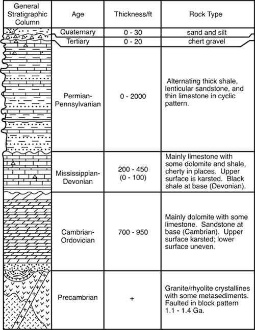
The northern part of the study area has been glaciated, so there the Permian-Pennsylvanian units tend to be concealed by Pleistocene glacial deposits. Details of the topography, however, are not as simple as this brief description might imply. South of the glacial boundary, the westerly tilted Permian-Pennsylvanian beds have been shaped by a complex history of fluvial erosion as streams have cut through the generally north-south-trending cuestas. Although the topography is not rugged in the sense of mountainous terrain, nevertheless, the slopes are steep in places so that the local topographic relief can be considerable; the relief in a lateral distance of a km or two may be as much as 60 or 70 m. In places over a span of 6 or 8 km, the relief may be as much as 150 m. Clearly, eastern Kansas is not a featureless plain.
Figure 5 is a shaded-relief map that attests to the overall complexity of the topography of the study area. The trunk streams flow either to the east or southeast (fig. 2A). We may presume that overall drainage directions to the east and southeast have prevailed for a long time, perhaps for much of the Cenozoic, although there have been important changes in the drainage system during this time. Notably, the course of the Kansas River, which is the largest river in the area and a major tributary of the Missouri River, and in turn of the Mississippi River, was influenced by glaciation. Most of the area south of the Kansas River in eastern Kansas, however, has not been glaciated (fig. 2B).
Figure 5--Mosaic of DEM files in study area represented in shaded-relief form. Angle of sun is 45° from horizon, and sun shines from azimuth angle of N45°W. Pronounced variations in quality of DEM files are evident from quadrangle to quadrangle. Files for some quadrangles yield sharp shaded-relief images, whereas others are blurred. Differences stem from variations in digitizing work carried out by contractors for the U.S. Department of Defense. DEM information has served as the principal source of elevations for experiments described here, as well as for mapping of lineaments. White lines denote outline of "experimental" area within "overall" study area.
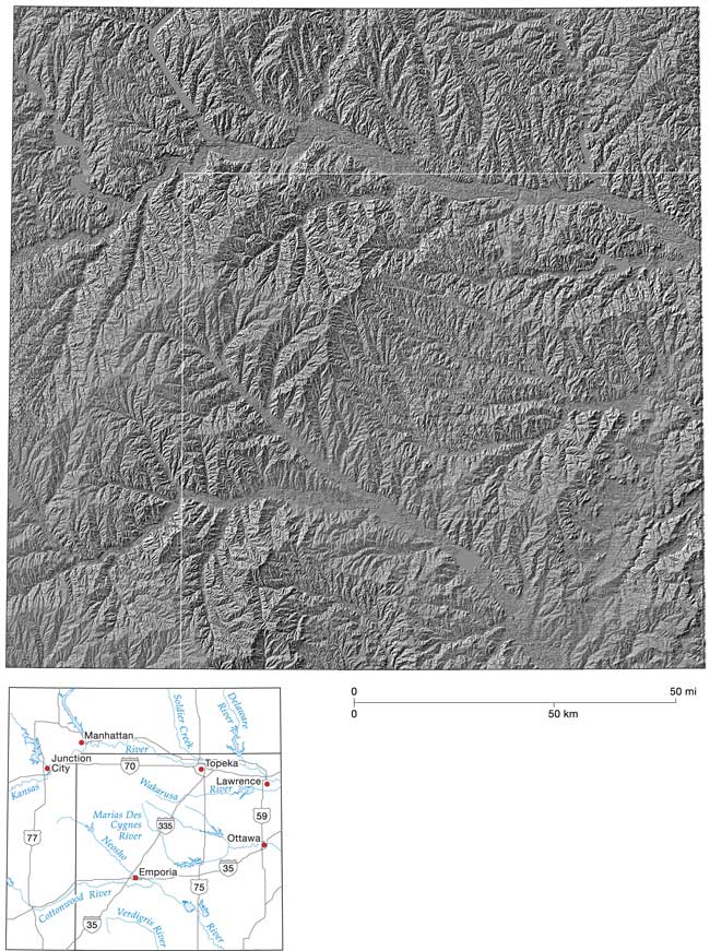
The streams in eastern Kansas have evolved during a considerable length of time, perhaps for as much as five or ten million years or even longer. Whatever span of time is presumed, however, is a generalized guess for which we have limited evidence. In glaciated northeast Kansas, however, the topographic details may be more recent.
Prev Page--Start || Next Page--Gradients
Kansas Geological Survey
Updated Jan. 8, 2008
http://www.kgs.ku.edu/Current/2007/Harbaugh/02_intro.html
email:webadmin@kgs.ku.edu