Kansas Geological Survey, Current Research in Earth Sciences, Bulletin 252, part 2
Prev Page--Start || Next Page--Stratigraphic Characteristics
![]()
![]()
![]()
Kansas Geological Survey, Current Research in Earth Sciences, Bulletin 252, part 2
Prev Page--Start ||
Next Page--Stratigraphic Characteristics
![]()
The placement of the Carboniferous (Pennsylvanian)-Permian boundary in Kansas, and in all of North America, has been debated since the rocks of this age were first described and named in the midcontinent. In Kansas, at least 84 references have expressed an opinion as to where the boundary should be placed (e.g. Moore, 1940; Moore, 1949; Mudge and Yochelson, 1962; Baars, Ritter, et al., 1994). Until recently, the fundamental problem of defining the boundary has been the inability to confidently tie the North American section to the type Carboniferous-Permian in Eurasia, primarily because the type area was never clearly defined (Mudge and Yochelson, 1962; Baars, 1990). Many correlations were based on fusulinids, including the latest proposed revision in Kansas (Baars, Ross, et al., 1994). With the ratification of the Global Stratotype Section and Point (GSSP) for the base of the Permian System in the southern Ural Mountains by the International Union of Geological Sciences (IUGS) (Davydov et al., 1998), the Carboniferous-Permian boundary in Kansas can now be confidently defined. Based on new conodont data that definitively correlate the Kansas rock section to the basal Permian GSSP, the Carboniferous-Permian boundary in Kansas can be placed at the base of the Bennett Shale Member of the Red Eagle Limestone (fig. 1).
Figure 1--Placement of the Carboniferous (Pennsylvanian)-Permian boundary in the latest accepted stratigraphic guide and chart for Kansas (modified from Zeller, 1968) compared to the placement described in this report.
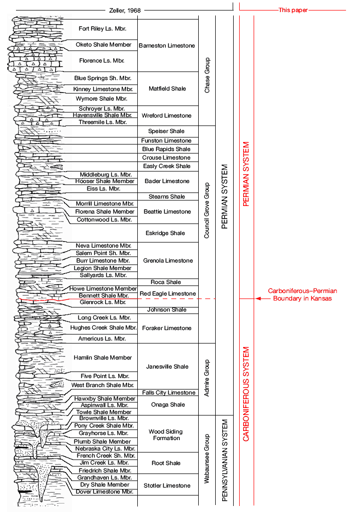
The occurrence of Permian rocks in Kansas, based on fossils collected by Major Frederick Hawn, was first announced by Swallow (1858a, 1858b). Early studies recognized the difficulty of defining the Carboniferous-Permian boundary in Kansas because the rocks seemed to contain a mixed assemblage of Carboniferous and Permian marine fossils, and a clear stratigraphic unconformity or lithologic change was not recognized. Several boundaries, ranging from the Fort Riley limestone (Chase Group) down to the Americus limestone (Council Grove Group) (current terminology), were advanced (see Moore, 1940, 1949). Moore and Moss (1934) reported what they believed to be a major disconformity, traceable from Nebraska to Oklahoma, above the Brownville Limestone Member of the Wood Siding Formation. By 1940, the top of the Brownville limestone, although generally recognized as somewhat arbitrary, had become the accepted boundary between the Carboniferous and Permian in Kansas. Mudge and Yochelson (1962) studied the stratigraphy and paleontology of the uppermost Carboniferous (Pennsylvanian) and lowermost Permian rocks in Kansas and found no evidence for placing the systemic boundary at the top of the Brownville limestone, but suggested leaving the boundary there because it had become firmly entrenched in the literature. The latest accepted stratigraphic guide and chart for Kansas (Zeller, 1968) retained this boundary placement. The boundary remained at the top of the Brownville limestone until Baars, Ross, et al. (1994) proposed moving it upsection to the base of the Neva limestone, a member of the Grenola Limestone. Baars, Ritter, et al. (1994) then elevated the Neva limestone to formation status.
Historically, ammonoids and fusulinids have been the primary index fossils used to establish a biostratigraphic framework for the Carboniferous and Permian. Ammonoid cephalopods have been considered useful because of their relatively rapid rate of evolution, readily recognizable morphological changes, and their pelagic/nektonic mode of life, which resulted in their wide geographic distribution. However, ammonoid fossils are only locally abundant in Carboniferous-Permian strata, and recent studies (Boardman et al., 1994) suggest longer periods of morphological stability than previously thought.
Because of their small size, abundance, rapid evolutionary rate, and readily recognizable morphological differences, fusulinids also are useful in establishing a biostratigraphic framework, particularly in the subsurface. However, their benthic lifestyle and general habitation of shallow normal marine paleoenvironments limits their distribution; thus, they can be absent from critical stratigraphic intervals in the diverse cyclic stratigraphic sections in the Carboniferous and Permian of Kansas.
Spores and pollen have potential for wide geographic dispersal but are not sufficiently diagnostic to permit identification of the Carboniferous-Permian boundary.
Conodonts, an apatitic tooth-like microfossil that are internal structures of pelagic animals, are widely distributed both in space and time, and have become the most widely used index fossils in Paleozoic marine strata. Sweet (1988, p. 149) stated "conodont species may be collected from sedimentary rocks that represent a wide variety of depositional environments. In addition, many conodont species have been shown to have had a very broad geographic distribution, and a few may have been cosmopolitan. Those facts, together with the elongate, worm-like body and distinctively finned tail of the few complete specimens known, support the generally held conclusion that the animals were probably nektonic in habit and that distribution of most species may have been largely independent of conditions on the bottom." Conodonts have become the best biostratigraphic tool for studies of the Carboniferous-Permian sequences because they are abundant and widely distributed, and they evolved rapidly over short periods of geologic time.
The GSSP for the base of the Permian System (and base of the Asselian Stage) is located at Aidaralash Creek, Aktöbe region, southern Ural Mountains, northern Kazakhstan (Davydov et al., 1998). The boundary interval occurs within a mudstone-siltstone-fine sandstone lithofacies that is completely within a maximum flooding unit free of disconformities (Wardlaw, Davydov, et al., 2004).
The GSSP is defined by the first occurrence of the conodont Streptognathodus isolatus, which developed from an advanced morphotype in the S. wabaunsensis chronocline (Chernykh et al., 1997). The first occurrences of Streptognathodus invaginatus and S. nodulinearis, also morphotypes of S. wabaunsensis, nearly coincide with the first occurrence of S. isolatus and can be used as accessory indicators for the boundary (Davydov et al., 1998).
The Carboniferous-Permian GSSP closely approximates the traditional boundaries that were defined by ammonoid cephalopods and fusulinacean foraminifers. The traditional ammonoid boundary is 26.8 m (88 ft) above the GSSP and is represented by the termination of the Prouddenites-Uddenites lineage and the introduction of the Permian taxa Svetlanoceras primore and Prostacheoceras principale (Davydov et al., 1998). Using ammonoids to identify the Carboniferous-Permian boundary at the GSSP is problematic because 1) ammonoids of critical stratigraphic significance are rare, 2) an interval of 27.5 m (90 ft) exists between the last documented Carboniferous ammonoid and the first Permian occurrence, and 3) most ammonoid species from the Ural Mountains appear to be endemic (Davydov et al., 1998).
The traditional fusulinid boundary is 6.3 m (21 ft) above the GSSP and is defined at the first occurrence of the inflated schwagerinids of the Sphaeroschwagerina vulgaris aktjubensis-S. fusiformis Zone (Davydov et al., 1998). Davydov et al. (1998) listed three reasons why fusulinids present a significant problem in defining the Carboniferous-Permian boundary: 1) fusulinids were benthic organisms making their distribution somewhat provincial, 2) most were confined to shallow-water carbonate facies, but may have been redeposited in deeper water facies or reworked from older deposits, and 3) taxonomy is in a state of flux and regional interpretations vary substantially.
The palynology of the Carboniferous-Permian boundary stratotype at Aidaralash Creek in Kazakhstan has been investigated by Dunn (2001). He examined palynological residues from 16 samples from a 50-m (164-ft) interval--from 24.2 m (79 ft) below to 26 m (85 ft) above the boundary. His results indicate that this interval is similar to that referred to as the Limitisporites monstruosus-Vittatina costabilis assemblage zone reported by Utting (1989) from the Artinskian of the Sverdrup basin in the Canadian Arctic. Dunn also documented a decrease in the relative abundance of palynomorphs across the conodont-defined Carboniferous-Permian boundary, with only two of the 22 palynomorph taxa identified as being exclusively Gzhelian (uppermost Carboniferous) and only one exclusively Asselian (lowermost Permian). The two exclusively Gzhelian taxa occur 5.1 m (17 ft) and 7.1 m (23 ft) below the boundary and the one Asselian taxon occurs 7.4 m (24 ft) above the boundary (Dunn, 2001, fig. 4).
Prev Page--Start || Next Page--Stratigraphic Characteristics
Kansas Geological Survey
Web version July 19, 2006
http://www.kgs.ku.edu/Current/2006/sawin/02_intro.html
email:webadmin@kgs.ku.edu