Kansas Geological Survey, Current Research in Earth Sciences, Bulletin 250, part 1
Prev Page--Precambrian || Next Page--Phanerozoic Fracturing and Faulting
![]()
![]()
![]()
Kansas Geological Survey, Current Research in Earth Sciences, Bulletin 250, part 1
Prev Page--Precambrian ||
Next Page--Phanerozoic Fracturing and Faulting
![]()
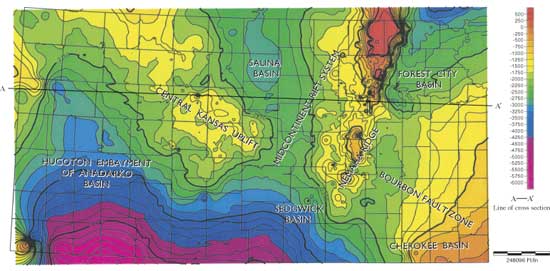
Although Kansas has no exposures of its Precambrian rocks, more than 1,000 drill holes have sampled the Precambrian. Cole (1976) used that control and extrapolated control based on the top of the Arbuckle and other tests to construct a basement-configuration map of the Precambrian subcrop. Cole mapped numerous normal faults that he identified by well control. The present topographic relief on the top of the Precambrian surface reflects the major geologic structures of Kansas (fig. 4).
Figure 4--Map showing topographic (structural) relief on the present Precambrian/Phanerozoic surface. Major geologic structures of Kansas are labeled (T. Carr, personal communication, 2003). A-A' is line of section for fig. 5.
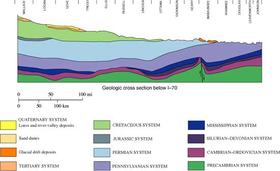
Analysis of early structures in Kansas can be found in Merriam (1963), Baars (1995), and Berendsen (1999) and their citations. Serpa et al. (1989) published seismic profiles through the Midcontinent Rift that illustrate their interpretation of the normal fault geometries responsible for the downdropping of the rift bottom, a series of moderately dipping normal faults (fig. 5).
Figure 5--Fig. 5. Diagrammatic cross section across Kansas showing normal faulting along the Nemaha, the traditional interpretation. Kansas Geological Survey. Line of section is A-A' on fig. 4.
The residual portion of the rift graben in Kansas containing Precambrian sedimentary and layered igneous rocks (Rice Formation [Scott, 1966]; see Bickford et al., 1979; Bickford et al., 1986 for distribution) lies well to the west of the most pronounced present-day topographic/structural anomaly of the Precambrian surface (but of Pennsylvanian elevation). That anomaly, the Nemaha "Ridge," trends north-northeast through the eastern third of Kansas. Berendsen (1997) named several fault zones that cut the Nemaha and summarizes much that is known about the displacement on each. Adjoining the Nemaha at nearly right angles, trending northwest, is the Central Kansas uplift, the other major positive relief structure in the subsurface of Kansas, which connects to the Cambridge Arch in Nebraska. The juncture of these two structures, the Midcontinent Rift/Nemaha Ridge and the Central Kansas uplift, forms the southern entrance to the Salina basin.
Prev Page--Precambrian || Next Page--Phanerozoic Fracturing and Faulting
Kansas Geological Survey
Web version Sept. 15, 2004
http://www.kgs.ku.edu/Current/2004/Gerhard/04_struct.html
email:webadmin@kgs.ku.edu