![]()
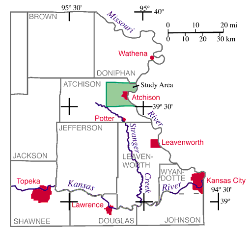
Fig. 1. Map of northeast Kansas, showing the location of the study area (green shaded area) and locations mentioned in the text.
The objectives of the pilot project were to produce a landslide inventory map (Ohlmacher, 2000) and a landslide susceptibility map for a region near the Kansas City metropolitan area. An inventory map shows the locations of landslides and related features, whereas a susceptibility map ranks the degree to which parts of the study area are prone to future landslides, based on the factors that produced past landslides. (A landslide susceptibility map does not provide information on how often landslides occur, as in a landslide hazard map, or the extent of damages and injuries that might be anticipated from a future landslide event, as in a landslide risk map.) A landslide event is defined as one or more landslides occurring during a limited time frame--for example, during and following a severe rainstorm. A landslide susceptibility map requires detailed information on the factors causing landslides, including slope morphology, geology, and soils. This report presents information on the causal factors collected as part of the pilot study.
Atchison is presently unaffected, or only marginally affected, by the growth of the Kansas City metropolitan area. Except for some growth in the 1920's and in the late 1990's, both the city and county have seen a slow, steady decline in population, and this decline is projected to continue in the near future (Helyar, 1999). However, new homes being constructed in and to the south of Atchison suggest that growth may be on the rise.
The study area around Atchison lies within the Glaciated Region physiographic province, whereas Kansas City straddles the boundary between the Glaciated Region and the Osage Cuestas. Although this might imply geologic differences between the two areas, the surficial geology around Atchison and Kansas City is fairly similar. The rocks at the surface in both areas consist of glacial drift, loess, bedrock, and alluvium, although the Kansas City area has less glacial drift and more bedrock. The topography of both Atchison and Kansas City is controlled by the Missouri River and its tributaries. Geologic similarities, the potential for population growth, and the proximity to Kansas City made Atchison a suitable location for the pilot project.
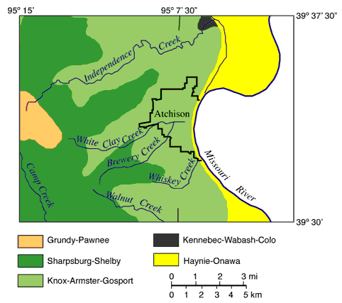
Fig. 2. Map of the study area showing the soil associations as defined by the National Resources Conservation Service (Sallee and Watts, 1984). Soil associations are regions with similar soil series, slope morphology, and drainage characteristics.
The National Resources Conservation Service (NRCS) has published a soil survey of Atchison County that identifies the soil series present in the county and provides some data on soil properties (Sallee and Watts, 1984). A soil series is a class of soils with similar soil profiles including horizons, color, texture, structure, composition, and other properties. Sallee and Watts (1984) recognized 19 soil series in Atchison County. The units used on the detailed soil maps consist of one or more soil series. Additionally, Sallee and Watts (1984) divided Atchison County into seven soil associations based on patterns of soil series, slope, and drainage. Of the seven soil associations, five are found in the study area (fig. 2). These can be lumped into three groups: soils in gently rolling terrain, soils on hilly terrain, and lowland soils.
The western part of the county has gently rolling terrain that exposes soils of the Grundy-Pawnee and Sharpsburg-Shelby associations. These are deep soils, developed on glacial drift and loess, on level to moderate slopes. Deep soils are those where bedrock is at least 152 cm (60 in) below the surface. The Sharpsburg-Shelby Association occurs in areas with slightly more relief than Grundy-Pawnee Association.
The Knox-Armster-Gosport Association is exposed in the hilly terrain in the central portion of the study area. This association consists of shallow to deep soils on strongly sloping to steep hillsides. Gosport Series are thinner and develop on bedrock, Armster Series develop on glacial drift, and Knox Series develop on loess. Knox-Armster-Gosport Association also contains small areas of Vinland Series that develop on shales.
The lowland areas include the floodplains of the Missouri River and its tributaries. In this area, Kennebec-Wabash-Colo and Haynie-Onawa associations are dominant. These are deep soils developed on alluvium, on level to gently sloping land.
Kansas Geological Survey
Web version December 22, 2000
http://www.kgs.ku.edu/Current/2000/ohlmacher/ohlmacher2.html
email:lbrosius@kgs.ku.edu