


Kansas Geological Survey, Current Research in Earth Sciences, Bulletin 243,
part 1
Sedimentology and Ichnology of Paleozoic Estuarine and Shoreface Reservoirs, Morrow Sandstone, Lower Pennsylvanian of Southwest Kansas, USA--page 2 of 14

Introduction
Integration of facies and trace-fossil evidence tests and refines depositional models constructed solely on the basis of physical sedimentology. In recent years, the petroleum industry has increasingly used trace-fossil analysis of cores as an aid in reservoir characterization. In particular, ichnologic data have been instrumental in the recognition of estuarine deposits and their distinction from open-marine facies (e.g., MacEachern and Pemberton, 1994). Previous ichnologic analyses of cores, however, have concentrated on post-Paleozoic reservoirs (e.g., Bockelie, 1991; Pemberton, 1992; Taylor and Gawthorpe, 1993; Howell et al., 1996; Martin and Pollard, 1996; MacEachern and Pemberton, 1997). The present study represents one of the first attempts to apply trace-fossil analysis to cores from Paleozoic reservoirs.
The Lower Pennsylvanian Morrow Sandstone contains oil and gas reservoirs in a wide variety of shallow and marginal-marine depositional environments. Delta-front, shoreface, and estuarine valley-fill reservoir sandstones are encased in offshore and estuarine mudstones (Sonnenberg, 1985; Krystinik and Blakeney, 1990; Sonnenberg et al., 1990; Wheeler et al., 1990). An integrated stratigraphic, sedimentologic, and ichnologic study provides a more accurate characterization of reservoir facies and geometry. This study allows distinction between marine-shoreface and estuarine valley-fill sandstones from four cores of the lower Morrow in southwestern Kansas. Core analysis subsequently was integrated with well-log information. Previous studies have emphasized the presence of estuarine valley-fills in the upper Morrow (Wheeler et al., 1990). Our integrated approach extends the estuarine valley interpretation into the lower Morrow. Within the midcontinent, trace fossils are useful in distinguishing different facies in estuarine incised valleys and marine shorefaces. Detailed study of biogenic structures provides high-resolution information to solve problems in facies, stratigraphic, and reservoir modeling. In some cases, they represent the only evidence available to develop a reasonable picture of depositional conditions and to estimate reservoir heterogeneity. The present study provides a detailed analysis of the sedimentary facies, documents the associated trace fossils, and illustrates how trace fossils are used to refine environmental interpretations of the lower Morrow sandstone reservoirs.
Geologic and Stratigraphic Framework
The Morrow Sandstone (Kearny Formation) in the subsurface of southwest Kansas, southeast Colorado, and northwest Oklahoma (fig. 1) includes rocks that lie immediately below strata of Atokan age and immediately above Mississippian rocks (Sonnenberg et al., 1990). This formation has been divided into two informal units: lower and upper Morrow (Swanson, 1979). The lower Morrow traditionally has been interpreted mainly as offshore shales and shoreface sandstones, though more recently Breyer (1995) documented an estuarine valley in lower Morrow cores from Oklahoma. The upper Morrow was interpreted as marine shales that encase transgressive valley-fill sequences (Wheeler et al., 1990; Krystinik and Blakeney, 1990). Marginal- and shallow-marine deposits of the Morrow Sandstone accumulated in the Hugoton embayment, which stretched into Kansas and Colorado from the deeper-water Anadarko basin in Oklahoma (Krystinik and Blakeney, 1990; Krystinik and Blakeney-DeJarnett, 1997). This embayment was flanked by a series of tectonic positive areas resulting from orogenic movements due to the collision between the North American and South American-African plates during the Late Mississippian to Early Pennsylvanian (Rascoe and Adler, 1983; Sonnenberg et al., 1990). These topographic highs, including the Front Range, the Cambridge arch-Central Kansas uplift, the Amarillo-Wichita uplift, the Apishapa uplift, and Las Animas arch, were important sedimentary sources for Morrow clastics (Sonnenberg, 1985; Sonnenberg et al., 1990).
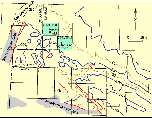
Fig. 1. Isopach map of the Morrow Sandstone showing location of the Arroyo and Gentzler fields in southwest Kansas. Contour interval = 250 feet (76.2 m).
The lowest sea levels in the Carboniferous occurred during the Morrowan and strongly affected sedimentation (Ross and Ross, 1988). Wheeler et al. (1990) recognized seven estuarine-valley sequences in the upper Morrow. Incision at the base of each sequence resulted from sea-level drop, with valley infill occurring during the subsequent sea-level rise (Wheeler et al., 1990; Krystinik and Blakeney, 1990; Krystinik and Blakeney-DeJarnett, 1997). During sea-level lowstands, valleys were incised into older shelf-deposits and the basin was drained to the shelf-slope break located in Oklahoma in the Anadarko basin (Sonnenberg, 1985; Sonnenberg et al., 1990). During highstands, valleys were backfilled, and a broad shelf covered the area (Sonnenberg, 1985; Sonnenberg et al., 1990; Wheeler et al., 1990). Incised valleys in the upper Morrow are oriented along a northwest-southeast axis (Sonnenberg et al., 1990; Wheeler et al., 1990).
The Study Area
This study is based on the analysis of cores from the Gentzler and Arroyo oil and gas fields. The Gentzler field is one of a group of Morrow gas reservoirs located in northwest Stevens County, Kansas (fig. 2). Two cores of the lower Morrow in this field were examined as part of this study. The Anadarko Petroleum Corp. Gaskill No. 10-2 (C SE sec. 10, T. 33 S., R. 38 W.) recovered 133 ft (40.5 m) of core (5,952-6,085.5 ft; 1,814. 2-1,854.9 m; datum is ground level) and penetrated 19 ft (5.8 m) below the base of the Pennsylvanian-Mississippian erosional contact. The Anadarko Petroleum Corp. Nell "A" 19-1 (C W/2 NE, sec. 19, T. 33 S., R. 37 W.) recovered 42 ft (12.8 m) of core (6,036-6,078 ft; 1,839.8-1,852.6 m) beginning above the lower Morrow sands and ending above the base of the formation. The Arroyo field in Stanton County, Kansas, was discovered in 1990 (fig. 3). Cores were examined across the lower Morrow interval from the Huber Kendrick 23-1 (C NW NE NW, sec. 23, T. 29 S., R. 41 W.) and the Huber Fretz 16-1 (C NE NE NE, sec. 16, T. 29 S., R. 41 W.). The Kendrick 23-1 recovered 85 ft (26 m) of core from 5,375-5,460 ft (1,638.3-1,664.2 m), beginning above the Pennsylvanian-Mississippian contact and ending below the top of the lower Morrow. The Fretz 16-1 recovered core from 5,399-5,452 ft (1,645.6-1,661.8 m) across the Pennsylvanian-Mississippian erosional contact but did not recover Morrow reservoir-quality sand.
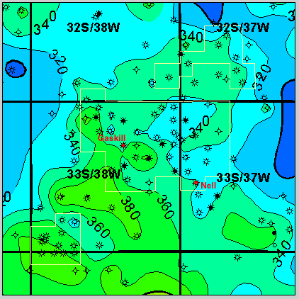
Fig. 2. Isopach map of the lower Morrow Sandstone in the Gentzler field showing location of Gaskill No. 10-2 and Nell "A" 19-1 wells. Contour interval = 20 feet (6.1 m).
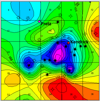
Fig. 3. Isopach map of the lower Morrow Sandstone in the Arroyo field showing location of Kendrick 23-1 and Fretz 16-1 wells. Contour interval = 10 feet (3 m).
Kansas Geological Survey
Web version November 9,1999
http://www.kgs.ku.edu/Current/1999/buatois/buatois2.html
email:lbrosius@kgs.ku.edu