


Kansas Geological Survey, Current Research in Earth Sciences, Bulletin 240,
part 3
Chert Gravel and Neogene Drainage in East-central Kansas--page 2 of 15

INTRODUCTION
Eastern Kansas south of the limit of glaciation is part of the Osage Plains of the central United States. This region is commonly portrayed as a tectonically stable terrain of low relief, in which near-peneplain conditions prevail. Widespread seismic activity and recent fault movements (Madole et al., 1991), however, suggest that the region may not be as stable as once thought. In eastern Kansas, considerable erosion of the landscape has taken place since Miocene time. Alluvial deposits of chert gravel of presumed Miocene, Pliocene, and Pleistocene ages are widespread and abundant on drainage divides, isolated hilltops, and high terraces throughout eastern Kansas (fig. 1). High-terrace chert gravels mostly are associated with existing stream valleys. In contrast, hilltop chert gravels in many places bear no obvious relationships to any river systems of today. Many, but not all, of these gravels on high terraces and hilltops contain quartzite and other exotic pebbles derived from the High Plains or Rocky Mountains to the west.
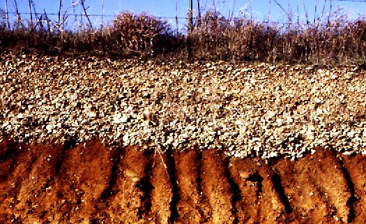
Fig. 1. Typical exposure of alluvial chert gravel, about 1 m (3 ft) thick, resting on weathered sandstone, on uplands north of Neosho River valley, east of Emporia, Kansas.
Kansas Geological Survey
Web version March 18, 1998
http://www.kgs.ku.edu/Current/1997/aber/aber2.html
email:lbrosius@kgs.ku.edu