
|

|
Resource Assessment
|
The purpose of the CO2 Resource assessment is to locate the sources and
quantities of carbon dioxide from electric utilities in Kansas. An on-going
project at KU and KGS involves assessing the potential for enhanced oil
recovery in Kansas using miscible-CO2 flooding. The CO2 Resource
Assessment from power plants is peripheral to this project.
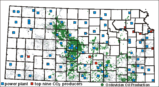
This map shows the location of power plants in Kansas overlain on Ordovician oil
and gas fields in Kansas. Both the blue and red squares signify the
location of power plants. The red squares specify the top ten largest
power plants, based on yearly emissions of CO2. Click on the map to view
information on CO2 production from the plants.
All fields ||
Lansing-Kansas City ||
Mississippian ||
Viola ||
Simpson ||
Arbuckle ||
Ordovician
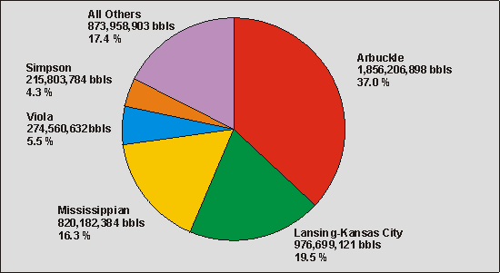
Percentage of Kansas oil production from various formations
Over half the oil production in
Kansas has come from Arbuckle and Lansing-Kansas City oil fields
References:
Individual power plant data is based on the summer and winter capabilities
as presented in Inventory of Power Plants in the United States, As of
January 1, 1998
(http://www.eia.doe.gov/cneaf/electricity/ipp/ipp_sum.html) ,
DOE/EIA-0095(98), Dec. 1998, pp. 112-119.
The emissions of CO2 are based on the assumption that each plant operates
at full-capacity using the primary fuel.
Emission factors for fuels are: 962 kg CO2/MWeh coal,
726 kg CO2/MWeh oil, 484 kg
CO2/MWeh natural gas (Source: Greenhouse Gas Emissions:
The Energy Dimension. 1991, Paris: The Organization for Economic Cooperation
and Development/International Energy Agency (OECD/IEA). p 199.)
The assumed value of CO2 is $0.50 per MSCF (Thousand Standard
Cubic Feet).
Kansas Geological Survey
Updated May 1999
Technical comments or questions to Scott White, KU Energy Research Center
Web comments to webadmin@kgs.ku.edu
URL=http://www.kgs.ku.edu/CO2/resource/index.html