Why a Construction Material Inventory Website?
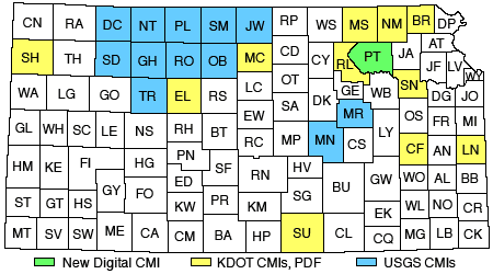
In the past 50 years, both Federal and State agencies have produced printed county inventories that contained information regarding the quality, quantity, and location of various natural resources that could be useful in the construction of roads and buildings. The United States Geological Survey (USGS) has printed material inventories in 20 Kansas counties from 1947 to 1959. State of Kansas agencies, including the Kansas Department of Transportation (KDOT), produced 36 county construction material inventories from 1963 to 1982. Some USGS county inventories overlapped with KDOT publications. These inventories proved to be of great utility to state transportation employees, geologists, and private industry. Despite the age of some of the documents they remain a handy reference tool today.
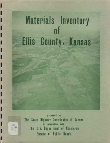
Inventories contained an overview of the geological history and stratigraphy germane to the area, photographs of outcrops from road cuts and quarries, and location maps depicting sites where specific materials could be found (sand, aggregate, clay). For some sites, material laboratory analysis information (e.g., aggregate specific gravity, absorption, soundness ) was available. Some USGS publications contained numerous measured sections of rock exposures.
As valuable as these inventories were and continue to be, similar information was not available in the majority of Kansas counties, and the inventories themselves were static, one-time only publications. Today, there are areas of Kansas experiencing population growth and economic development that are in need of updated information on the availability, quality, quantity, and location of aggregate and other construction materials that can be readily used by KDOT personnel, county and city public works departments, aggregate resource producers, and the general public.
The advent of new computer web-based technologies and Geographical Information Systems (GIS) software applications provided the opportunity to create a dynamic Construction Material Inventory (CMI) digital platform. In 2006, with funding provided by KDOT, the Kansas Geological Survey assigned personnel and resources to develop a CMI website pilot project starting in Pottawatomie County. The county has been experiencing population growth, no state CMI had ever been produced, and the relevant USGS Material Construction Bulletin 1060-C was printed in 1959.
During the winter and spring of 2006 a search was conducted for KDOT project records, geological literature and KGS and US Army Corp of Engineer core holdings. Information was collected on the location and type of some 120 commercial quarries, both active and abandoned. Over 100 individual sites were located where geological workers had measured and described sections of rock outcrops.
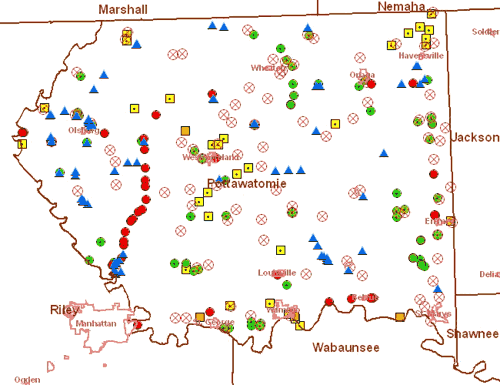
KDOT records contained geological plan and profile information on over 60 highway miles and 12 bridge construction sites. Field geologists visited many of these sites during the spring, summer, and fall of 2006 to confirm the original geological findings, pinpoint sites more precisely with GPS technology, and to photograph key locations. In areas where geological research was more sparse, a limited rotary wire-line drilling program collected nearly 400 feet of core. At the KGS headquarters in Lawrence, Kansas, field geologists with student assistants worked with website development experts to digitize and place point data online. GIS specialists, cartographic experts, and Data Access/Support Center personnel (DASC) labored to place a variety of interactive mapping tools and geographical-based overlays alongside the current digital geology map for Pottawatomie County.
Key CMI Website Capabilities:
- Links to related databases, websites, and digital libraries (USGS, KDOT, KGS . . .).
- The ability to navigate swiftly to precise locations and return to a full-county view.
- Hundreds of geographically fixed locations than can be "clicked" on to access additional data.
- View a particular site that can be overlain with digital transparencies for geology, topography, aerial photography, roads, rivers, streams, city and county boundaries, etc.
- The ability to print out a map of the specific area you want with the GIS features of your choice.
The basic website architecture and GIS framework is now complete. A critical new advantage is that the web-based computer environment provides the opportunity to have CMI information maintained and updated on a continuing basis as new data becomes available. The long range goal is now to build upon this pilot study in future projects to create updated interactive computer-based material inventories for all Kansas counties, with the priority of developing CMIs for counties where the need for information is determined to be most critical.