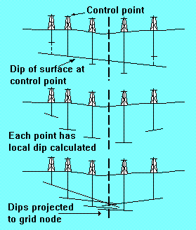
Initially, the slope of the surface at every data point must be estimated. The nearest n neighboring observations around a data point are found and each is weighted inversely to its distance from the data point. A linear trend surface is then fitted to these weighted observations. The constant term of the fitted regression equation is adjusted so the plane passes exactly through the data point. The slope of the trend surface is used as the local dip. If at least five points cannot be found around the data point or if the set of simultaneous equations for the fitted plane cannot be solved, the coefficients of a global linear trend are used to estimate the local slope. The slope coefficients are saved for each data point.
The second part of the algorithm estimates the value of the surface at the grid nodes. A search procedure finds n nearest neighboring data points around the node to be estimated. The X,Y coordinates of the grid node are substituted into each of the local trend surface equations associated with these data points, in effect projecting these local dipping planes to the location of the node. An average of these estimates is then calculated, weighting each slope by the inverse of the distance between the grid node and the data point associated with the slope. If a data point lies at or very near a grid intersection, the value of the data point is used directly as the value of the grid node.
The projection of slopes may be disadvantageous in some circumstances. For example, the method may tend to create spurious highs or lows both in areas of limited density of control points and along the edges of maps if surface dips are projected from areas where there are tight clusters of observations. Also, the two-phase algorithm obviously requires more time for computation than simpler procedures. A gridding option is available in Surface III which, in effect, deletes the initial phase of slope calculation from the gridding process. Estimates at grid nodes are then simply weighted moving averages of the surrounding data points.
Variants of the linear projection algorithm are among the most popular of those used for constructing the mathematical model used in contouring. These algorithms are especially good within areas that are densely controlled by uniformly spaced data points. However, like the piecewise linear least squares methods, they have the distressing habit of creating extreme projections when used to estimate grid nodes beyond the geographic limits of the data.
