Kansas Geological Survey, Public Information Circular (PIC) 20
Prev. Page--Townships and Sections || Next Page--Irregularities
![]()
![]()
![]()
![]()
Kansas Geological Survey, Public Information Circular (PIC) 20
Prev. Page--Townships and Sections ||
Next Page--Irregularities
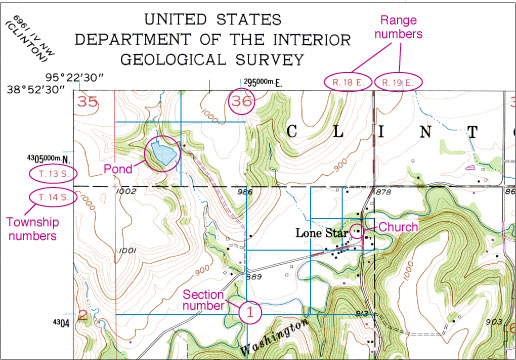
To identify the legal description of a particular piece of land, one must first locate the property on a map that shows sections, townships, and ranges, such as a U.S. Geological Survey topographic map (fig. 3) or a county ownership map. The township number can be found along the sides of the map and the range number along the top or bottom of the map. Once the township and range have been determined, one can find the section number within that 6-mile square and then determine the exact location within the section by dividing the section into quarters (fig. 3). For example, as fig. 3 illustrates, the church in the village of Lone Star is located in the SE NE NE sec. 1, T. 14 S., R. 18 E., and the pond northwest of Lone Star is located in the SW SW sec. 36, T. 13 S., R. 18 E.
Figure 3--Topographic map of a small area in Douglas County, Kansas. The church in Lone Star is in sec. 1, T. 14 S., R. 18 E., and the pond just northwest of there is in sec. 36, T. 13 S., R. 18 E. (from USGS Lone Star, Kansas, 7.5 min. quadrangle).
Although a relatively simple system, the PLSS is unfamiliar to many people, and mistakes are common. Here are some of the mistakes people make when assigning legal descriptions:
Prev. Page--Townships and Sections || Next Page--Irregularities
Kansas Geological Survey, Public Outreach
Web version January 2002
http://www.kgs.ku.edu/Publications/pic20/pic20_3.html