![]()
Prev Page--Appendices || Next Page--Geology of MRS
Appendix 1. Synopsis of Continental Rifts
Introduction
Rifts cover less than 2% of surface area of continents, yet according to Rosendahl (1987) much of the petroleum yet to be located is either directly or indirectly related to rift structures.
The Midcontinent Rift System (MRS) has been characterized along its better-exposed northern sector as a rift basin with a sub-linear system of extensional faulting forming grabens and horsts initially filled with extrusive and intrusive volcanic rocks and followed by immature terrestrial clastic sediments (arkose, feldspathic quartzite, conglomerates). However, extensive igneous activity appears to be a later event in the Kansas sector. Elongate gravity and magnetic highs and offsetting lows are characteristic along all the rift. Stratigraphy is primarily established from surface exposures around Lake Superior and isolated drill holes penetrating Phanerozoic sedimentary cover. The MRS exhibits stages ranging from active rifting with synrift sedimentation and igneous activity to sag-basin formation, the latter identified by broad patterns of subsidence accommodating a succession of less deformed sedimentary rocks.
Characteristics of ancient rifts
Rift basins require at least local extensional stress. However, regional stress may be compressional, or nearly neutral (Condie, 1982). Continental rift systems can vary considerably in their composition with marked differences noted even along the same rift system (Neuman and Ramberg, 1978). The more obvious differences in rift development include:
- A range from abundant volcanics to hale volcanic material; volcanism not necessarily closely related to extensional faulting.
- Rift magmas are generally bimodal (alkali basalt-phonolite suites or tholeiite-rhyolite suites). Calcalkaline volcanics also occur.
- Cratonic rifts are commonly associated with domal uplifts (e.g., portions of the East African Rift System).
- Rift systems are narrow and long (East African Rift System), narrow and short (Baikal in Asia and Rhine graben in Europe), or very broad extensional systems such as the Basin and Range Province in the western United States. Size and extent of the rift system are related to processes responsible for the rifting and crustal anisotropy that may have been reactivated.
- Rift systems commonly have several periods of rifting and volcanism.
- Crust and lithosphere beneath rifts are thin, where upper mantle and asthenosphere are present at shallow depths.
- Many rifts are characterized by decreasing alkalinity of the volcanism with time. The decrease is thought to be linked to decreasing influence of the continental crust on rift magmatism as the rift widens with time. An increase in alkalinity is thought to be linked to increasing distance from the rift.
- Volcanic rocks from many continental rift systems commonly reflect undepleted or enriched mantle sources.
Origin of rifting
Cratonic rifts develop on stable cratons and require some driving external force to create the extensional stress field. The force may be derived from the mantle (mantle-activated) where the asthenosphere swells or a mantle plume impinges beneath the craton. Doming and cracking of the lithosphere results. Mantle-activated rifts are characterized by relatively large volumes of volcanic rocks (Condie, 1982). Lithospheric-activated rifts are produced by lateral stress directed into the craton by lithospheric plate movement and interaction. Lithospheric-activated rifts may evolve into mantle-activated rifts if extension and faulting are sufficient to allow the asthenosphere to upwell and spread beneath the rift. The extent of upwelling and spreading will generally vary along a single rift system. Lithospheric-activated rifts, in contrast to mantle-activated rifts, are characterized by immature clastic sediments that generally exceed volcanics in abundance (Condie, 1982). A complex origin for the MRS is suggested based on information derived from the Poersch borehole.
Rifting appears to be frequently generated along old lines of weakness in the crust, e.g., the Cenozoic East African Rift System follows a Precambrian taphrogenic lineament that may be Archean in age (McConnell, 1980).
The upper 10-20 km (6-12 mi) of the crust deforms by brittle failure (faulting) while the lower crust responds to extension and sediment loading by ductile creep, leading to crustal attenuation or necking (Bott, 1982). Shallow, normal faulting associated with rifting commonly tends to flatten out or become lystric with depth.
Graben floors in cratonic rifts can remain above sea level during their development. Nonmarine sedimentation and volcanism can occur over a considerable range of time depending on rate of extension. For example, rift basins bordering Baffin Bay (Canada) span a 60-million-year (Ma) time period, while those in Eastern Greenland were intermittently active for 170 Ma until generation of the first ocean crust (Miall, 1984).
Subsidence and sedimentation rates are rapid in an active rift basin, e.g., 0.2-3.5 m (.7-11.6 ft)/1,000 years (Ka) for fluvial-lacustrine sediments in the Ethiopian Rift (Tiercelin and Faure, 1978) compared to 0.05 to 0.2 m/Ka (0.2-0.7 fUK..a) subsidence rate across the Kansas platform during Permo-Pennsylvanian development of the Anadarko basin. Rift-basin sediments are commonly interbedded with volcanic flows. Once mantle plumes or material from the asthenosphere rises beneath the lithosphere, immense volumes of flood basalts can be generated. Failed rifts such as the MRS are rift zones that aborted shortly before or after development of true oceanic crust. When extension ends, i.e. the system fails, the area of thinned lithosphere and elevated asthenosphere subsides due to thermal decay of the hot upper mantle and isostatic adjustment of the denser mafic material. An overlying sag basin develops.
Structural model
A large base of literature exists on the structural development of rift systems. However, there has been a recent convergence toward acceptance of extensional tilt-block/half-graben basins as the structural norm during active rifting (Leeder and Gawthorpe, 1987). Faulting may be both steep and gently dipping. In mixed-mode basins where there is both extension and contraction, strike-slip and thrusting can also occur (Gibbs, 1987).
Deep seismic reflection in the Viking Graben of the North Sea indicates that basins (grabens) develop above laterally linked, low-angle fault systems (Gibbs, 1987).
Figure 33 illustrates possible stages in the evolution of a generic rift from initial breakup of crust to ocean-basin formation. A failed rift such as the MRS has only advanced to a stage preceding stage 6, the juvenile ocean basin. The history of the failed rift extends from fracture, extension, and deformation of the basement and the synsedimentary fill.
Figure 33--Possible stages in the evolution of rifts (from Rosendahl, 1987). A larger PDF version is available.
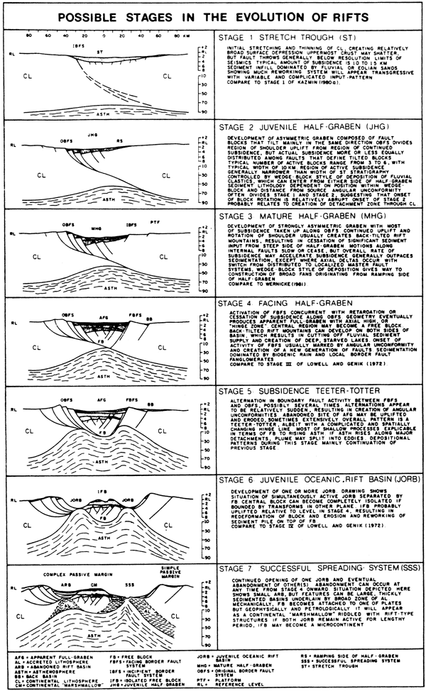
Figure 34 illustrates the sequential development of an extensional fault system typifying tilt-block to extensional basins (Gibbs, 1987). Deformation is essentially the result of progressive footwall and hanging-wall collapse. Fault movement is concurrent with basin filling and thus they can be classified as growth faults. The faulting includes a major detachment or sole fault along which minor compensating faults intersect.
The asterisk and diamonds in Figure 34 mark the position of axial depositional systems deposited in the first two stages of rift development. Depositional axes become stacked in an offset pattern as the growth faulting continues. Arrays of sedimentary wedges are developed which are back rotated, and then moved away from their original position if extension is sufficient. A rift-fill sequence observed at one location such as a borehole may be complicated by this structural dislocation. Gibbs (1987) suggests that complex sand-distribution patterns in Jurassic strata of the North Sea graben were directly controlled by this tectonic process. Rotated fault blocks commonly resemble steps on a staircase as revealed in seismic profiles (Gibbs, 1987).
Figure 34--Sequential development of extensional system. asterisk and diamond symbols mark the positions of the axial depositional systems during the first two stages of rifting (from Gibbs, 1987).
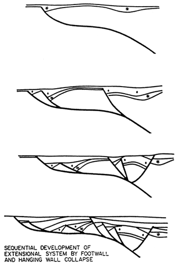
Figure 35 is a diagrammatic sketch depicting another style of extensional tectonics in which straight, high-angle faults individually extend down into the ductile, lower lithosphere. These faults have been described as domino faults. In contrast to the lystric faults, their movement does not result in as severe a translocation of sediment depocenters. Whether one type of faulting develops in preference to another is presumably related to the mechanism that creates the rifting and the type of sediments that comprise the rift and the presence of structural anisotropy in the crust.
Figure 35--High-angle, Deep-seated extensional "domino" faults (from Gibbs, 1987).
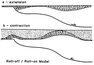
Back thrusting can occur along an earlier lystric growth fault that previously exhibited synsedimentary activity such as that shown in Figure 36 or along a major detachment fault during contraction following or during later regional subsidence (Figure 37; Gibbs, 1987). Back thrusting along earlier growth faults may be a possible explanation for structural geometries interpreted along the COCORP seismic profile.
Figure 36--Lystric, peneconteporaneous faulting at stage (a) with rollover followed by latter back thrusting (b) based on field work and seismic data in southern England and English Channel (from Gibbs, 1987).
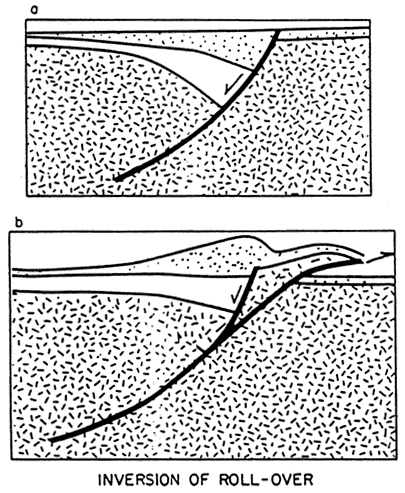
Figure 37--Hanging-wall basins developed during extension (stage a), succeeded by deformation during contraction (stage b) during regional subsidence (Gibbs, 1987).
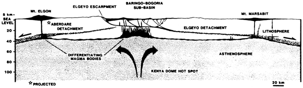
Bosworth (1987) provides a model for an alternating low-angle detachment- fault system that is proposed to link portions of the East African Rift System (Figure 38). The detachment fault is the main bounding fault over which compensating faults are developed forming half grabens. Lithospheric attenuation occurs beneath the flattened portion of the detachment fault coinciding with the axis of the rift system (Figure 39).
Figure 38--Tectonic interpretation of western Kenya along Gregory Rift Valley (East African Rift System). Central zones shown by dot pattern is zone of crustal thinning. Bold arrows indicate relative motion of plate above each detachment. Detachment intersects land surface as a bounding fault in rift valley (hachured heavy line). Oppositely directed detachments ineract in wrench-dominated accommodation Zone (AZ) (shear zone shown as small arrows). Off-axis volcanism (radiating lines) appears to be localized where detachments merge in zone of lithospheric thinning (randomly dashed zone paralleling axial zone of crustal thinning). Dots are epicenters of historical earthquakes (from Bosworth, 1987).
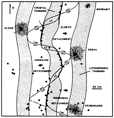
Figure 39--West to east schematic cross section through Gregory Rift, western Kenya. Topography exaggerated 2X. No vertical exaggeration in subsea depths. Main active detachment dips eastward beneath axis of rift and produces lithospheric thinning where intersects with base of lithosphere (beneath Mt. Marsabit). Crustal thinning and differentiation of lower lithosphere occur beneath the axis of the rift (from Bosworth, 1987).
The process of rifting according to the model of Bosworth (1987) begins with a symmetrical graben with two active bounding faults. One of the bounding, basin-margin faults eventually truncates the other and further significant movement on the truncated fault is arrested. From that point a half-graben extensional basin develops with the bounding fault becoming the detachment surface as it soles out with depth. Continued extension results in ductile thinning of the lower lithosphere when drag along the detachment fault exceeds the strength of the lower lithosphere. The crustal blocks founder, and volcanic rock eventually is extruded and intruded into the deepened graben system (Figure 39). Calculations by King (1987) indicate about 8 km (5 mi) of extension occurred over 80 km (50 mi) of the Gregory rift width (10% extension), located along the Kenyan portion of the East African rift system. The depth of detachment for these failed rifts based on section balancing and restoration suggest the bounding normal faults sole out at 12-18 km (7-11 mi) in the Gregory Rift (Bosworth, 1987).
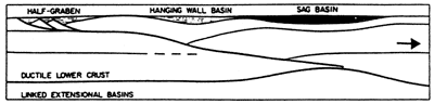
Figure 40 illustrates a regional view of three different extensional basins that are linked by a common detachment fault (Gibbs, 1987). The diagram is derived from regional analysis of North Sea seismic and borehole data and may be applicable to other ancient rift systems. The sag basin is saucer shaped and can be quite broad in areal extent. The hanging-wall basin develops along a more abrupt change in the inclination of the detachment fault. Faulting in the sag and hanging-wall basins is characteristically minor.
Figure 40--Possible types of linked extensional basins viewed in cross section transverse to half-graben axis developed above a crustal detachment. Note crustal thinning beneath sag basin. Sag basin is younger basin developed during cooling of upwelled asthenosphere (from Gibbs, 1987).
Sedimentation in rift basin
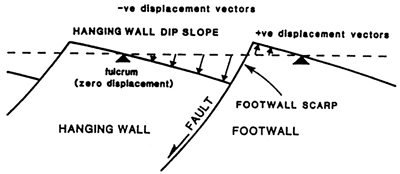
Half-graben tilt-block systems are characteristic of extensional tectonics. The resulting basin geometry and history influence sedimentation in active and ancient rifts, e.g., continental rifts such as the African Rift System (Browne and Fairhead, 1983). Figure 41 describes the tectonic slopes (basement surfaces) associated with half grabens (Leeder and Gawthorpe, 1987). During active tectonism the hanging wall downtilts and the footwall is uplifted around a point of zero displacement (the fulcrum; Figure 41) creating what can be substantial topographic relief The footwall forms an escarpment and the hanging wall forms a broad gentle slope. The general movement is that of tilting produced by rotation along the lystric faults that flatten with depth (Figure 34). The position of the zero-displacement point and its lateral movement is dependent on the overall structural development. For example, as a lystric fault develops it produces a rotation of the tectonic slope and would cause a migration of the fulcrum up the dip slope of the hanging wall. Any migration of the fulcrum would lead to progressive onlap of sediments deposited along the axis of the basin. In contrast, the steeper "domino" fault system may not exhibit this rotation and associated lateral movement of the fulcrum.
Figure 41--Development of tectonic slopes associated with a simple tilt block/half graben (Leeder and Gawthorpe, 1987).
Fault movement and concurrent fiwng are instantaneous, episodic events in an active extensional system, e.g., Hebgen Lake area of Montana (Fraser et al., 1964). Modest fault displacements can have a significant impact on river and alluvial-fan gradients and lake and marine deposition, e.g., earthquakes and resultant subsidence in the shoreline migration. Such effects should produce distinctive signals in the basin-fill succession and may result in distinctive sedimentary cycles (Leeder and Gawthorpe, 1987).
Sedimentary sequences encountered in rift basins are controlled by processes of erosion, sediment transfer, and deposition. Climatic conditions, lithology of eroded terrain, and proximity to sea-level also influence the nature of deposition, but tectonics by far has the major influence in an active rift setting. Sedimentation and subsidence rates are tied to the rate of extensional tectonism (Leeder and Gawthorpe, 1987) and, as previously indicated, can be exceptionally high. We believe that similar tectonic activity is the cause of the sedimentary sequences and packages observed in the Poersch borehole.
Continental graben with interior drainage
Sedimentation in a graben system may be internal to one or more rift basins isolated from others by adjoining fault scarps (Figure 42). Commonly in this setting subsidence rate exceeds the rate of sedimentation. Sediments consist of high-gradient alluvial cones extending off footwalls, and low-gradient fans extending down hanging-wall slopes interfingering with lacustrine deposits. The lake sediments may include evaporite minerals or organic-rich deposits depending on climate and depth. Aeolian deposits such as sand dunes could also co-exist with alluvial fans and cones, where they are not active, depending on rainfall. Periodic faulting would reactivate alluvial fans and modify the sedimentary sequence. During this faulting, the hanging-wall block commonly rotates, increasing the slope of the surface of the block. This increase in slope causes an increase in the stream gradients. The stream can then more competently carry coarser material farther basinward in the half-graben depositional system. On the dip slope, renewed progradation of fan deposits could result in a coarsening-upward cycle. These deposits would thin downslope toward the lacustrine deposits, if the latter existed.
Figure 42--Block diagram depicting sedimentological features of a continental basin with interior drainage developed in a half graben (from Leeder and Gawthorpe, 1987).
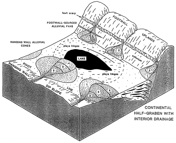
Downslope along the hanging wall, the lake sediments would exhibit sharp transgression over lower slopes of alluvial cones adjacent to the footwall scarp leading to interruptions in the sequence of coarsening-upward sequences. Uplifted positions on alluvial fans and cones in the same basin may undergo extensive soil formation due to extended subaerial exposure (Leeder and Gawthorpe, 1987).
Alluvial Fans
The sedimentary criteria for recognizing alluvial-fan deposition include rapid fining in downslope direction and presence of debris flows and the following major facies (Rust and Koster, 1984):
- clast-supported, commonly imbricate gravel with poorly defined subhorizontal bedding;
- muddy matrix-supported gravel without imbrication or internal stratification;
- trough crossbedded clast-supported gravel;
- planar crossbedded gravel, transition from clast-supported gravel through sand matrix-supported gravel to sand.
Alluvial fans are localized deposits (Figure 43 and Table 4). Sediments are immature and poorly sorted. Lacustrine deposits can be more or less extensive depending on rainfall and drainage area. Waters may reach sufficient depths to promote conditions for anoxia as dissolved oxygen is removed. In such conditions organic matter can then accumulate if productivity is sufficient, resulting in organic-rich deposits.
Figure 43--Diagrammatic cross section of alluvial fan showing proxmal-distal facies variation. See Table 4 for facies identification (from Rust and Koster, 1984).
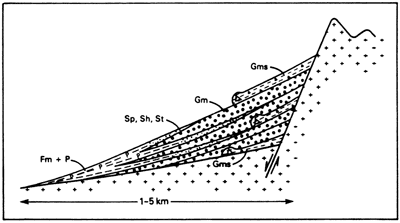
Table 4--Facies typical of fans and braidplain deposits (from Rust and Koster, 1984).
| Major facies | |
|---|---|
| Gm | Clast-supported, commonly imbricate gravel with poorly defined subhorizontal bedding. |
| Gms | Muddy matrix-supported gravel without imbrication or internal stratification |
| Gt | Trough cross-bedded clast-supported gravel |
| Gp | Planar cross-bedded gravel, transitional from clast-supported gravel through sand matrix-supported gravel to sand (Sp) |
| Minor facies | |
| Sh | Horizontally stratified sand |
| St | Trough cross-stratified sand |
| Sp | Planar cross-stratified sand |
| Fm | Massive fine sandy mud or mud |
| Fl | Laminated or cross-laminated very fine sand, silt or mud |
| P | Pedogenic concretionary carbonate |
Continental graben with through drainage
Another example of sedimentation in a continental-rift basin has axial through-drainage (Figure 44; Leeder and Gawthorpe, 1987). Again alluvial cones and fans prograde off nearby fault blocks. However, fluvial deposits occupy the topographic low areas near the axis of maximum subsidence. With time and continued episodic subsidence tied to tectonic events in the basin system, a stacked sequence of alluvial-sand bodies are deposited along the axis of the basin (Bridge and Leeder, 1979). The axial-river system is displaced from the position of maximum subsidence by impinging alluvial fans. Accordingly, both deposits may be interdigitated. Moreover, additional faulting within the basin may interrupt stacking. As the tectonic block is tilted, preferential downslope cut-off and minor avulsion occur and the river system is generally displaced toward the footwall. Abnormally wide channel-belt sand bodies result (Leeder and Gawthorpe, 1987). Volcanic activity may disrupt the through-going fluvial systems.
Figure 44--Block diagram illustrating continental half graben with axial through-going drainage (from Leeder and Gawthorpe, 1987).
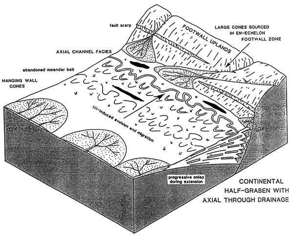
In arid conditions red soils would develop on emergent settings updip on the hanging wall away from active dip-slope cone progradation. Importantly, sand- and silt-sized particles may be mobilized by wind along flanks of rivers to form dune fields leading to deposits of sorted, rounded, and frosted sandstone accumulations. In general, accelerated maturation of the sediment would occur with aeolian influence.
A natural evolutionary sequence in rift-basin development would begin with interior drainage in isolated grabens followed by through-drainage as graben systems became more extensive, perhaps linked through movement along a bounding fault. Also through-drainage would result when subsidence wanes and sediments fill in topographic lows, resulting in a more level depositional surface.
The lower sedimentary succession observed in the Poersch well suggests a similar evolution. The lowest sedimentary sequence, "A" (see Figure 23), contains coarse- and fine-gained arkosic sandstones with mixed volcanic debris in several coarsening-upward packages resembling an alluvial fan-dominated sequence. The middle sequence, "B," contains predominantly very coarse, fining-upward packages while the upper "C" sequence contains finer gained fining-upward packages. Sequences "B" and "C" appear to be primarily fluvial in origin (coarse [proximal] to fine [distal] braided stream deposits) suggesting a more through-going depositional system. Trends in grain size, composition, and vertical-sequence development suggest possible waning tectonic activity.
This lower sedimentary succession is preceded by additional rift-fill deposits not penetrated in the Poersch well. What is present in the Poersch may represent a tectonic interlude that is not part of the dominant long-term tectonic history of the rift.
Prev Page--Appendices || Next Page--Geology of MRS
Kansas Geological Survey, Texaco Poersch #1 Report
Placed on web March 5, 2010; originally published June 1988.
Comments to webadmin@kgs.ku.edu
The URL for this page is http://www.kgs.ku.edu/Publications/OFR/1988/OFR88_22/09_app1.html